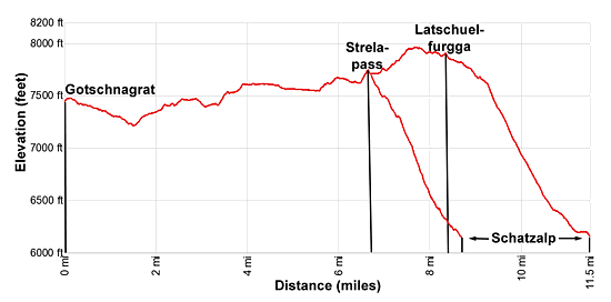
Details: Davos Panoramaweg - Gotschnagrat to Schatzalp 
Distance: 4.7 - 11.5 miles (one way)
near Davos in Eastern Switzerland
Hike Facts
- Distance: 4.7 - 11.5 miles (one way)
- Elevation: 7,484-ft. - 7,700-ft.
- Elevation Gain: 390-ft.
- Difficulty: moderate
- Trail Highlights: See Trail Intro
- Basecamp(s): Davos
- Region: Eastern Switzerland
The Davos Panoramaweg, a classic high traverse above the west side of the Davos Valley, features great views of the high peaks and glacier clad summits towering above the Davos, Klosters, Fluela, Dischma and Sertig valleys.
Gotschnagrat to Strela Pass
Distance from Trailhead: 6.4 miles (one way)
Ending/Highest Elevation: 7,700-ft.
Elevation Gain: 390-ft.
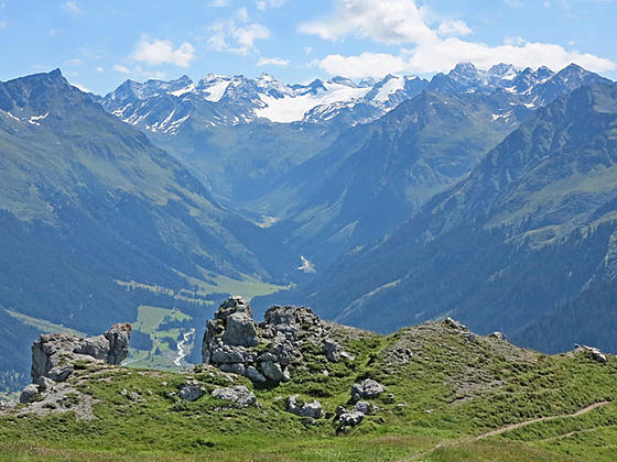
Take the Gotschnabahn (Gotschnagrat cable car) from Klosters Platz to Gotschnagrat (7,484-ft.). (See trailhead directions below.) Before starting the hike enjoy the panoramic views from the Gotschnagrat overlook high above the confluence of the Landwasser (where Davos is located) and Prattigau Valleys. Rugged Casanna and the Gruenhorn rise along the ridge to the west of Gotschnagrat. Madrissa and the peaks towering above Klosters fill the skyline to the north/northeast. The Silvrettahorn and its massive glaciers dominate the view to the east. Across the Davos valley views extend up the Monchalp Valley to the Pischahorn.
When you are done taking in the views find the trail signpost outside the lift station. Follow the Panoramaweg, a broad track, heading southwest toward Parsennhutte, Parsennfurgga and Strelapass. At all turns stay on the Panoramaweg.
At 0.4 miles reach a junction with a trail labeled "Bergwanderweg" branching right. Take this trail which descends on gentle grades through meadows, contouring beneath the Gruenhorn and Casanna to Parsennhutte at 1.4 miles.
Along the way views open to the Davosersee (Davos Lake), Davos Dorf and the peaks rimming the Dischma and Sertig Valleys, long tributary valleys extending southeast from the main Landwasser Valley. At Parsennhutte the trail rejoins the broad track.
The area around Parsennhutte is littered with ski lifts and buildings. Thankfully you soon leave the ski area behind. At 1.7 miles take the trail branching left to stay on the Panoramaweg. The broad track to the right continues up a side valley to the Totalpsee.
Our trail now ascends on easy grades through rocky meadows and scree covered slopes, traversing beneath the east facing slopes of the Totalphorn. Behind you are good views of the Silvrettahorn, Casanna and the Gotschnagrat area.
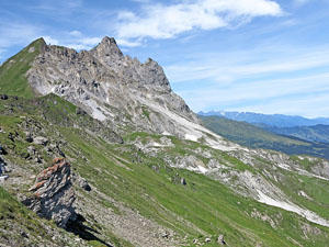
At 2.8 miles the path curves around a ridge extending from the Totalphorn and views open to the Salezer Horn at the end of the Mittelgrat (Mittel ridge) extending east from the Weissfluhjoch. The path now descends to cross the Totalpbach stream and then ascends to cross the northeast ridge of the Salezer Horn at 3.5 miles.
The ridge crest is a great spot to stop and take in the views. You are now looking directly up the Dischma Valley to the east. The Fluela Schwarzhorn, Piz Grialetsch, Scalettahorn and Sattelhorn anchor the cirque towering above the head of the valley. To the north the Madrissa massif forms the back drop for the Gotschnagrat area and Casanna. To the northeast the high peaks of the Silvretta massif and the summits rising above the Monchalp valley fill the skyline.
Beyond the ridge the trail contours through pretty meadows beneath the east and south facing flanks of the Salezer Horn, traveling through a section of avalanche barriers along the way. Views now extend south as far as Piz Ela and the Tinzenhorn towering above the Albula valley. To the southeast, across the Landwasser Valley, the Alplihorn and the peaks rimming the Sertig Valley are now in focus. Ahead the rugged gray crags and summit of the Gross Schiahorn dominate the view.
At 4.2 miles reach a junction with a trail dropping down to Station Hohenweg, the middle station on the Parsenn funicular to the Weissfluhjoch. Hikers looking for a shorter day can turn left here, descend to the station at 4.7 miles and then take the funicular down to Davos Dorf.
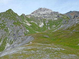
Beyond the junction the trail passes under the funicular and then contours around the southeast facing slopes of the Weissfluhjoch (9,331-ft.). At all junctions stay on the Panoramaweg toward Strelapass (Strela Pass) and Schatzalp.
At 5.0 miles the trail curves to the southeast as it traverses beneath the rugged east ridge of the Schiahorn. Soon the path swings around the end of the ridge, passing through an area of avalanche barriers as it heads west on an undulating trail under the Schiahorn’s south facing flanks. Ahead views open to Strelapass, a notch on the ridge. To the southeast are fine views of the peaks rimming the Sertig Valley.
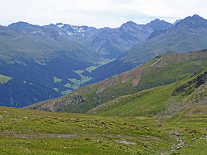
At 6.2 miles a short steep climb leads to Strela Pass (7,700-ft.) at 6.4 miles. Here fine views extend northwest to the high peaks rising above Langwies and Chur. The Weissfluhjoch dominates the view to the north. The Sertig Valley stretches southeast from Davos Platz to the Mittaghorn (8,970-ft.) where the valley splits into the Chuealp and Ducan Valleys, each rimmed by high summits.
After taking in the views hikers have a choice. The traditional Panoramaweg hike descends from Strelapass to Schatzalp at 8.5 miles. At Schatzalp a funicular descends to Davos Platz. Alternatively, extend the hike by walking to the Latschuelfurgga and then to Schatzalp for an 11.2 mile hike.
Strelapass to Schatzalp
Distance from Trailhead: 8.5 miles (one way)
Ending/Highest Elevation: 6,106-ft.
Elevation Gain: -1,594-ft.
After taking in the views at Strelapass, find the signpost near the Berghaus Strelapass. Head east/southeast toward Strelaalp and Schatzalp, descending on moderately steep grades down a broad grassy ridge above the south side of the Schiatobel Valley. As you descend enjoy views of the Schiahorn, the Sertig Valley and Davos Platz.
At 8.0 miles the path curves sharply to the southwest, descending on moderate grades to the historic Hotel Schatzalp (6,106-ft.) and the Schatzalpbahn, a funicular dropping down to Davos Platz, at 8.5 miles. Elevation loss from the Strelapass to Schatzalp is 1,594-ft.
Strelapass to Latschuelfurgga to Schatzalp
Distance from Trailhead: 11.5 miles (one way)
Ending/Highest Elevation: 7,963-ft.
Elevation Gain: -1,857-ft.
Note: This segment gains 260-ft. and then loses 1,857-ft.
Extend the day by continuing the hike to the Latschuelfurgga, a saddle on the ridge between the Chupfenflue and Wannengrat. Not many hikers continue this way so you should now enjoy some solitude.
At a signpost near the Berghaus Strelapass, head south/southwest on a good trail toward Latschuelfurgga. The path travels by the top of the lift at Station Strelapass and then ascends on moderate grades past the Strelasee, a small tarn, to the top of a low ridge. From the ridge enjoy views of the Jakobshorn, across the valley to the southeast, and the high peaks rising above the Sertig, Dischma and Fluela valleys to the east/northeast. Ahead views open to the Latschuelfurgga area.
The path descends on easy grades from the ridge crest to the Latschuelfurgga saddle at 8.2 miles. To the east are distant views of the high peaks towering above Chur and beyond. To the southwest the rugged Mederger Flue and Chorbsch Horn rises above a small, corrugated valley.
A trail drops down the west side of the pass toward Arosa. We take the trail descending east toward Podestatenalp and Schatzalp. Initially the trail descends on moderately easy grades. At 9.3 mile the path steepens as it drops through pastures, passing the small alp at Schonboden. Switchbacks facilitate the stiff descent to the junction at Podestatenalp at 10.5 miles.
At the junction turn left toward Schatzalp. The trail now enters the trees and descends on moderately steep switchbacks. As you near Schatzalp, the path travels through a pretty flower garden and passes signs to the Alpinum, an interesting botanical garden. Beyond the garden the trail leads to Schatzalp and the funicular to Davos Platz at 11.5 miles. Elevation loss from the high point along the ridge crest to Schatzalp is 1,857-ft.
Elevation Profile
Driving Directions
This hike can be done in either direction.
From Davos Dorf Bahnhof to the Gotschnabahn (Gotschnagrat cable car): Take the train from Davos Dorf heading toward Landquart or Klosters Platz and get off at Klosters Platz. The Gotschnabahn (Gotschnagrat cable car/Parsenn Klosters) is located on the west side of the platform. Purchase a one-way ticket on the cable car. The train ride should take 25 minutes.
From Davos Dorf Bahnhof to Schatzalp: From the Davos Dorf train station, take the #1, 3 or 4 bus heading to Davos Platz Schatzalpbahn (the funicular in Davos Platz climbing to Schatzalp). Get off at the funicular station and purchase a one-way to the Schatzalp. You can check the current bus schedules at the SBB website/SBB app to find the stop nearest to your accommodations.
From Schatzalp to Davos Dorf Bahnhof: Take the funicular from Schatzalp to the bottom station. Catch a #1 or 3 bus headed to Davos Platz or Davos Glaris. Get off the bus at Davos Platz, Postplatz and walk to the Davos Platz train station. At the station take the train to Davos Dorf. You can check the current bus schedules at the SBB website/SBB app to find the stop nearest to your accommodations.
Trail Resources
Trail Intro / Trail Photo Gallery / Trail Map
Basecamp(s) Information:
Davos
Region Information:
Eastern Switzerland
Other Hiking Regions in:
Switzerland