Durrboden to Fuorcla da Grialetsch and Fuorcla Rad 
Distance: 4.8 - 7.7 miles
near Davos in Eastern Switzerland
By: Diane Greer
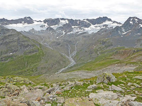
View of the Grialetsch cirque
Two scenic passes and views of the high peaks towering above four beautiful valleys are the highlights of this trail climbing from Durrboden to Fuorcla da Grialetsch and Fuorcla Radont. Along the way the trail passes by pretty tarns and enjoys fine views of the Scaletta and Grialetsch Glaciers.
- Distance: 4.8 - 7.7 miles (RT)
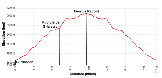
- Elevation: 6,575-ft. at Trailhead
Maximum elevation - 9,137-ft. - Elevation Gain: 2,562-ft.
- Difficulty: moderate-strenuous
- Basecamp: Davos
- Region: Eastern Switzerland
Trail Description - Durrboden to Fuorcla da Grialetsch and Fuorcla Rad
This trail packs a lot of scenery into a relatively short distance. Beginning in the Dischma Valley beneath the Schwarzhorn, the path ascends the Furgga Valley to the Grialetsch Pass/Col, a pretty area with two small lakes and fine views of Piz Sarsura massif and the Grialetsch Glacier. The area around the hut is a great place for a picnic or to simply relax in the sun amid the beautiful scenery.
Hikers looking for a longer day will want to continue to the Fuorcla Radont on a trail climbing through rocky meadows, scree covered slopes and a small boulder field. This segment of the path offers splendid views of Piz Grialetsch, Piz Vadret and Piz Sarsura anchoring the cirque at the head of the Grialetsch Valley along with the summits rimming the valley's eastern wall. As you crest Radont Pass great views unfold of the Schwarzhorn towering above Fluela Pass.
Hiking from Durrboden to Fuorcla da Grialetsch and Fuorcla Radont
Start the day with a scenic postbus ride up the Dischma Valley to the Berggasthaus Durrboden, the last settlement near the head of the valley. (See trailhead directions below.) The valley, a southeast trending tributary of the Landwasser Valley, is clad in pretty pastures sprinkled with small villages nestled beneath rugged peaks.
The historic Berghaus includes a nice restaurant with lovely views of the Scaletta Glacier, Piz Grialetsch, the Scalettahorn and neighboring peaks rising above the of the Gletschtalli. The Raduner Rothorn and Schwarzhorn tower above the east side of the valley.
Above the Berggasthaus the valley branches into three lobes ringed by high summits. To the southwest is the main Dischma valley rimmed by the Bocktenhorn, Leidhorn and Augstenhureli to the west and the Peak 2834 (9,298-ft.) to the east. The Scaletta Glacier spills down the slopes of the Scalettahorn and Piz Grialetsch in the aptly named Gletschtalli (Glacier Valley) to the southeast. Our trail ascends the Furgga Valley, with its lovely lake and the popular Grialetsch Hut, to the east.
Walk along the east side of the Berghaus to the end of the car park. Here a trail signpost points to a broad track heading southeast through pastures to Scaletta Pass, the Grialetsch Hut and Fuorcla Radont. A short distance beyond the track splits. We bear left on the trail to Grialetsch Hut and Fuorcla Radont. The trail to the right leads to Scaletta Pass.
Our trail ascends on moderate grades through meadows to the east of the Furggabach, a stream draining the Furgga Valley. Ahead are nice views of the Scaletta Glacier clinging to the rugged slopes above the Gletschtalli. At 0.6 miles the grade steepens and views open southwest to the Chuealphorn, Augstenhureli and Leidhorn rising above the Scaletta Pass area.
At 1.1 miles the trail curves to the left (east) and reaches a junction with a trail branching right toward Scaletta Pass. We continue on the main trail to the Grialetsch Hut. The path now climbs on steep grades through rocky meadows up the north side of the Furgga Valley. The Furggabach spills down the valley floor beneath the trail. The rugged slopes of the Raduner Rothorn tower overhead.
At 2.0 miles the grade abates as the trail traverses along the south side of the Furggasee (Lake Furgga), a pretty tarn set beneath the south facing slopes of the Raduner Rothorn and Piz Radont. Past the lake the path ascends on gentle grades to Fuorcla da Grialetsch (Grialetsch Col/Pass) (8,320-ft.) and a trail junction at 2.4 miles. Here views open to the Piz Sarsura massif and the Grialetsch Glacier to the east/southeast. To the south the Chilbiritzenspitz towers above the pass while two small tarns lie nestled amid the meadows and rocky slopes.
From the junction a trail wanders south to the Grialetsch Hut with more great views of the Grialetsch Glacier and the Piz Sarsura massif along with the beautiful area around the Fuorcla da Grialetsch. The hut offers dormitory accommodations and refreshments.
The hut is a great turnaround point for hikers looking for a shorter, easier day. Simply find a perch with great views of the tarns and the surrounding summits to enjoy a picnic lunch and then retrace your steps to the trailhead for a 4.8 mile round-trip hike with a 1,745-ft. elevation gain.
For hikers with the time, energy and good weather, I recommend continuing beyond the Fuorcla da Grialetsch to Fuorcla Radont. This segment of the trail features terrific views of the high peaks towering above the Grialetsch Valley. From the pass enjoy stunning views of the Schwarzhorn soaring above the Radont Valley.
To reach Fuorcla Radont, turn left at the junction. The trail ascends steeply through rocky meadows to a bench along the west facing flanks of Piz Radont, high above the west side of the Grialetsch Valley. As you climb turn around for birds-eye-views of the Fuorcla da Grialetsch area along with splendid vistas of Piz Grialetsch, Piz Vadret and Piz Sarsura anchoring the cirque at the head of the Grialetsch Valley. The Grialetsch Glacier clings to the cirque's rugged slopes.
Crest the bench at 2.75 miles. The path now traverses the bench beneath the rugged slopes of Piz Radont. In route pass a small tarn and traverses the scree clad slopes of an avalanche chute.
At 3.2 miles the ascent resumes up rocky meadows and scree covered slopes. A short section of this trail segment entails a somewhat tedious crossing of a boulder field. Red and white slashes on the rock will keep you on track through the boulders.
At 3.7 miles a grassy knoll offers a great spot to take a break and enjoy the views of the high peaks rimming the Grialetsch Valley. Beyond the knoll a moderate climb, passing above two small tarns, leads to Fuorcla Radont (Radont Col/Pass) at 3.85 miles. The pass enjoys fine views of the Schwarzhorn soaring above the Radont Valley along with the Grialetsch cirque. Below the west side of the pass is a rocky moonscape.
You now have two choices. The easiest option is to turn around and enjoy the great views as you head back to Durrboden got a 7.7 mile round-trip hike. Alternatively, you can drop down a very steep, rocky trail to Fluela Pass, losing over 1,300-ft. in 2.2 miles.
The trail over Fuorcla Radont can be combined with a hike to the Schwarzhorn for a challenging and scenic 8.4 miles point to point hike. The pass is served by regularly scheduled buses from Davos. See the Fluela Pass – Schwarzhorn - Durrboden hiking description for more information on this option.
Elevation Profile
Driving Directions
Davos to Durrboden: From the Bahnhof (train station) at Davos Dorf (at the northeast end of town), board the bus to Durrboden. Get off bus at the last stop. The scenic ride up the Dischma Valley takes about 30 minutes. Regularly scheduled buses return to Davos via the same route. A schedule is posted at the bus stop at Durrboden. You can also check the current schedules at the SBB website/SBB app.
Note: Buses and trains travel between Davos Dorf and Davos Platz. The train ride takes three minutes. Buses take a variety of routes through the town. Pickup a bus schedule at the Tourism Office at the Davos Dorf Bahnhof or near the Sportzentrum in the middle of town, or consult the SBB website/SBB app to find the stop closest to your accommodations.
Trail Resources
- Trail Photo Gallery
- Trail Maps
- Basecamp(s) Information: Davos
- Region Information: Eastern Switzerland
- Other Hiking Regions in: Switzerland