Hike Facts
- Distance: 11.0 miles (one way)
- Elevation: 6,099-ft. - 8,986-ft.
- Elevation Gain: 2,887-ft.
- Difficulty: strenuous
- Trail Highlights: See Trail Intro
- Basecamp(s): Davos
- Region: Eastern Switzerland
This terrific hike crosses two panoramic passes, Sertig Pass and Scaletta Pass, and travels through five scenic valleys. Along the way hikers enjoy splendid views of Piz Kesch, Piz Vadret, the Ducan Ridge, the Schwarzhorn and the Chuealphorn, to name a few.
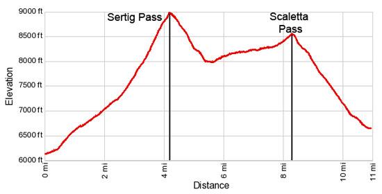
Sertig Pass
Distance from Trailhead: 4.2 miles (one way)
Ending/Highest Elevation: 8,986-ft.
Elevation Gain: 2,887-ft.
Note: This trail can be hiked in either direction. I recommend catching the first bus of the day so you get over the high passes earlier in the day, always a good idea in the mountains. It will also insure you have plenty of time to enjoy the hike while still making the last bus back to Davos from either Sertig of Durrboden.
Take the bus from Davos to Sertig Sand (see trailhead directions below). The bus stops in front of the Walserhuus Restaurant/Hotel in Sertig Sand (6,099-ft.). Walk south along the road skirting the east side of the restaurant, past the parking lot (left). The trail signpost is just beyond the parking lot. Continue straight ahead on the alp road toward Chuealp, Sertigpass, Scalettapass and Durrboden.
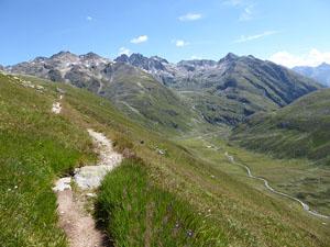
The trail ascends on easy grades through pastures along the east side of the valley. The Sertigbach, a pretty stream, meanders down the idyllic valley beside the trail. Ahead the Mittaghorn, Plattenflue and Piz Duncan, rising along the southeast side of the Ducan Valley, dominate the view.
Reach a “Y” intersection at 0.4 miles and turn left (southeast) up the Chuealp Valley toward Sertig Pass. The trail to the right (south) ascends the Ducan Valley to the Fanezfurgga and Monstein. See the Sertig to Monstein hike for more information.
Follow the trail as it ascends the dirt road on moderate grades. Behind you the Alplihorn and Leidbachhorn tower above the west side of the Sertig Valley.
At 1.4 miles views open to the rugged Chuealphorn at the head of the Chuealp Valley. The Mittaghorn soars above the trail to the west while the delightful Chuealpbach flows along a rocky streambed to the right (west) of the trail.
Pass a barn/milking station at 1.7 miles and then reach a junction at 2.4 miles near Grunsee (7,208-ft.), a small tarn. Here the road ends. Bear right on the trail crossing a wood bridge over the Chuealpbach. Beyond the bridge the path climbs steeply through pastures along the west side of the valley. A second smaller bridge at 2.4 miles keeps your feet dry while crossing a stream cascading down the steep, grassy slopes above the trail.
The trail now climbs a few switchbacks and then continues on a diagonal up the west side of the valley. As you ascend enjoy ever improving views of the rugged cirque at the head of the valley. Behind you the Bocktenhorn dominates the view to the northeast.
Soon meadows give way to scree-covered slopes. At 3.9 miles views open to Sertig Pass, the saddle on the ridge at the head of the valley. Nestled in a depression below the trail is a small tarn, covered in ice/snow early in the season.
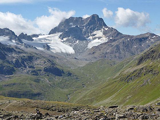
The trail now climbs steeply up the west side of a rocky bowl to Sertig Pass (8,986-ft.) at 4.2 miles. As you crest the pass Piz Kesch (11,214-ft.), the highest peak in the Albula Alps, burst onto the scene to the south. The Porchabella Glacier flows down the flanks of this majestic peak, soaring above the head of the Tschuvel Valley, while Piz Murtelet and Piz Forun rim the valley to the west. The serrated peaks of the Ducan Ridge fill the skyline to the west of the pass.
The pass is a great place to take a break and enjoy the views. Most parties turn around at this point and retrace their steps to Sertig Sand. If you have the time and energy, along with good weather, I highly recommend continuing over the Sertig Pass to Scaletta Pass and Durrboden.
To Scaletta Pass
Distance from Trailhead: 8.3 miles (one way)
Ending/Highest Elevation: 8,550-ft.
Elevation Gain: 540-ft.
To continue the hike, follow the trail down the south side of the pass toward Scalettapass (2-hr) and Durrboden (3-hr 15-min). (Ignore the trail heading right (southwest) toward Lai da Ravais, Chants and Bergun.) Red and white blazed rocks mark the path dropping steeply through rocky meadows.
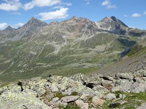
As you descend, views open west to Lake Ravais and Lake Ravais Suot (south) along with Piz Ducan towering above the northeast end of the Ducan Ridge. To the south Piz Kesch commands your attention.
Pass a junction with a trail branching right (northwest) and climbing toward the Ravais Lakes, Chants and Bergun at 5.0 miles. Beyond the intersection the grade eases a bit as the descent continues down the Val Sartiv (Sartiv Valley) to a second junction at 5.2 miles. Here a trail branches right (south) and crosses a creek heading toward the Kesch Hut, Alp Funtauna and Cinuous-chel/Brail. Our trail to Scaletta Pass curves to the left and descends steeply along the left (east) side of the stream.
At 5.3 miles reach an intersection with another trail branching right toward the Kesch Hut and Chants. We turn left (east) toward Scalettapass and Durrboden. Ahead views open to the Piz Vadret massif. Before continuing, turn around for your last good views of Piz Kesch. With binoculars or a zoom lens on a camera you should be able to see the Kesch Hut on a grassy knoll along the right (west) side of the valley.
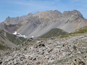
Our trail now ascends on easy grades through meadows sprinkled with wildflowers along the north side of the Val Funtauna (Funtauna Valley). Soon the trail curves to the left (northeast), traveling beneath the rugged south face of the Chuealphorn. Along the way enjoy terrific views of the Piz Vadret massif, which is soon joined by Piz Grialetsch, to the northeast. Alp Funtauna is seen on the valley floor. Piz Musella rises at the end of the ridge rimming the south side of the valley. At 6.5 miles views open to the Chuealphorn towering above the north side of the trail and the peaks rising above the Engadina Ota (Upper Engadine) Valley to the southeast.
At 7.0 miles the trail curves left (northeast) into the Val Susauna, ascending through meadows on easy to moderate grades toward Scaletta Pass. In three-quarters of a mile our path joins with a trail coming up from the Alp Funtauna. Scaletta Pass, the saddle at the head of the valley, is now in sight.
Follow the path as it ascends on moderate grades, crossing several streams carrying meltwater from glaciers and snowfields on the flanks of the Chuealphorn. Reach Scaletta Pass (8,550-ft.), a crossing on a medieval trade route between Chur, Davos and S-chanf, at 8.3 miles.
The pass is a great place to take a break and enjoy the views. The rugged ridge dominated by the Schwarzhorn, towering above the east side of the Dischma Valley, dominates the views to the north. Behind you, Piz Musella, Piz Viluoch and Piz Griatschouls fill the skyline to the south. The Chuealphorn and its glacier rise above the ridge to the west of the pass and are easiest to see before reaching the pass.
Just below the north side of the pass is a small shelter. In front of the shelter are several large, flat rocks – the perfect place for a picnic or a break.
Durrboden (Complete Hike)
Distance from Trailhead: 11.0 miles (one way)
Ending/Highest Elevation: 6,620-ft.
Elevation Gain: -1,930-ft.
To finish the hike, descend the trail on moderately-steep grades down the north side of the pass toward Durrboden (1-hr 15-min). The path drops through rocky meadows and then scree-covered slopes, crossing a few streams along the way. As you descend views open to the Bocktenhorn rising along the west side of the valley. To the northeast, the Raduner Rothorn and Piz Redont tower above the Furgga Valley.
You are now sharing a trail with mountain bikes. As you descend, watch for bikes coming down from the pass. Thankfully the rocky trail forces them to go slowly.
The scree covered slopes gradually give way to meadows filled with wildflowers during the end of July and beginning of August. At 9.3 miles views open east to the trail climbing to Fuorcla da Grialetsch (Grialetsch Pass) beneath the slopes of the Raduner Rothorn.
Pass a junction with a cutoff trail branching right toward Grialetsch Hut and the Fuorcla da Grialetsch at 9.8 miles. A little further along turn around and look south to see the Scalettahorn and Piz Grialetsch towering above the head of the valley. The Scaletta Glaciers flows down the rugged flanks of the peaks. Views of the peaks and glaciers at the head of the valley will improve as you near Durrboden.
At 10.2 miles the grade eases a bit as the trail travels through pastures between the streams draining the Scaletta Pass area and the Furggasee, a small lake below Grialetsch Pass. Pass through a gate a 10.5 miles. The trail now drops steeply down grassy slopes strewn with boulders. Durrboden, our destination, is now in sight.
As we near the alp the grade eases. Cross a bridge over the Furggabach at 10.9 miles and reach the historic Berghaus at 11.0 miles. The Berghaus includes a nice restaurant with lovely views of the peaks ringing the valley. The bus stop is located in front of the Berghaus.
Note: Since this trail crosses two passes the simple difference between the maximum and minimum elevation for each segment does not accurately reflect the true elevation gain and loss for the hike. The total elevation gain is about 3,430-ft while the total loss is -2,930-ft.
I strongly advise getting an early start if you intend to walk all the way to Durrboden. At the time of this writing the postbus between Davos and Durrboden ran seven times a day with the last bus returning to Davos at 6:30pm. These times are subject to change. Check the current schedules at the SBB website/SBB app for the current schedule.
Elevation Profile
Driving Directions
Davos to Sertig: From the Bahnhof (train station) at Davos Platz (the southwest end of town), board the bus to Sertig. Purchase a ticket for Sertig Sand, the last stop on the line. The scenic ride up the Sertig Valley takes about 27 minutes. Regularly scheduled buses return to Davos via the same route. A schedule is posted at the bus stop of Sertig Sand. You can also check the current schedules at the SBB website/SBB app.
Davos to Durrboden: From the Bahnhof (train station) at Davos Dorf (at the northeast end of town), board the bus to Durrboden. Get off at the last stop on the bus. The scenic ride up the Dischma Valley takes about 30 minutes. Regularly scheduled buses return to Davos via the same route. A schedule is posted at the bus stop at Durrboden. You can also check the current schedules at the SBB website/SBB app.
Note: Buses and trains travel between Davos Dorf and Davos Platz. The train ride takes three minutes. Buses take a variety of routes through the town. Pick up a bus schedule at the Tourism Office at the Davos Dorf Bahnhof or near the Sportzentrum in the middle of town, or consult the SBB website/SBB app to find the stop closest to your accommodations.
Trail Resources
Trail Intro / Trail Photo Gallery / Trail Map
Basecamp(s) Information:
Davos
Region Information:
Eastern Switzerland
Other Hiking Regions in:
Switzerland