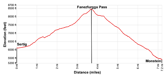
Hike Facts
- Distance: 7.2 - 7.7 miles (one way)
- Elevation: 6,099-ft. - 8,465-ft.
- Elevation Gain: 2,366-ft.
- Difficulty: moderate-strenuous
- Trail Highlights: See Trail Intro
- Basecamp(s): Davos
- Region: Eastern Switzerland
Get off the beaten path with this great hike ascending the Ducan Valley to Fanezfurgga Pass. Highlights include the Ducan Ridge, Ducan Glacier and the Chrachenhorn towering above the head of the Ducan valley. Finish the hike by descending the pretty Oberalp Valley to Monstein.
Sertig to Fanezfurgga to Monstein
The beautiful Sertig Valley, a tributary of the Landwasser Valley, extends southeast through lush pastures with enticing views of the surrounding high peaks. Beyond the last village the valley splits into the Ducan and Chuealp. This hike takes the trail less traveled, ascending the rugged and unspoiled Ducan Valley to Fanezfurgga Pass. Beyond the pass the trail descends the pretty Oberalp Valley to Monstein.
Take the bus from Davos to Sertig Sand (see trailhead directions below). The bus stops in front of the Walserhuus Restaurant/Hotel in Sertig Sand (6,099-ft.). Walk south along the road skirting the east side of the restaurant to a trail signpost, located just beyond the parking lot on the left side of the road. Continue straight ahead on the alp road toward Fanezfurgga, Oberalp and Monstein.
The trail ascends on easy grades through pastures along the east side of the valley. The Sertigbach, a pretty stream, meanders down the idyllic valley beside the trail. Ahead the Mittaghorn, Plattenflue and Piz Duncan, rising along the southeast side of the Ducan Valley, dominate the view.
Reach a “Y” intersection at 0.4 miles. Here we turn right (south) on the trail climbing toward the Ducan Valley. The path to the left (southeast) ascends the Chuealp Valley toward Sertig Pass, Scaletta Pass and Durrboden. See the Sertig Pass hike for more information on this trail.
Our trail crosses a bridge over the Chuealpbach and ascends on easy grades along the east side of the Ducanbach, the stream draining the Ducan Valley. Ahead views open to beautiful Sertig Falls, a photogenic waterfall tumbling 200-ft. down a rugged, rocky chasm in three stages.
At 0.7 miles reach a junction where a spur trail to the falls (Wasserfall) branches right. (The 0.5 mile round-trip detour to the falls is recommended to get good views of this dramatic cascade.) We bear left on the trail toward Fanezfurgga.
Our path ascends steeply through a larch forest and intermittent meadows, climbing up the end of an old terminal moraine at to the foot of the Ducan Valley. At 1.2 miles the grade abates. The trail now travels through meadows to a bridge crossing the Ducanbach to the west side of the valley. The Plattenflue and Piz Ducan soar above the east side of the valley.
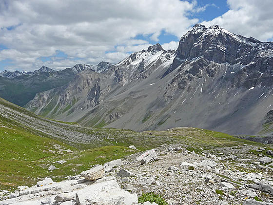
The rugged, untamed glacial valley is sandwiched between the Strel Ridge to the west and the Duncan Ridge, anchored by Piz Ducan, to the east. The trail now curves to the southwest as it climbs steep to moderately-steep grades through rocky meadows and scree slopes along the west side of the valley.
At 1.9 miles the grade lessens and gorgeous views open up the length of the valley to the Chrachenhorn and Ducan Dador at the head of the valley. The Ducan Glacier clings to the slopes between the Ducan Dador and the Chlein Duncan. The saddle on the ridge between the two peaks is the Ducanfurgga, not our pass. The Fanezfurgga, unseen at this point, is located along the valley’s west ridge between the Strel Ridge and Chrachenhorn.
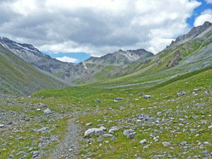
The path now ascends through pretty wildflower-filled meadows on moderately easy grades. At 2.5 miles the grade steepens as the trail angles away from the valley floor and begins climbing the slopes along the west side of the valley. The terrain becomes more rugged as the path ascends through avalanche chutes. Some weird and wonderful rock formations appear along the trail.
Soon the path enters a gully along the base of a lateral moraine and the valley’s western slopes. The path ascends steeply to the head of the gully and then curves to the right, climbing steep switchbacks up the valley's west slopes to exit the gully. Beyond the gully the ascent continues with ever improving views of peaks along the Ducan ridge, the Ducan Glacier and the Ducanfurgga. Ahead views open to the Fanezfurgga. The Strel ridge dominates the view to the north.
At 3.3 miles the grade briefly abates as the path crests a bench and then ascends through meadows and rocky outcroppings to a junction at 3.5 miles. Here a trail branches left to the Ducanfurgga, Stuls and Bergun. We bear right on the trail toward Fanezfurgga, Oberalp and Monstein. The path now climbs steeply to the Fanezfurgga Pass (8,465-ft.) at 3.6 miles.
Sublime views from the pass extend south/southeast to the Ducan Glacier clinging to the rugged slopes between Duncan Dador and Chlein Duncan. The high peaks along the Duncan ridge, anchored by Piz Duncan, dominate the view to the east while the summits rising above the Chuealp Valley are seen to the northeast. A sea of peaks towering above the Davos Valley and beyond fill the skyline to the west. The Chrachenhorn soars above the pass to the southwest while the rugged Strel Ridge and the Alplihorn rise to the northeast.
When you are done admiring the views, follow the trail descending steeply through rocky meadows and scree down the west side of the pass toward Oberalp and Monstein. At 4.0 miles the grade briefly abates as the path passes below the Mitteltalli, a side valley, along the southwest facing flanks of the Alplihorn.
At 4.25 miles the grade steepens as the path drops down pretty meadows beneath the rugged slopes of the Alplihorn to the northeast and the Chrachenhorn to the south. As you descend turn around for great views of the Strel Ridge rising above Fanezfurgga Pass. Ahead are ever improving views of the high peaks rimming the west side of the Davos Valley.
You are now descending above the northeast side of the Oberalpbach, the stream draining the Oberalp valley. Initially the stream is composed of several channels that soon consolidate into a one flow.
At 4.8 miles pass the old wood buildings at Fanezmeder. Turn around here for good views of the Chrachenhorn towering above the head of the valley.
The grade briefly steepens as the path drops down switchbacks and crosses a pretty tributary stream carrying snowmelt from the slopes of the Alplihorn. Beyond the stream the path continues descending on moderately-steep grades. Along the way meadows give way to low shrubs and then scattered larches.
At 6.0 miles reach the hamlet at Oberalp. Here the trail turns into a broad track/road. Travel along the track for a quarter of a mile to a junction. At this point you can either continue down the broad track toward Monstein or turn left, cross the Oberalpbach on a bridge and then descends along a trail on the southwest side of the creek. This trail crosses back over the stream and rejoins the road at 6.7 miles.
Soon the track enters the town of Monstein (5,312-ft.) and arrives at the bus stop at 7.2 miles. Total elevation loss from the pass to the village is 3,153-ft.
Monstein is a pretty village, composed of typical Walser timber houses, some still covered with larch tiles. Along the way you will also see the old grain storage buildings set atop stilts. Thirsty hikers will be interested to know that Monstein is home to one of Europe’s highest breweries. Stop at one of the local restaurants to sample the brew.
Watch your time so you don’t miss your bus back to Davos. Remember that you need to change buses at Glaris on the return to Davos.
Elevation Profile
Driving Directions
Davos to Sertig: From the Bahnhof (train station) at Davos Platz (the southwest end of town), board the bus to Sertig. Purchase a ticket for Sertig Sand, the last stop on the line. The scenic ride up the Sertig Valley takes about 27 minutes. Regularly scheduled buses return to Davos via the same route. A schedule is posted at the bus stop of Sertig Sand. You can also check the current schedules at the SBB website/SBB app.
Note: Buses and trains travel between Davos Dorf and Davos Platz. The train ride takes three minutes. Buses take a variety of routes through the town. Pick up a bus schedule at the Tourism Office at the Davos Dorf Bahnhof or near the Sportzentrum in the middle of town, or consult the SBB website/SBB app to find the stop closest to your accommodations.
From Monstein to Davos: Take the #10 bus from Monstein to the Glaris Bahnhof (train station). At Glaris change for a #1 bus to Davos Postplatz or the Davos Dorf Bahnhof. Check the current schedules at the SBB website/SBB app to determine which stop in Davos is most convenient to your accommodations.
Trail Resources
Trail Intro / Trail Photo Gallery / Trail Map
Basecamp(s) Information:
Davos
Region Information:
Eastern Switzerland
Other Hiking Regions in:
Switzerland