Details: Fuorcla Surlej to Pontresina via Coaz Hut 
Distance: 3.0 - 12.3 miles (one way)
near St Moritz in Eastern Switzerland
Hike Facts
- Distance: 3.0 - 12.3 miles (one way)
- Elevation: 8,855-ft. - 9,039-ft.
- Elevation Gain: 184-ft. - 766-ft.
- Difficulty: strenuous
- Trail Highlights: See Trail Intro
- Basecamp(s): St Moritz
- Region: Eastern Switzerland
Glorious, panoramic views of Piz Bernina and Piz Roseg from Fuorcla Surlej, front row seats to an incredible spectacle of rock and ice from Coaz Hut and a lovely walk through the beautiful meadows and forests of Val Roseg make this one of my favorite hikes in the St. Moritz area.
Trailhead to Fuorcla Surlej
Distance from Trailhead: 3.0 miles (round trip)
Ending/Highest Elevation: 9,039-ft.
Elevation Gain: 327-ft.
Take the bus to Surlej, a small village to the southwest of St. Moritz, and then ride the Corvatsch cable car to the Murtel middle station (8,855-ft.). (See trailhead directions below). From Murtel enjoy splendid views of the Upper Engadine lakes plateau. To the west, Piz d’Emmat Dadaint, Piz Lagrev, Piz Polaschin and the Piz Julier tower above Lake Silvaplana (Silvaplanersee) and Lake Sils (Silsersee), nestled along the valley floor.
At Murtel find the hiking signs outside the lift station and walk in the direction of Fuorcla Surlej (1-hr), Chamanna Coaz (Coaz Hut) (3-hr) and Val Roseg (Roseg Valley) (2-hr 15-min). Follow the trail as it heads southeast, descending gently through an undulating landscape of talus slopes and rocky meadows along the north facing slopes of Piz Murtel. Fuorcla Surlej (Surlej Pass) is visible on the ridge to the east. The top of Piz Tschierva and Piz Boval rise beyond ridge.
At 0.5 miles the trail climbs over the terminal moraine of the Corvatsch Glacier and crosses a few small streams carrying meltwater from the rapidly receding ice sheet. Here views open to the top station for the Corvatsch cable car, situated atop a minor summit overlooking the Corvatsch Glacier. Soon the trail curves to the left (north) and starts climbing on moderate grades toward Fuorcla Surlej. As you ascend, enjoy nice views of the peaks rising along the west side of the Upper Engadine valley.
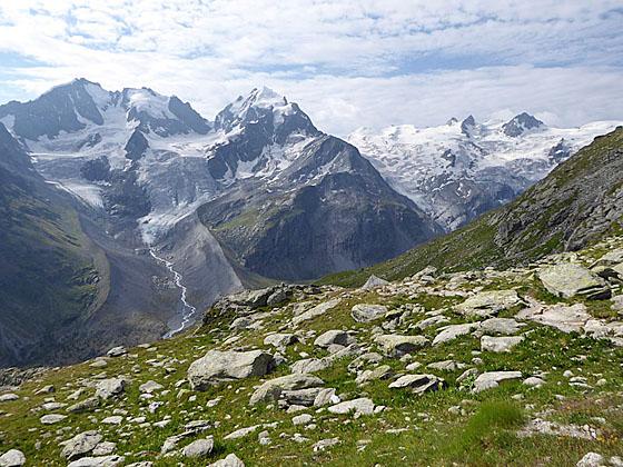
Reach Fuorcla Surlej at 1.5 miles. Here stunning views of Piz Bernina (13,280-ft.) and Piz Roseg (12,916-ft.), soaring above the east side of Val Roseg, burst onto the scene. The Tschierva Glacier cascades down the west face of the peaks. Piz Sella and Piz Gluschaint tower above the head of the valley blanketed by the Sella and Roseg glaciers. Berghaus Fuorcla Surlej, a restaurant, is located at the pass along with a small photogenic lake. The pass is a great destination for parties looking for a short, highly scenic hike.
Fuorcla Surlej to the Viewpoint or Coaz Hut
Distance from Trailhead: 4.1 miles (one way)
Ending/Highest Elevation: 8,710-ft.
Elevation Gain: 766-ft.
When you are done soaking in the views, hike southeast on the trail toward Chamanna Coaz (Coaz Hut), Val Roseg and Puntraschigna (the Romansh spelling of Pontresina). The path descends on moderate grades along the west side of Val Roseg, passing a junction at 1.7 miles with a trail branching left (northeast) toward Pontresina. Our trail bears right toward Coaz Hut, traveling through pretty meadows with every improving views of valley’s high peaks and glaciers. After crossing a pretty stream at 2.4 miles the trail curves to the south and climbs briefly before continuing its descent on moderate to moderately steep grades.
Soon the trail crosses another small stream below a lovely waterfall and then begins a traverse across a broad avalanche chute. At 2.7 miles rocks block the continuation of the trail. Turn left here, following a detour on a trail that switchbacks down the hillside along the north side a stream for 0.1 miles to a junction. Ignore the trail branching left toward Alp Ota and Pontresina. Instead turn right toward Coaz Hut on a path that crosses a wood bridge over the stream.
Past the bridge the detour climbs steeply up the hillside for a short distance and turns left, rejoining the original trail at 3.0 miles. The path now ascends on easy grades along the west side of the valley. At 3.4 miles pass a junction with a closed trail branching left.
Beyond the junction our trail curves to the southwest as it travels through pretty meadows with splendid views of the Bernina peaks, including Piz Sella and Piz Gluschaint anchoring the glacier-clad cirque at the head of the valley. Piz Bernina and Piz Roseg rise directly across the valley. The milky glacial waters of Lej da Vadret (Lake Vadret) lie cradled on the valley floor.
Beyond this point hikers need to make a decision to go all the way to Coaz Hut on an out-and-back hike or continue to Pontresina by heading down the Roseg Valley. Visiting the hut and then continuing to Pontresina is too long for most hikers to accomplish in a day. (We advise a two day trip with an overnight stay at the hut.)
Out-and-Back Hike to Coaz Hut
To visit the hut on an out-and-back hike, continue ascending along the trail on moderate grades. At 4.5 miles the trail starts descending on easy grades. As the path nears the head of the valley at 5.3 miles it curves to the left (southeast), traveling through rocky meadows that give way to scree covered slopes strewn with large boulders.
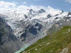
Soon the trail drops through a landscape of rock slabs, reaching Coaz Hut (8,563-ft.) at 5.7 miles. The hut, situated on a rocky knob beneath the Roseg Glacier, enjoys amazing views of the Roseg and Stella glaciers tumbling down the valley’s head wall. To the north views extend down the length of Val Roseg. Behind the hut a use trail climbs a moraine wall for a bird’s-eye-views of the hut and the glaciers.
When you are ready to head back, retrace your steps to Murtel for an 11.4 mile round-trip hike and then take the cable car down to Surlej.
Hiking to the Viewpoint
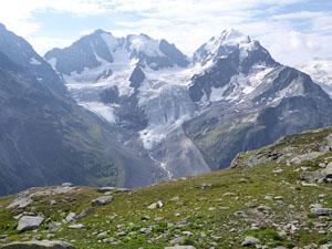
Hikers preferring to return via Val Roseg to Pontresina should not attempt to reach the hut but instead find a comfortable perch along the trail. My favorite spot is at 4.1 miles where the grade abates as the trail traverses a grassy bench. Large, flat rocks offer great perches for enjoying a picnic lunch while soaking in the dramatic views of the glacier-clad cirque at the head of Val Roseg. Across the valley Piz Bernina and Piz Roseg dominate the view.
Viewpoint to Pontresina
Distance from Trailhead: 12.3 miles (one way)
Ending/Highest Elevation: 5,830-ft.
Elevation Gain: -2,880-ft.
To continue to Pontresina via Val Roseg, turn around and follow the trail as it descends on easy grades, passing the blocked junction at 4.8 miles. Bear right at the detour at 5.2 miles. Follow the trail for 0.2 miles as it descends on steep grades and then crosses the wood bridge over the stream. At the trail junction beyond the bridge take the trail branching right toward Alp Ota, Roseg and Puntraschigna (Pontresina). The trail to the left climbs to Fuorcla Surlej and back to Murtel (the middle station on the Corvatsch cable car) in 2.8 miles for an 8.2 mile round-trip hike.
The trail to Pontresina descends on steep switchbacks to the valley floor and a junction at 7.0 miles, accompanied by great views of the high peaks. Along the way pass the buildings of Alp Surovel at 6.2 miles.
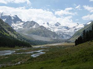
At the junction a trail ascends south along the valley floor toward Coaz Hut. Our trail heads northeast, descending on easy grades along the west side of Val Roseg toward Roseg and Puntraschigna. The Ova da Roseg (Roseg River) flows down the valley to your right. Be sure to turn around for lovely views of peaks, cloaked in glaciers, towering above the head of the valley.
Pass the Hotel Roseggletscher (Hotel Roseg Glacier) (6,558-ft.) at 7.8 miles. Beyond the hotel take the broad path branching right toward Puntraschigna (1-hr 45-min). (The trail to the left climbs to Fuorcla Surlej.)
At 8.0 miles cross a bridge over the Ova da Roseg (stream). On the east side of the valley the path turns left (northeast) and briefly travels along a dirt road shared by walkers, horse carriages and bikes. At 8.5 miles leave the road by taking the trail designated for walkers branching right.
The walker's trail down the valley is lovely, traveling through meadows and clusters of larch and pine trees on the right (east) side of the valley. Along the way follow the signs to the Pontresina train station.
At 10 miles the trail enters the trees. Turn left (west) when you reach a paved road at 12 miles and walk a quarter mile to the Pontresina Train Station (5,830-ft.) where you can catch a train or a bus back to St. Moritz. (See directions below). The village of Pontresina is located across the Flax River on the north side of the Bernina Valley. Total distance for the hike is 12.3 miles.
Note: From Coaz Hut there is an alternative trail that heads down the Roseg Valley. From the hut follow the trail toward Fuorcla Surlej for 0.7 miles to a junction with a trail that drops steeply down to the Lej da Vadret. The trail then travels along the west side of the lake and eventually joins with the main trail heading toward Hotel Roseg. Total distance from Coaz Hut to Pontresina via this route is 9.4 miles.
In my opinion the high trail back to Pontresina, accessed after the detour, is more scenic. Hiker choosing to do an out and back hike to Coaz Hut from Pontresina will want to take the high route out and the low route back for variety. The length of this trip will require an overnight stay in the hut. Total distance for the loop is 19 miles.
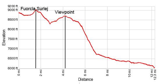
Elevation Profile
Driving Directions
St. Moritz to Corvatsch Cable Car in Surlej: In St. Moritz board a #6 bus bound for Sils/Segl Maria, Posta or a #1 bus for Surlej, Corvatschbahn and get off at the Corvatschbahn (Corvatsch Cable Car) station in Surlej. (Visit the St. Moritz tourism office to get a bus map, the Engadin Bus site for route maps/schedules or the SBB Website/SBB App to determine the stop closest to your accommodations.) The bus ride will take between 20-40 minutes depending on the connections. (Note: You may need to change buses.) At Corvatsch, purchase a ticket to Murtel, the middle station for the cable way.
Pontresina Bahnhof (train station) to St. Moritz: At the train station, take the train to St. Moritz, a 12 minute ride, or take the #1 bus in the direction of Surlej, Corvatschbahn and get off at the stop in St. Moritz that is closest to your accommodation. The ride to the center of St. Moritz takes about 13 minutes. See the SBB Website or the SBB App for the current train and bus schedules.
Trail Resources
Trail Intro / Trail Photo Gallery / Trail Map
Basecamp(s) Information:
St Moritz
Region Information:
Eastern Switzerland
Other Hiking Regions in:
Switzerland