Details: Gorner Gletschertor and Gletschergarten 
Distance: 3.8 - 5.9 miles (one way)
near Zermatt in The Valais
Hike Facts
- Distance: 3.8 - 5.9 miles (one way)
- Elevation: 6,125-ft. - 6,890-ft.
- Elevation Gain: 900-ft.
- Difficulty: moderate
- Trail Highlights: See Trail Intro
- Basecamp(s): Zermatt
- Region: The Valais
This trail ascends through larch forests and rocky meadows in the lower Gorner Valley, exploring the rugged terrain left by the receding Gorner Glacier. Information boards show the glacier’s progress over time and provide insights on the area’s geology.
Gorner Gletschertor
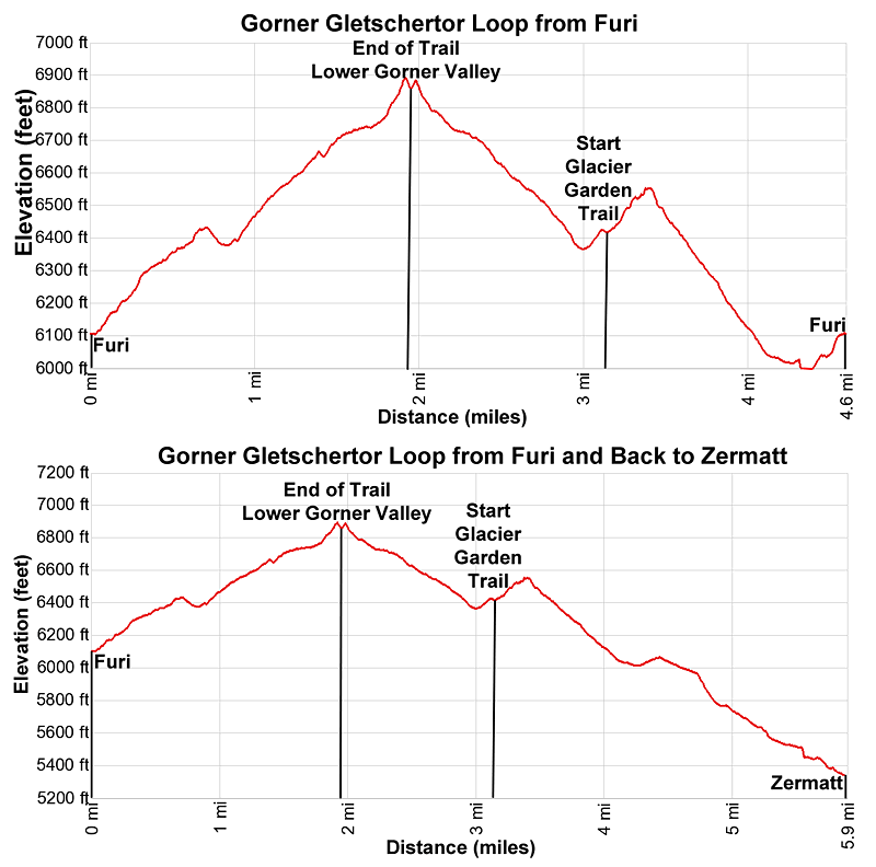
Furi - Gletschertor (RT): 3.8 miles (6.1 km)
Elevation gain/loss: +/- 900-ft.
Furi - Gletschertor (Loop): 4.6 Miles (7.4 km)
Elevation gain/loss: +/- 1150-ft (351-meter)
Furi – Gletschertor – Zermatt (One-Way): 5.9 miles (9.5km)
Elevation gain/loss: +1050-ft / -1800-ft (+320/-545-meters)
The Gorner Gletschertor hike starts at the Furi Lift station, reached via the Schwarzsee Gondola. (See hiking directions below). From Zermatt the Schwarzsee gondola travels through several intermediate stations. Furi is the first. Be sure to get off here when the gondola doors open. The gondola will continue beyond Furi to Schwarzee, Furgg and Trockener Steg.
Exit the Furi gondola station and walk a short distance to the trail signs. Here signs for the Gletschergarten (35 min) and the Gletschertor (1hr 10min) point right (west/northwest). The path ascends through pastures, passing a few houses to a signed junction. Turn left (south/southwest) to continue toward the Gletschergarten and the Gletschertor.
The path now ascends on moderate grades through meadows and then trees, passing a few junctions. At all intersections stay on the Gletschertor path.
At 0.4 miles (0.6 km) reach a junction at the former location of the Im Boden alp. In 1840 the site was home to over a dozen stables and mountain huts. Two years later the site was engulfed by the advancing Gorner Glacier.
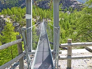
Past Im Boden the path curves to the left (south/southeast) and crosses a swing bridge spanning the deep, narrow gorge carved by the Gornera, the stream carrying glacial meltwater from the Gorner Glacier. On the other side of the bridge the trail ascends through trees and then a playground and picnic area before arriving at a junction at 0.7 miles (1.1-km). To the left is the trail to the Gletschergarten (Glacier Garden). We will save that for the return trip. For now, turn right on the Gletschertor trail.
The broad path briefly descends as it heads southwest through trees and the turns left (south/southeast), curving around the end of the Gornergrat, the Gorner Ridge. At 0.9 miles (1.4 km) reach a junction with a cement/metal bridge spanning the gorge carrying the Gornera. The bridge, located above the confluence of the Gornera and the Furggbach (Furgg stream), marks the end of snout of the retreating Gorner Glacier in 1928. Take a detour onto the bridge for great views of the gorge and the stream flowing down the rocky chasm. When you are done enjoying the views, return to the Gletschertor Trail.
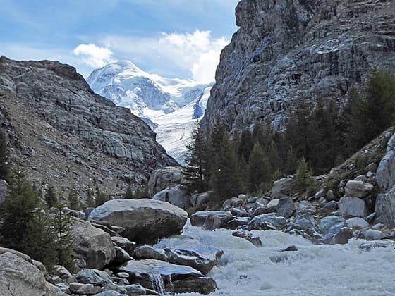
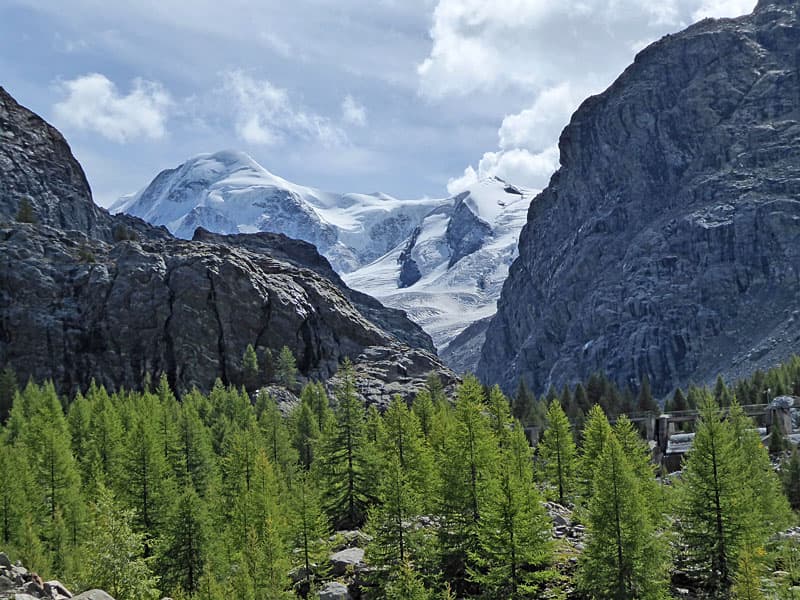
Past the bridge the Gletschertor path ascends on easy grades as it curves around the cliffs at the foot of the Gornergrat. Here views stretch up the length of the lower Gorner valley. Ahead the ice-clad summits of Lyskamm and Pollux tower about a "V" shaped gap in the valley. The gap marks the beginning of the upper Gorner Valley.
The tongue of the Gorner Glacier use to spill down the headwall beneath the gap separating the upper and lower valley. Here the Gletschertor (Glacier Gate), the point where the glacial stream emerges from the snout, was also visible. Today the tongue and the glacier gate are now located in the upper valley and can no longer be seen from the trail.
At 1.1 miles (1.8-km) pass a junction with a trail branching left toward the Gletschergaten. This trail, an alternate approach to the garden, climbs a series of very steep steps up a rugged rock face. This path is not recommended for small children. The better option is to take the trail near the playground.
The path now ascends along the east side of the valley, traveling through scattered larches and Swiss stone pines growing amid the rocky debris left by the retreating glacier. At 1.3 miles the trail approaches a spillway and intake for a hydroelectric system. Here much of the water in the Gornera is redirected into the intake for the system, greatly reducing the volume of water downstream of the spillway. On the upstream side of the intake, we now see the full force of the Gornera thundering down the valley floor.
The trail briefly travels along the gushing torrent and then moves away from the stream as it continues up the east side of the valley through scattered trees set amid rocky meadows and scree covered slopes. Along the way enjoy views of the ice-clad summits rising above the upper valley. The cliffs beneath the Gornergrat plateau rim the valley to the east.
At 1.6 miles reach a junction where the Gletschergartenweg (Glacier Garden Path) branches left and climbs steeply to Riffelalp and Riffelberg. We continue up the lower Gorner Valley on the Gletschertor trail. A sign, a short distance beyond the junction, marks the end of the glacier tongue in 1946.
At 1.7 miles reach a split in the trail. The left branch, the main trail, is marked with the red and white slashes on rocks. The right branch, the old trail, is blocked by a tree branch. A little way up the valley the two trails meet. It is not clear how much longer the old trail will exist. During periods of highwater the Gornera is eroding the banks along the stream and will eventually destroy the path.
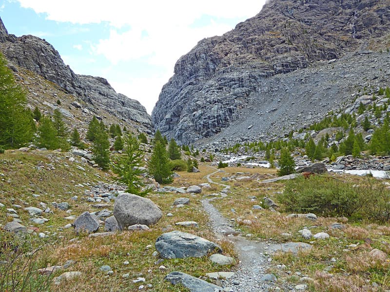
The trail now wanders up the valley, passing small trees and low bushes set amid rocky meadows. The Gornera, a thundering torrent, spills down the rocky stream bed. Turn around for fine views of the Ober Gabelhorn, the Wellenkuppe and the Zinalrothorn, along with nearby summits, towering above the Hohbalm plateau to the northwest.
At 1.8 miles the old path and the main trail meet. Continue up valley along the main trail. You will now see use trails branching off to the right and heading down to the stream. Exercise care if you go closer to the stream and be sure to keep children away from the raging torrent.
The trail essentially ends at 1.9 miles. Sure-footed hikers can get a better view of the Gornera gushing down the gap between the upper and lower valley by climbing down through a boulder field to the shore of the stream. Use caution and common sense if you opt for a closer view.
The end of the trail is a great place to look back at the high, jagged peaks rising above the Hohbalm. When you are done taking in the views retrace you steps to the junction at the playground and picnic area at 3.1 miles (5.0-km).
Here we have three choices to complete the hike. The easiest and shortest option is to return the way you came, crossing back over the swing bridge to Furi for a 3.8 miles (6.1-km) hike. Alternatively add a side trip to the Gletschergarten (Glacier Garden) and then return to Furi or Zermatt by following Gletschergartenweg as it descends along the east side of the Gornera.
To visit the Gletschergaten and/or continue to Furi or Zermatt via the Gletschergartenweg, continue straight ahead along the broad track toward the Gletschergarten. At 3.2 miles (5.1-km) reach a junction. Turn right to visit the Gletschergarten. If time and energy allow the side trip is worthwhile. Otherwise, continue straight ahead toward Furi and Zermatt.
To the Gletschergarten (Glacier Garden)
The trail to the Gletschergarten makes a short, steep climb to a flat, open area beneath a cliff. This area is part of the hydro project. Look left and you will see a wood arch marking the start of the Gletschergarten loop. The area was discovered by Yvo Biner, a hotel manager, in 1966. He excavated and landscaped the site, opening it to the public in 1974. Information panels along the trail describe the geological features.
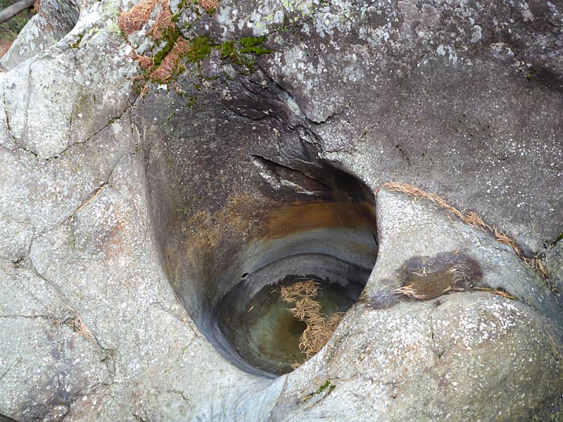
The path initially ascends through trees, passing the first of several glacial potholes, cup-shaped depression formed by swirling glacial meltwater, and then comes to the entrance to a soapstone quarry, believed to have been mined during the Middle Ages. A sign midway along the loop points to a boulder set atop the stump of a larch tree that lived from 1453 to 1623. During a period of glacier advance in the 17th century local people cut down trees, including this larch, to save the valuable lumber before it was engulfed by the advancing glacier. As the glacier approached the furthest point of its advance in about 1667, it deposited a boulder atop the stump.
We see more potholes as the trail descends back to the start of the loop. Wood ramps facilitate the climb to see some of the potholes while fencing blocks passage to steep drop offs. Use caution when the area is wet, the wood can be very slippery. Keep a hold of small children. The safe guards are easily surpassed by inquisitive kids hoping to get a closer look.
Soon the loop trail returns to the arched gateway for the garden. From here descend to the junction with the paths heading back to Furi and Zermatt at 3.6 miles. (From here you can also opt to return to Furi via the swing bridge for a 4.3 mile (6.9-km) day.)
Return to Furi along the Gletschergartenweg
After the side trip to the Gletschergarten, turn right at the junction on the Gletschergartenweg toward Furi and Zermatt. The path now descends on steep to moderately-steep switchbacks through trees along the slopes to the east of the Gornera. At 4.1 miles a sign marks the location of the former hamlet of Zer Bruggu, engulfed by the advancing glacier in 1851.
Beyond the sign the trail follows an undulating course as it drops town to an intersection at 4.4 miles (7.1-km). Here the Gletschergarteweg and the trail to Furi turn left and quickly crosses a bridge over the Gornera. Beyond the bridge the path ascends a broad track to the Furi lift station at 4.6-miles (7.4-km).
Return to Zermatt
To walk back to Zermatt, at the intersection at 4.4 miles, bear right on the trail to Winkelmatten and Zermatt. You are now sharing a track used by bikes. The trail continues its descent on easy to moderately-steep grades through trees and meadows. At all intersections take the trail toward Zermatt and Winkelmatten. There are a few places where signs point to hiker only trails that briefly leave the broad track to short-cut switchbacks.
At 5.3 miles (8.5-km) the broad track reaches the outskirts of Zermatt, crosses a bridge over the Findelbach to Winkelmatten. Here signs point to various destinations in Zermatt, including the valley station for the Schwarzsee Gondola where this description ends at 5.9 miles (9.5-km). From here reverse the trailhead direction to reach the Zermatt Bahnhof (add 0.4 miles/0.6 km) or retrace your steps to your accommodations in Zermatt.
Elevation Profile
Driving Directions
Walking Directions from the Zermatt Bahnhof (Train Station) to the Schwarzsee Lift Station: Walk south/southwest on Bahnhofstrasse, the town's main street, for 0.3 miles (0.5 km) and then turn left onto Kirchstrasse (Church Street). You will pass the Matterhorn Museum on the left just before the turn. The Pfarrkirche St. Mauritius (church) is located on the southeast corner of Bahnhofstrasse and Kirchstrasse.)
Walk down Kirchstrasse for 0.1 miles (0.2 km), crossing the bridge over the river, and then turn right on Schluhmattstrasse (Schluhmatt Street), the first street past the river. Follow Schluhmattstrasse for 0.4 miles (0.6-km) to the Matterhorn Glacier Paradise / Schwarzsee Gondola Station.
When purchasing lift tickets be sure to tell the agent you are doing the hike so you can purchase a combination ticket that takes you from Zermatt to Trockener Steg and then from Schwarzsee to Zermatt. The other option is to purchase a ticket to the Matterhorn Glacier Paradise, visit the Matterhorn Paradise in the early morning and then on the way back down get off a Trockener Steg and do the hike. For more information see the Schwarzsee Gondola Information on the Matterhorn Paradise lift pages.
Trail Resources
Trail Intro / Trail Photo Gallery / Trail Map
Basecamp(s) Information:
Zermatt
Region Information:
The Valais
Other Hiking Regions in:
Switzerland