Details: The Windows and Double Arch 
Distance: 0.5 - 2.0 miles (loop)
Arches National Park, near Arches in Southeast Utah
Hike Facts
- Distance: 0.5 - 2.0 miles (loop)
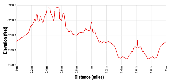
- Elevation: 5,125-ft. - 5,270-ft.
- Elevation Gain: 145-ft.
- Difficulty: easy
- Trail Highlights: See Trail Intro
- Basecamp(s): Arches / Moab
- Region: Southeast Utah
A photographer’s delight, this trail visits North Window, South Window, Turret Arch, and Double Arch, features great views of the areas distinctive rock formations and includes distant vistas of the La Sal Mountains.
The Windows and Double Arch
0.7 mile loop – The Windows (North and South Windows plus Turret Arch) 1.2 mile loop – The Windows and the Primitive Loop 0.5 miles RT – Double Arch 2.0 mile loop – The Windows, the Primitive Trail and Double Arch (includes the short trail linking the two areas)
The Windows Road is a spur road off the Arches Scenic Drive (see driving directions below). At the end of the Windows Road is a one-way loop with two parking lots. One lot is directly in front of the North Window and the other is by Double Arch. This hiking description assumes you park by the North Window. The two lots are linked by a short (0.15-mile) trail cutting through the loop. Alternatively, you can walk between the two sites on the sidewalk (.17-miles) alongside the loop road.
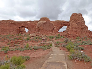
The North and South Windows, also known as the Spectacle, are the two side-by-side arches are separated by a large sandstone “nose.” The arches were created by the erosion of a huge sandstone fin over 100-ft. wide.
From the Windows parking lot, follow a paved path ascending on easy grades toward the North Window. Turn around for good views of the Double Arch formation to the northwest.
In 0.1-miles reach a “Y” intersection. The trail branching right leads to Turret Arch while the trail to the left goes to the North Window. Bear right, walking 0.1-miles to Turret Arch (35-ft wide by 65-ft high). A tower and a small window rise to the left of the arch. For a closer look, follow the dirt trail to the base of the arch and then climb through the arch.
Return to the main trail and head toward the North Window, passing a junction for the trail to the South Window. It’s an easy climb to the North Window’s 90-wide opening. From here you have great views of Turret Arch and the surrounding area.
After admiring the North Window retrace your steps to the junction and turn south on the trail to the South Window. The paved trail ends at the viewpoint for this interesting arch. Most people visiting the Windows turn around at this point and return to the parking area. I strongly recommend continuing the hike along the “primitive trail,” a dirt track that starts at this viewpoint.
Calling this trail primitive is not accurate. The trail is easy to follow and family-friendly. Past the viewpoint the primitive trail descends on easy grades, curving around the backside of the fin containing the North and South Windows. You now leave the crowds behind and get a taste for Arches’ backcountry, traveling through a high desert landscape populated by stunted pinyon pines, junipers, greasewood and Mormon tea bushes growing amid bedrock outcroppings.
The back of the fin offers a different perspective of the North and South Windows along with views of nearby rock formations. To the south and east two canyons, cut by the Colorado River and Salt Creek, wind their way through the fractured landscape. In the distance, the La Sal Mountains dominate the view to the southeast while sandstone towers and cliffs rise beyond the canyons to the east.
After walking a little over a half mile, the primitive trail turns back to the west as it climbs around the north end of the fin. Here views open to Double Arch and the Parade of Elephants, a nearby rock formation. The trail now crosses a bench covered with scrub growth, reaching the parking lot in 0.2 miles. Total distance for the hike so far is 1.2 miles.
Double Arch
To reach Double Arch from the Windows parking area, cross the loop road. At the west end of the Windows parking lot take the trail cutting through the loop to the Double Arch Parking area. Alternatively, follow the sidewalk along the side of the loop road (north/northwest) to the start of the Double Arch trail.
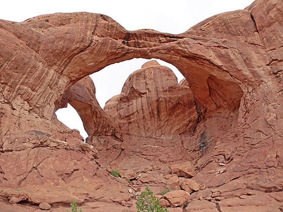
The gravel-surfaced Double Arch trail rises gently to the base of two immense arches. The formation is an excellent example of a Pothole Arch, formed when water collects in a natural depression. A process of chemical weathering eventually cuts through the layer of rock, forming an opening. The larger of the two spans is the third largest arch in the park measuring 144-ft. wide by 112-ft. high. The smaller opening is 67-ft. wide and 86-ft. high.
Climb up into the arches for a different perspective. From the inside of the formation, the larger span frames a scenic view of the surrounding area. When you are done explore Double Arch, retrace your steps to your vehicle for a 2.0 miles round-trip hike. If parked in the Double Arch parking lot, the hike to Double Arch and back is 0.5 mile or 0.8 miles if walking from the Windows parking area.
Elevation Profile
Driving Directions
From Moab, UT: From Center Street and Main Street/US 191 in Moab, head north on Main Street/US 191 N for 4.6 miles and then turn right on the Arches Entrance Road. Pass thru the kiosk where you pay your entrance fee. A short distance beyond the kiosk is the right turn for the Visitor Center. The Visitor Center is a good place to see exhibits on the park, obtain information and check on current conditions.
Beyond the Visitor Center follow the road, now called the Arches Scenic Drive, for 9.9 miles and then turn right on the Windows Road. Drive 2.4 miles to the end of the Windows Road. Here you will find a loop with two parking areas, one in front of the Windows and the second by Double Arch. The Windows Section of the Park is very popular and the parking areas regularly fill to capacity. The best strategy is to visit the area in the early morning or later in the afternoon.
Trail Resources
Trail Intro / Trail Photo Gallery / Trail Map
Basecamp(s) Information:
Arches / Moab
Region Information:
Southeast Utah
Other Hiking Regions in:
Utah