Details: Bullet Canyon 
Distance: 11.5 - 15.8 miles (round trip)
Grand Gulch Primitive Area, BLM, Monticello, Utah office, near Blanding in Southeast Utah
Hike Facts
- Distance: 11.5 - 15.8 miles (round trip)
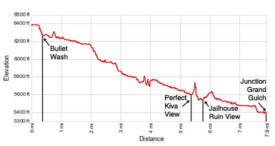
- Elevation: 6,408-ft. - 5,370-ft.
- Elevation Gain: -1,038-ft.
- Difficulty: strenuous
- Trail Highlights: See Trail Intro
- Basecamp(s): Blanding / Grand Gulch
- Region: Southeast Utah
This strenuous hike leads to two fascinating ruins, Perfect Kiva and Jailhouse Ruin, in scenic Bullet Canyon. Past the ruins the trail continues down canyon to the confluence with Grand Gulch.
To Perfect Kiva and Jailhouse Ruins
Distance from Trailhead: 11.5 miles (round trip)
Ending/Highest Elevation: 5,582-ft.
Elevation Gain: -826-ft.
Note: The mileage in this hiking description includes side trips.
The trailhead for Bullet Canyon is located down a spur road off UT-261, 7.1 miles south of the Kane Gulch Ranger Station. (See the driving directions below for more information.) The trail starts on the west side of the parking lot to the left of a large bulletin board.
Follow the trail as it heads west across the mesa for 0.25 miles to the rim of Bullet Canyon and then descends steeply down a series of slickrock ledges to the canyon floor, 0.4 miles from the trailhead. Three rock cairns in the wash mark were the trail turns to climb to the rim. Hikers doing an out-and-back trip should make note of the rock cairns to know where to exit the canyon on the return leg of the journey.
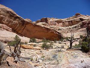
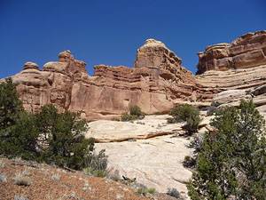
Initially the multi-hued canyon walls are quite low but will rise in stature. Pinyon pines, junipers and desert shrubs grow amid the sandstone slabs along the canyon’s walls and on the benches lining the wash.
Proceed down the drainage along the wash for a short distance. Soon you will see a trail heading up the bench on the right (north) side of the wash. Over the course of the hike the trail will frequently leave the wash and traverse boot beaten paths across benches to cutoff meanders, navigate pour-offs and avoid obstacles in the wash.
Providing exact turn by turn directions of the route down the drainage is impossible. Seasonal floods will render some bypasses unusable and create the need for new detours. In general it is best to follow the bypass trails across the benches, especially if marked by rock cairns, as opposed to slogging down the sandy wash or climbing around/over obstacles.
At 1.6 miles the trail skirts a minor pour-off by traversing the slickrock bench along the right (north) side of the canyon. Just beyond is a major pour-off where the drainage drops down a series of steep chutes. Follow the trail, marked by rock cairn, as it traverses slickrock ledges above the right (north) side of the chute. Watch carefully for cairns marking where the route drops down ledges and steep friction pitches to the canyon floor. Backpackers may feel more comfortable using ropes to lower their packs down a few of the ledges.
If there is no water in the wash it is possible to descend sections of the chute. Avoid climbing down wet or icy slickrock when navigating the chute. Wet slickrock is amazingly slippery.
As you descend, take time to admire the pour-off’s sculpted chutes set beneath the canyon’s sheer walls decorated with desert varnish. Desert varnish is the thin red to black coating found on the exposed rock surfaces in the canyon. It’s composed of clay minerals, oxides and hydroxides of manganese and/or iron, as well as other particles. The color depends upon the relative amounts of manganese and iron. Manganese-rich varnishes are black; manganese-poor, iron-rich varnishes are red to orange; those intermediate in composition are usually a shade of brown.
Past the major pour-off the trail weaves its way along a constricted section of the rocky canyon floor, choked with brush. At 2.4 miles a massive, impassable boulder jam in the wash forces the trail to steeply ascend the bench on the right (north) side of the canyon to a ledge. A cairned trail, with a bird’s-eye view of the canyon, travels along the ledge for 0.2 miles.
At the end of the ledge the trail drops steeply down rocky switchbacks to the wash. Out-and-back hikers should make note of where the bypass re-enters the wash amid a thick patch of willows so as not to miss the turn on the return leg of the hike.
Continue down canyon, zigzagging between the rocky wash and its adjacent benches. Steep, water chiseled drainages, side canyons and amphitheaters soon interrupt the sheer canyon walls, adding interest to the walk.
At 4.2 miles the canyon widens and the way becomes easier as the trail traverses wide grassy benches scattered with pockets of pinyon pines and junipers. The large open areas offer great views of the sculpted canyon walls topped by oddly shaped knobs and fins.
At 5.2 miles the trail rounds a bend in the canyon and views open to a large alcove about midway up the north wall of a side canyon. If you look carefully you will see ruins. This is Perfect Kiva, a well preserved Ancestral Puebloan ruin.
I highly recommend the 0.3 miles side trip to Perfect Kiva. To visit the ruins watch for a trail heading right (northeast) into the canyon at 5.3 miles. Follow the trail as it enters the side drainage and soon starts climbing ledges and slickrock slopes to the alcove. A few rock cairns mark the way.
The alcove houses a number of ruins including its namesake kiva along with several rock art panels. It is amazing that the original roof of the kiva is still intact. The BLM installed a new ladder and allows hikers to visit the interior of the kiva. Step gingerly on the roof when entering the structure. Do not touch any of the ruins or rock art in the alcove and take care not to disturb the artifacts, such as pot shards and corn husks, found around the site.
From the alcove enjoy expansive views up canyon. On a hot day the shady alcove is a welcome refuge from the sun.
Please be careful when visiting Perfect Kiva and other archaeology sites. Do not sit, climb or step on the walls of any structures or attempt to enter the structures, unless specifically permitted. Do not touch the rock art. See the note at the bottom of this article on the proper etiquette when visiting these sites.
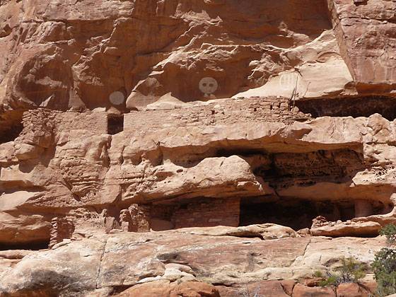
After you are done exploring Perfect Kiva return to the trail and continue down canyon on the bench along the south side of the wash. Soon the trail crosses the wash and climbs to the bench on the north side of the canyon. Follow the trail across the bench. At 5.5 miles views open to Jail House ruin, a multi-level ruin located on the on the north wall near the mouth of the next side canyon.
Jailhouse ruin, named for the wood lattice window in one of the structures, is built on two levels. Above the structures on the top level is a fascinating rock art panel featuring three large, white circular pictographs. The first image is a solid white circle, the second image is drawn with what appears to be two eyes and the third is outlined in white and contains three vertical white stripes.
The lower level alcove includes two small structure providing excellent examples of the mud-and-wattle construction techniques. Along the back wall of the alcove are a few pictographs. Other rock art is located adjacent the white circles on the upper level. One unusual aspect of the site is the highly eroded, honeycomb walls around the ruins.
Jailhouse ruin is a good turn around point for day hikers. Backpackers will find some nice campsites in the vicinity. Jailhouse Spring, one of the more reliable springs in Grand Gulch, is located 0.2 miles down canyon from the ruin. Check at the Kane Gulch Ranger station before starting your hike to determine the availability of water in the canyon.
To Grand Gulch
Distance from Trailhead: 15.8 miles (round trip)
Ending/Highest Elevation: 5,370-ft.
Elevation Gain: -1,038-ft.
Beyond Jailhouse the trail travels down canyon along the rocky wash and its adjacent benches to the confluence with Grand Gulch, 7.9 miles from the trailhead (with side trips or 7.2 miles from the trailhead without side trips). There are good campsites at the mouth of Bullet Canyon amid the Cottonwoods. In the spring the wash in Grand Gulch at the mouth of Bullet Canyon typically contains water from seasonal Bullet Junction Spring. Again, check at the Kane Gulch Ranger Station before setting out to obtain information on current water conditions.
Note: Net elevation gain/loss much greater than the simple difference between the elevation at the trailhead and the end point. There is a lot of up and down on this hike!!
Water Availability in Grand Gulch
Backpackers should always check at the Kane Gulch ranger station on water availability. Water conditions vary depending on the time of year. During any time of year water conditions can vary from week to week.
Most springs are dry during the summer months. During this period you may need to pack in all of your drinking water. Recommended minimums are 1 gallon per person per day. During and after heavy rains, springs can be covered by silt saturated flood water. The most reliable springs in Grand Gulch are Todie Spring, Sheiks Spring, and Jailhouse Spring in Bullet Canyon.
A note about visiting archaeology sites:
Grand Gulch was occupied by Ancestral Puebloan Native Americans between 800 and 2,000 years ago. Ruins from this period may be found built in protected areas such as under overhangs and in alcoves in the cliffs. Their rock art decorates cliff faces and protected alcoves.
Unfortunately this fascinating record of the past is threatened. The unintentional damage caused by visitors is slowly destroying the remnants of the ancient culture. These resources are nonrenewable. Before entering an archeological site, take a few moments to plan your "exploration strategy" to ensure that your visit results in a minimum impact.
Climbing on roofs and walls can destroy in a moment what has lasted for hundreds of years. Do not lean on or climb on walls or roofs or enter any rooms. Please respect all chain barriers. Use extra care around plastered walls. Leave your backpack outside of the site. A bump with a backpack can easily break or chip the plaster.
When you see potsherds and other artifacts leave them where they are. If each visitor took just one, there would soon be none left. Putting them into piles for display takes them out of context, exposes them to weather, and destroys clues needed by professional archeologists gathering information about the site. Please do not reuse prehistoric grinding stones or surfaces.
Enjoy rock art by viewing, sketching, and photographing it. Never chalk, trace, or otherwise touch rock art. Any kind of direct contact causes these ancient figures to disintegrate. Do not add your name or any other modern day rock art.
Please stay out of the trash! A midden is a trash pile left by the original occupants of the site. It is usually recognized by darkened soil and perhaps a slightly raised area in front of the site. Do not walk through the midden. This can destroy valuable archeological information and causes erosion which may undermine the walls of the structures above it. If a trail has been built across a site, stay on it. Please respect any area marked as closed to entry, or physically closed to entry.
Take only pictures, and leave only footprints.
Elevation Profile
Driving Directions
From Blanding: Drive south on US 191 S for 4 miles and turn right (west) on UT-95 N. Follow UT-95 for 28.4 miles and turn left (south) on UT-261 S. Head south on UT 261 for 11 miles and turn right (west) on the road to Bullet Canyon, located between mile posts 21 and 22. The turn is 7.1 miles south of the Kane Gulch Ranger Station. There is a BLM sign setback from the highway marking the road to Bullet Canyon. Follow the dirt road (County Road 251) for 1.2 miles to the trailhead.
From Mexican Hat: Head north on US-163 for 3.9 miles and turn left (north) on UT-261 N. Follow UT-261 north for 21.7 miles and turn left (west) on the road to Bullet Canyon, located between mile posts 22 and 21. Note: a short section of UT-261 climbs steep gravel switchback up the Moki Dugway. There is a BLM sign setback from the highway marking the road to Bullet Canyon. Follow the dirt road (County Road 251) for 1.2 miles to the trailhead.
Trail Resources
Trail Intro / Trail Photo Gallery / Trail Map
Basecamp(s) Information:
Blanding / Grand Gulch
Region Information:
Southeast Utah
Other Hiking Regions in:
Utah