Best Hikes in Bears Ears NM, Utah
Location: Southeast Utah
On US-191, 75 miles south of Moab, UT, 125 mile northwest of Durango, Colorado and 188 miles southwest of Grand Junction, Colorado.
Bears Ears NM Hiking Trails
Distance: 3.2 - 5.6 miles (Round Trip)
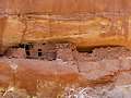
Moon House, one of the best archaeology sites on Cedar Mesa, consists of three separate structures with 49 rooms. Well preserved pictorgraphs grace the walls of an interior courtyard and some of the rooms.
Distance: 2.8 miles (Round Trip)
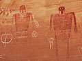
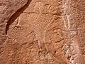
Without a doubt, my favorite rock art site along the Lower Butler Wash Road is the amazing Procession Panel, a 15-ft long petroglyph panel though to represent a ceremonial gathering or migration story.
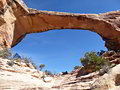
Owl Creek Canyon to Nevill's Arch ![]()
Distance: 9.6 miles (Round Trip)
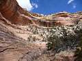
This strenuous hike travels down stunningly beautiful Owl Creek Canyon to Nevill’s Arch, an imposing span located atop a high fin.
Distance: 2.8 - 4.4 miles (Round Trip)
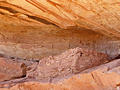
This short hike travels down scenic Road Canyon to an amazing archaeology site with seven kivas.
Distance: 11.5 - 15.8 miles (Round Trip)
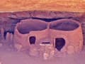
This strenuous hike leads to two fascinating ruins, Perfect Kiva and Jailhouse Ruin, in scenic Bullet Canyon. Past the ruins the trail continues down canyon to the confluence with Grand Gulch.
Distance: 0.8 - 1.4 miles (Round Trip)
The Wolfman Panel is fascinating both for its precise artwork as well as its interesting figures. The easy access and short hiking distance make this site a popular spot for rock art enthusiasts passing through the Bluff and Mexican Hat area.
Distance: 10.4 miles (Round Trip)
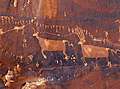
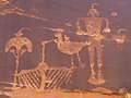
Two life-sized red and white pictographs, depicting a man and a woman, are the central focus of this fascinating rock art panel, located on a ledge high above Grand Gulch.
Kane Gulch to Junction and Turkey Pen Ruins ![]()
Distance: 7.0 - 9.7 miles (Round Trip)
Grand Gulch is often likened to an open air museum of Ancestral Puebloan ruins and rock art. This trail offers a great introduction to the canyon, visiting Junction Ruin and Turkey Pen Ruin and passing a nice viewpoint for Stimper Arch.
Collins to Bannister House Ruin ![]()
Distance: 9.0 miles (Round Trip)
This easy trail descends to scenic Grand Gulch and then travels up canyon to visit impressive Bannister House Ruins. Along the way the trail passes an old cowboy camp, an abandoned rincon, a small granary and small pictograph panels.
Natural Bridges National Monument Loop Trail ![]()
Distance: 8.6 miles (Loop)
This great loop hike in Natural Bridges National Monument visits three majestic natural bridges, crosses a high desert landscape and wanders along two scenic canyons with rock art panels and ancestral Puebloan ruins
Distance: 0.8 - 1.4 miles (Round Trip)
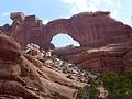
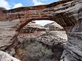
This adventurous hike in Natural Bridges features spectacular views of the Sipapu Bridge and White Canyon. Metal ladders, stairs and railings facilitate the steep descent to the base of the stunning formation. The hike is can be shortened for an easier day.
Distance: 1.4 miles (Round Trip)
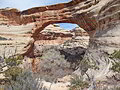
Descend to the floor of Armstrong Canyon for great views of the Kachina Bridge, a massive sandstone structure at the junction of White and Armstrong Canyons. Rock art and nearby ruins add interest to the hike.
Distance: 0.1 - 0.6 miles (Round Trip)
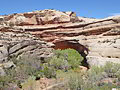
The Owachomo Bridge is the easiest to visit and the most elegant of the three spans in Natural Bridges National Monument. A half mile (RT) trail descends to and then crosses under this photogenic bridge, offering views of this natural wonder from a variety of angles.
Distance: 2.1 miles (Round Trip)
Explore a cave with the remains of a kiva and perennial spring along with a nearby alcove containing ruins and rock art on this easy hike up a short canyon off the Lower Butler Wash Road.
Distance: 1.6 miles (Round Trip)
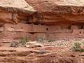
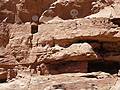
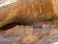
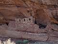
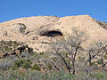
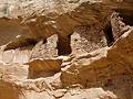
This short, easy trail leads to an impressive ruin situated in a deep, east facing alcove beneath a pour-off. The site, located in a side canyon off the Lower Butler Wash Road, includes an interesting structure with rounded walls along with rock art, pottery shards and grinding stones.
Distance: 3.6 - 8.0 miles (Round Trip)
A moderately-easy hike up a pleasant, shallow canyon with Ancestral Puebloan ruins and a few rock art sites.
Distance: 2.0 - 9.2 miles (Round Trip)
This easy hike offers an excellent opportunity to discover well preserved ruins tucked into alcoves and along the walls of side canyons in the scenic South Fork of Mule Canyon.
First Fork of Slickhorn Canyon ![]()
Distance: 4.9 - 9.0 miles (Round Trip)
Hikers making the very steep descent into the rugged, scenic First Fork of Slickhorn Canyon are rewarded with the opportunity to visit Perfect Kiva, one of the few kivas on Cedar Mesa that hikers are permitted to enter.
Distance: 3.0 - 5.4 miles (Round Trip)
This short, moderately-easy hike leads to a stunning rock art panel along the north side of the San Juan River.
Distance: 3.0 - 12.2 miles (Round Trip)
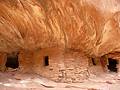
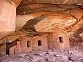
This hike can either be done as a short, moderately-easy walk to see Fallen Roof ruins or a long, more difficult trip that also visits Seven Kivas.
Distance: 1.9 miles (Round Trip)
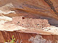
Four archaeology sites, some rock art and an impressive large and deep alcove lure hikers up a short, narrow canyon off the Lower Butler Wash Road.
Distance: 1.8 miles (Round Trip)
Two alcoves, stacked one atop of the other, harbor interesting ruins and rock art in a canyon off the Lower Butler Wash Road.
Distance: 1.3 miles (Round Trip)
Ruins, rock art and two sweat lodges are the highlights of this short hike in a brushy canyon to the west of the Lower Butler Wash Road.
Distance: 0.6 miles (Round Trip)
A short jaunt leads to the Horse Collar Overlook offering birds-eye-views of Horse Collar Ruin, a well-preserved ancestral Puebloan site, along with panoramic views of White Canyon and Deer Flat Mesa.
West Fork of Upper Butler Wash ![]()
Distance: 3.2 miles (Round Trip)
This short, moderately easy off-the-beaten-path hike travels up the West Fork of upper Butler Wash, visiting four archaeology sites along the way.
Slickhorn Canyon – Third Fork to Trail Fork ![]()
Distance: 10.5 miles (Loop)
This strenuous hike visits the scenic Third and Trail Forks of Slickhorn Canyon
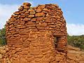
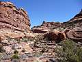
Cave Canyon Towers (aka Mule Canyon Towers) ![]()
Distance: 1.4 miles (Round Trip)
A short, easy hike to the ruins of seven towers located along the rim at the head of Cave Canyon. From the rim enjoy views of additional ruins tucked into alcoves and under ledges along the cliffs on the east/northeast canyon wall.
Distance: 1.3 miles (Round Trip)
On a day when a short hike makes sense, here is one to consider. The easy trail visits a few small ruins in Lower Mule Canyon, a scenic spot with off the Comb Wash road.
View Hikes by Area:
Southeast UtahArchesCanyonlandsMoabGrand GulchBears Ears NMNatural Bridges NMBluff