Procession Panel 
Distance: 2.8 miles (round trip)
BLM, Monticello, Utah office, near Bluff in Southeast Utah
By: Diane Greer
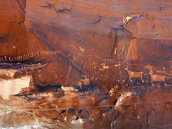
A slightly truncated view of Procession Panel
Without a doubt, my favorite rock art site along the Lower Butler Wash Road is the amazing Procession Panel, a 15-ft long petroglyph panel though to represent a ceremonial gathering or migration story.
See Trail Detail/Full Description
- Distance: 2.8 miles (round trip) to Procession Panel
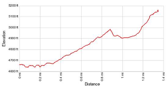
- Elevation: 4,630-ft. at Trailhead
5,140-ft. at Procession Panel - Elevation Gain: 510-ft. to Procession Panel
- Difficulty: moderate
- More Hikes in:
Bluff / Bears Ears NM / Southeast Utah
Why Hike Procession Panel
If you love rock art you will definitely want to visit Procession Panel, located along a southwest facing cliff, high atop Comb Ridge. The impressive petroglyph panel, thought to represent a ceremonial gathering or migration story, depicts 179 human-like forms coming from three different directions and converging on a central circle. Other figures in the panel include mountain sheep, deer and/or elk and snakes. A few smaller panels are located along the cliff just below the main panel.
The short trail to the site follows an ascending traverse up a slickrock bench and then climbs a rocky slope. A short section of the hike descends a moderately steep slickrock friction pitch.
The trail is best hiked in the spring and fall when temperatures are cooler. Be sure to carry plenty of water and get an early start. The hike will take longer than you think since you will spend a significant amount of time investigating the panel.
Elevation Profile
Trail Resources
Trail Detail/Full Description / Trail Photo Gallery / Trail Map
Basecamp(s) Information:
Bluff / Bears Ears NM
Region Information:
Southeast Utah
Other Hiking Regions in:
Utah