Details: Procession Panel 
Distance: 2.8 miles (round trip)
BLM, Monticello, Utah office, near Bluff in Southeast Utah
Hike Facts
- Distance: 2.8 miles (round trip)
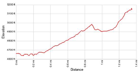
- Elevation: 4,630-ft. - 5,140-ft.
- Elevation Gain: 510-ft.
- Difficulty: moderate
- Trail Highlights: See Trail Intro
- Basecamp(s): Bluff / Blanding
- Region: Southeast Utah
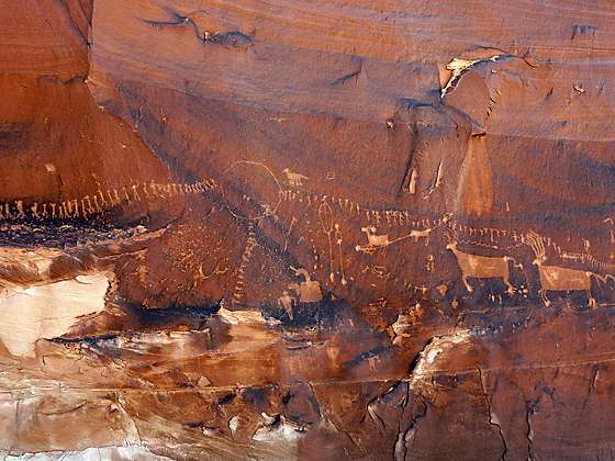
Without a doubt, my favorite rock art site along the Lower Butler Wash Road is the amazing Procession Panel, a 15-ft long petroglyph panel though to represent a ceremonial gathering or migration story.
To Procession Panel
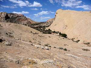
Comb Ridge is a stunning sandstone ridge of steeply tilted rock layers called a Monocline, a step-like fold in the rock strata. The ridge runs north-south for approximately 80 miles from Utah’s Abajo Mountain to Kayenta, Arizona. The jagged appearance of the ridge is similar to a rooster’s comb, hence the logic behind its name.
The Lower Butler Wash Road, which parallels the base of the ridge to the east, offers access to the ridge and its drainages which are renowned for the numerous prehistoric sites, including ruins and rock art. No matter how many time I visit the ridge I always allocate time to hike to Procession Panel, the most amazing petroglyph panel in the area.
The biggest challenge when exploring the sites along Butler Wash is finding the correct trailhead. There are no signs marking turnoffs to the various drainages. The best bet is to religiously keep track of your mileage as you progress up or down the road. (See the driving directions below for more information.)
On the southwest side of the parking area for Procession Panel, find a trail heading west/southwest. In a short distance the trail drops down a steep, sandy slope and crosses Butler Wash, a tangled mess of Cottonwoods, tamarisk and willows. On the west side of the wash a boot beaten trail climbs a bench and continues heading west, soon crossing another shallow wash.
Beyond the second wash the trail ascends on easy to moderately-easy grades across slopes sprinkled with juniper and sage, crossing sections of slickrock marked with rock cairns.
As you climb look straight ahead at the top of Comb Ridge. Notice there is a break in the ridge. Procession Panel is located along the west/southwest facing side of the ridge to the right of the break. There is a red sandstone ridge to the left of the break and a large rock outcropping just to the south of the red sandstone. Keep track of these features as you climb. The trail will descend into the canyon running between the break in the ridge.
At 0.5 miles the dirt trail gives way to slickrock slopes. Widely spaced rock cairns now identifying the route. Be careful to locate the next set of cairns before proceeding forward. As the route heads west, it works its way over to the south rim of an east-west trending canyon, reaching the rim at about 0.7 miles. Views to the north open to the Abajo Mountains.
The route now follows an ascending traverse on moderate grades along the canyon’s south rim for two-tenths of a mile and then drops down a steep slickrock slope to the canyon floor. Make note of the spot where you hit the canyon floor so that you do not miss the climb out the drainage on the return trip.
Follow the boot beaten path that heads west up the canyon. A little over a mile from the trailhead the path begins to curve to the right (northwest) on easy grades, ascending along the base of the ridge on the right side of the break. Along the way the BLM has placed a few brown mylar stakes marking the route.
At 1.2 miles the trail begins a very steep climb up the rocky slopes along the base of the ridge. The ridge’s sheer sandstone cliffs, adorned with desert varnish, tower overhead. As you climb, keep an eye out for small petroglyphs pecked into the cliff face, protected by overhangs.
Remember to treat all the rock art you discover with respect so that it may be enjoyed by future generations. Rock art is extremely fragile and easily damaged. Never touch rock panels as the oil on your fingers can speed the erosion of the rock art. Do not vandalize the panels by taking latex mold prints or rubbings from rock art or adding modern additions.
Reach Procession Panel (5,155-ft.) at 1.4 miles. The stunning panel, measuring about 15-ft. in length, depicts 179 anthropomorphs (human-like forms) coming from three different directions and converging on a central circle. Most of the anthropomorphs are not well defined but a few carry staffs and two wear bird head-dresses. Some of the figures are facing forward with their arms raised overhead and a group of five figures in a row seem to be carrying torches while others appear to have loads on their backs. Below the horizontal lines of figures are mountain sheep, deer and/or elk and snakes, along with other forms. One of the large deer or elk on the right side of the panel has a spear protruding from its belly.
The panel is thought to be from the Basketmaker III period. Some archaeologists believe the panel’s location, high atop a cliff, indicates a ceremonial theme for the gathering. Others talk of a pilgrimage or migration story.
It is easy to spend an hour or more at the site. The panel is fascinating. The more you look, the more you will see. As an added bonus the view to the west from the top of the cliff are amazing.
When you are done admiring the panel, retrace your steps to the trailhead.
Elevation Profile
Driving Directions
The surface of Utah County Road 262, the Butler Wash Road, is packed dirt with sections of slickrock. The road can be rutted, sandy and rough in place. Under good conditions the road is passable with a 2WD vehicle if driven carefully. High clearance or 4WD is better.
From Bluff: Drive southwest on US-191 S for 4.2 miles. Where US-191 turns south continue straight ahead on US 162 for 0.9 miles and turn right on County Road 262 / Lower Butler Wash Road. The road is located between mile posts 41 and 40 and is across from the Bluff Airport Road (County Road 269A). Almost immediately reach a gate across the road, secured by a chain. Make sure you close the gate after passing through. Drive 6.6 miles north to a spur road on the left. Turn left onto the spur and drive a short distance to a parking area.
From Mexican Hat: Drive east on US-163 for 19.6 miles and turn left on County Road 262 / Lower Butler Wash Road. The road is located between mile posts 41 and 40 and is across from the Bluff Airport Road (County Road 269A). Almost immediately reach a gate across the road, secured by a chain. Make sure you close the gate after passing through. Drive 6.6 miles north to a spur road on the left. Turn left onto the spur and drive a short distance to a parking area.
Trail Resources
Trail Intro / Trail Photo Gallery / Trail Map
Basecamp(s) Information:
Bluff / Blanding
Region Information:
Southeast Utah
Other Hiking Regions in:
Utah