Best Hikes in Southeast Utah
Location: The eastern quadrant of the state to the south of I70 encompassing Arches, Canyonlands, Cedar Mesa (including Grand Gulch) and the Comb Ridge area.
By: Diane Greer
Featured Hikes
Distance: 3.2 - 5.6 miles (Round Trip)
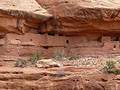
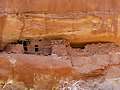
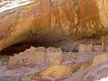
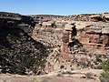
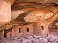
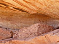
Moon House, one of the best archaeology sites on Cedar Mesa, consists of three separate structures with 49 rooms. Well preserved pictorgraphs grace the walls of an interior courtyard and some of the rooms.
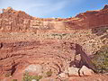
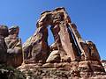
Distance: 5.4 - 10.9 miles (Loop)
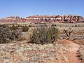
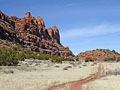
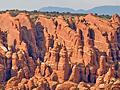
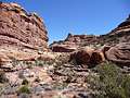
A long, entertaining circuit through a stunning landscape of sandstone spires, pinnacles, knobs, fins and monoliths surrounding a scenic expanse of desert grassland in the Needles District of Canyonlands National Park.
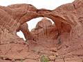
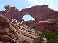
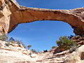
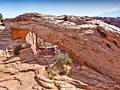
Distance: 3.1 miles (Round Trip)
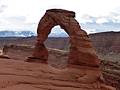
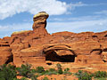
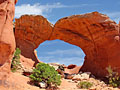
A short hike to a stunning, iconic arch perched on the edge of a huge sandstone bowl and framed by the scenic La Sal Mountains.
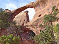
Distance: 1.8 - 7.7 miles (Loop)
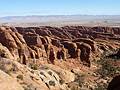
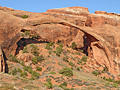
Seven amazing arches set amid a landscape of weird and wonderful sandstone fins, spires and knobs are the rewards for hiking the Devils Garden Trail, my favorite trail in Arches National Park.
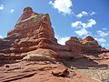
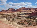
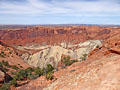
Lost Canyon/Big Spring Canyon Loop ![]()
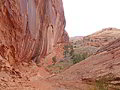
Distance: 8.7 - 10.5 miles (Loop)
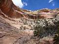
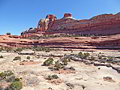
Spectacular canyon scenery awaits hikers on this varied loop hike traversing sandy washes, climbing slickrock benches and crossing steep sandstone ridges as it travels through three scenic canyons.
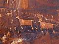
The Great Gallery in Horseshoe Canyon ![]()
Distance: 7.2 miles (Round Trip)
A nice hike to the Great Gallery, a phenomenal Barrier Canyon style rock art panel in a remote, detached unit of Canyonlands National Park.
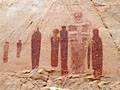
Distance: 2.8 miles (Round Trip)
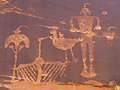
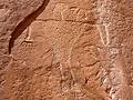
Without a doubt, my favorite rock art site along the Lower Butler Wash Road is the amazing Procession Panel, a 15-ft long petroglyph panel though to represent a ceremonial gathering or migration story.
Distance: 5.0 - 12.2 miles (Round Trip)
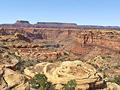
This trail offers options for all levels of hikers as it travels through diverse landscapes with terrific view of the maze of canyons and red rock formation beneath the Island in Sky mesa. Far reaching vistas stretch east to the La Sal Mountains and south to the Abajo Mountains.
Distance: 0.5 - 2.0 miles (Loop)
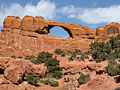
A photographer’s delight, this trail visits North Window, South Window, Turret Arch, and Double Arch, features great views of the areas distinctive rock formations and includes distant vistas of the La Sal Mountains.
Distance: 4.2 - 5.8 miles (Round Trip)
The trail to Double O Arch is one of the quintessential hikes in Arches National Park, featuring five notable arches along with views of an amazing concentration of sandstone fins, whimsical spires and sculpted knobs.
Distance: 10.4 miles (Round Trip)
A great hike to a high bench near the head of Elephant Canyon offering spectacular views of Druid Arch, a massive, uniquely-shaped angular arch. Along the way the trail travels through scenic Elephant Canyon, beneath sandstone walls sculpted into amazing shapes.
Mill Creek Canyon (North Fork) ![]()
Distance: 1.6 - 5.0 miles (Round Trip)
Towering sandstone walls, a perennial stream, waterfalls, swimming holes and rock art are the highlights of this interesting trail exploring scenic Mill Creek Canyon in southeast of Moab.
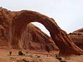
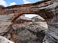
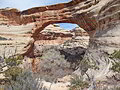
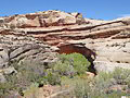
Owl Creek Canyon to Nevill's Arch ![]()
Distance: 9.6 miles (Round Trip)
This strenuous hike travels down stunningly beautiful Owl Creek Canyon to Nevill’s Arch, an imposing span located atop a high fin.
Distance: 2.5 miles (Round Trip)
A short, relatively easy trail leads to stunning Corona Arch and its fascinating neighbor, Bowtie Arch, situated in a huge sandstone amphitheatre high above the northwest wall of Bootlegger Canyon.
Distance: 0.9 - 1.8 miles (Round Trip)
Stroll beneath soaring sandstone formations topped with sculpted pinnacles, towers and spires on this short, highly scenic hike through a dramatic canyon in Arches National Park.
Distance: 2.8 - 4.4 miles (Round Trip)
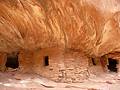
This short hike travels down scenic Road Canyon to an amazing archaeology site with seven kivas.
Distance: 11.5 - 15.8 miles (Round Trip)
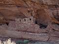
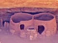
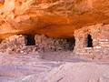
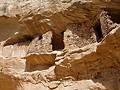
This strenuous hike leads to two fascinating ruins, Perfect Kiva and Jailhouse Ruin, in scenic Bullet Canyon. Past the ruins the trail continues down canyon to the confluence with Grand Gulch.
Distance: 4.9 - 7.3 miles (Round Trip)
Fine views of the Behind the Rocks and the La Sal Mountains along with the option to see great rock art panels make this a recommended hike.
Distance: 8.3 miles (Loop)
This interesting and challenging trail travels around Upheaval Dome, a fascinating geological feature in the Island in the Sky district of Canyonlands National Park. The trail, recommended for experienced hikers only, descends rugged Upheaval Canyon and climbs out via a beautiful and difficult trail up the Syncline Valley.
Distance: 0.8 - 1.4 miles (Round Trip)
The Wolfman Panel is fascinating both for its precise artwork as well as its interesting figures. The easy access and short hiking distance make this site a popular spot for rock art enthusiasts passing through the Bluff and Mexican Hat area.

Distance: 10.4 miles (Round Trip)
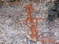
Two life-sized red and white pictographs, depicting a man and a woman, are the central focus of this fascinating rock art panel, located on a ledge high above Grand Gulch.
Kane Gulch to Junction and Turkey Pen Ruins ![]()
Distance: 7.0 - 9.7 miles (Round Trip)
Grand Gulch is often likened to an open air museum of Ancestral Puebloan ruins and rock art. This trail offers a great introduction to the canyon, visiting Junction Ruin and Turkey Pen Ruin and passing a nice viewpoint for Stimper Arch.
Collins to Bannister House Ruin ![]()
Distance: 9.0 miles (Round Trip)
This easy trail descends to scenic Grand Gulch and then travels up canyon to visit impressive Bannister House Ruins. Along the way the trail passes an old cowboy camp, an abandoned rincon, a small granary and small pictograph panels.
Natural Bridges National Monument Loop Trail ![]()
Distance: 8.6 miles (Loop)
This great loop hike in Natural Bridges National Monument visits three majestic natural bridges, crosses a high desert landscape and wanders along two scenic canyons with rock art panels and ancestral Puebloan ruins
Distance: 0.8 - 1.4 miles (Round Trip)
This adventurous hike in Natural Bridges features spectacular views of the Sipapu Bridge and White Canyon. Metal ladders, stairs and railings facilitate the steep descent to the base of the stunning formation. The hike is can be shortened for an easier day.
Distance: 1.4 miles (Round Trip)
Descend to the floor of Armstrong Canyon for great views of the Kachina Bridge, a massive sandstone structure at the junction of White and Armstrong Canyons. Rock art and nearby ruins add interest to the hike.
Distance: 0.1 - 0.6 miles (Round Trip)
The Owachomo Bridge is the easiest to visit and the most elegant of the three spans in Natural Bridges National Monument. A half mile (RT) trail descends to and then crosses under this photogenic bridge, offering views of this natural wonder from a variety of angles.
Distance: 2.1 miles (Round Trip)
Explore a cave with the remains of a kiva and perennial spring along with a nearby alcove containing ruins and rock art on this easy hike up a short canyon off the Lower Butler Wash Road.
Distance: 1.6 miles (Round Trip)
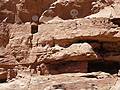
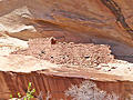
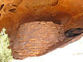
This short, easy trail leads to an impressive ruin situated in a deep, east facing alcove beneath a pour-off. The site, located in a side canyon off the Lower Butler Wash Road, includes an interesting structure with rounded walls along with rock art, pottery shards and grinding stones.
Distance: 2.3 miles (Loop)
The Fiery Furnace hike travels through a fascinating labyrinth of fins, narrow canyons and weird rock formations. Agility and proper footwear are required to complete the demanding route only accessible on a Ranger-led hike or with a day-use permit.
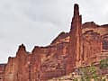
Distance: 1.8 - 4.4 miles (Round Trip)
The Fisher Towers trail winds through stunning red rock towers shaped by erosional forces into impressive formations. Seldom does a short hike pack in such amazing views. Enroute visit the 900-ft. tall Titan, the U.S.’s largest free standing sandstone spire, soaring above the trail.
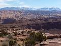
Distance: 8.0 - 10.4 miles (Round Trip)
The terrific hike features non-stop views of the ever changing panorama of weird and wonderful sandstone formations, canyons, buttes and mesas stretching north to the La Sal Mountains. The last segment features an extended high elevation walk along slickrock bench and over ridges.
Distance: 1.8 - 2.3 miles (Round Trip)
The broad, easy trail to Landscape Arch is popular and deservedly so. The spectacularly slender arch seeming defies gravity with its thinnest section, only 6-ft. thick, supporting a span of entrada sandstone that is 290-ft. long.
Distance: 9.6 miles (Round Trip)
The Murphy Trail is one of my favorite hikes in the Island in the Sky District of Canyonlands National Park with far reaching views of the vast landscape to the south and west of the Island in the Sky plateau.
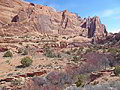
Squaw Canyon to Big Spring Canyon Loop ![]()
Distance: 7.4 miles (Round Trip)
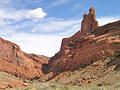
This quintessential trail in the Needles District of Canyonlands National Park visits two scenic canyons linked by a high slickrock saddle featuring stunning views of a sandstone landscape of sculpted rock spires, monoliths and fins.
Distance: 3.0 - 7.6 miles (Round Trip)
This beautiful hike traveling up the South Fork of Mill Creek features soaring sandstone walls, rock art and a perennial stream with lovely cascades and large pools. The South Fork offers more solitude than its sibling the North Fork and is a more interesting hike.
Distance: 8.0 - 10.4 miles (Round Trip)
The Amasa Back trail offers a challenging, view packed hike to a ridge overlooking the Colorado River and the red rock country beyond.
Distance: 3.6 - 8.0 miles (Round Trip)
A moderately-easy hike up a pleasant, shallow canyon with Ancestral Puebloan ruins and a few rock art sites.
Distance: 2.7 - 5.7 miles (Round Trip)
An off-the-beaten-path hike in the Klondike Bluffs area of Arches National Park leads through a secluded valley ringed by a wonderland of deep-red rock formations before reaching Tower Arch, an immense span with lovely views to the west.
Distance: 2.0 - 9.2 miles (Round Trip)
This easy hike offers an excellent opportunity to discover well preserved ruins tucked into alcoves and along the walls of side canyons in the scenic South Fork of Mule Canyon.
Distance: 4.0 miles (Round Trip)
Wonderful views of a stunning canyon, solitude and an impressive jeep-shaped arch more than compensate for the difficulty in following a trail, which is poorly defined in places.
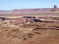
Dead Horse State Park Loop Trails ![]()
Distance: 2.0 - 6.6 miles (Loop)
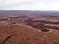
Amazing vistas of the sculpted canyons, pinnacles and buttes defining the landscape along the Colorado River and nearby Canyonlands National Park are the highlights of this easy 6.0 mile loop hike traveling around the southern end of Dead Horse State Park.
Distance: 2.0 miles (Round Trip)
Spectacular panoramic views of the red rock canyon between the Colorado and Green Rivers, the Needles and Maze Districts of Canyonlands National Park and beyond are the scenic rewards for this easy hike to the southern tip of the Island in the Sky mesa in Canyonlands National Park.
First Fork of Slickhorn Canyon ![]()
Distance: 4.9 - 9.0 miles (Round Trip)
Hikers making the very steep descent into the rugged, scenic First Fork of Slickhorn Canyon are rewarded with the opportunity to visit Perfect Kiva, one of the few kivas on Cedar Mesa that hikers are permitted to enter.
Distance: 3.0 - 5.4 miles (Round Trip)
This short, moderately-easy hike leads to a stunning rock art panel along the north side of the San Juan River.
Distance: 3.0 - 12.2 miles (Round Trip)
This hike can either be done as a short, moderately-easy walk to see Fallen Roof ruins or a long, more difficult trip that also visits Seven Kivas.
Distance: 1.9 miles (Round Trip)
Four archaeology sites, some rock art and an impressive large and deep alcove lure hikers up a short, narrow canyon off the Lower Butler Wash Road.
Distance: 0.6 miles (Loop)
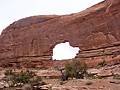
A short, easy hike leads to a photogenic arch perched on a cliff edge with great views of the La Sal Mountains, Buck Canyon and Washer Woman Arch. This is a popular trail, especially with sunrise photographers.
Distance: 1.8 - 3.4 miles (Round Trip)
Looking for a short hike that is long on solitude and features scenic cliffs, rock art and views of the Colorado River? Then hike to Moki Mesa, situated atop a bench between the Colorado River and Poison Spider Mesa.
Distance: 1.8 miles (Round Trip)
Two alcoves, stacked one atop of the other, harbor interesting ruins and rock art in a canyon off the Lower Butler Wash Road.
Distance: 0.6 miles (Loop)
This short, entertaining hike visits an old cowboy camp and the Cave Spring alcove, harboring a spring and pictographs. Beyond the alcove the trail climbs atop a slickrock formation with fine views of nearby rock formation. Distant views stretch to the Abajo and La Sal Mountains.
Distance: 1.3 miles (Round Trip)
Ruins, rock art and two sweat lodges are the highlights of this short hike in a brushy canyon to the west of the Lower Butler Wash Road.
Distance: 0.6 miles (Round Trip)
A short jaunt leads to the Horse Collar Overlook offering birds-eye-views of Horse Collar Ruin, a well-preserved ancestral Puebloan site, along with panoramic views of White Canyon and Deer Flat Mesa.
Distance: 0.6 - 1.7 miles (Round Trip)
A short hike leads to a fascinating viewpoint overlooking a geologic anomaly in canyon country where rock layers are dramatically deformed into a dome surrounded by a giant anticline, which looks like a crater measuring nearly 3-miles across.
Distance: 0.9 - 1.7 miles (Round Trip)
A steep climb up a slickrock dome leads to ancestral Puebloan granaries and outstanding views of Taylor Canyon.
West Fork of Upper Butler Wash ![]()
Distance: 3.2 miles (Round Trip)
This short, moderately easy off-the-beaten-path hike travels up the West Fork of upper Butler Wash, visiting four archaeology sites along the way.
Slickhorn Canyon – Third Fork to Trail Fork ![]()
Distance: 10.5 miles (Loop)
This strenuous hike visits the scenic Third and Trail Forks of Slickhorn Canyon
Distance: 2.6 miles (Loop)
This interesting trail loops around the slickrock-topped mesa between Big Spring and Little Spring Canyons, offering good views of two canyons and surrounding landmarks. The trail is a great option for families or anyone who has never hiked on slickrock.
Sand Dune, Broken and Tapestry Arches Loop ![]()
Distance: 1.6 - 2.7 miles (Loop)
This moderately-easy family hike visits three interesting arches; Sand Dune Arch, Broken Arch and Tapestry Arch, and travels through scenic desert landscape on uncrowded trails, a rarity in Arches National Park.
Distance: 0.3 miles (Loop)
This short, easy trail leads to an Ancestral Puebloan granary tucked into a ledge above a dry wash. A self-guided trail brochure describes the plants along the trail and how they were used by the Ancestral Puebloans. This is a good introductory desert hike for children of all ages.
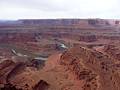
Distance: 9.8 miles (Round Trip)
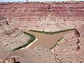
This trail crosses dry, open country and ends at a cliff overlooking the confluence of the Green and Colorado Rivers, 1,000-ft. below.
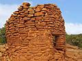
Cave Canyon Towers (aka Mule Canyon Towers) ![]()
Distance: 1.4 miles (Round Trip)
A short, easy hike to the ruins of seven towers located along the rim at the head of Cave Canyon. From the rim enjoy views of additional ruins tucked into alcoves and under ledges along the cliffs on the east/northeast canyon wall.
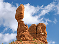
Distance: 0.3 miles (Round Trip)
The Balanced Rock trail circles a photogenic 128-ft. tall rock formation, offering a variety of perspectives of the formation and the surrounding landscape in Arches National Park.
Distance: 1.3 miles (Round Trip)
On a day when a short hike makes sense, here is one to consider. The easy trail visits a few small ruins in Lower Mule Canyon, a scenic spot with off the Comb Wash road.
Distance: 0.3 miles (Round Trip)
A short hike to a secluded arch nestled among sandstone fins, south of the Devil’s Garden section of Arches National Park.
Distance: 0.4 miles (Round Trip)
Distinctive Skyline Arch graces the top of a large fin and is visible from many viewpoints around Arches National Park. A short, easy trail leading to the base of the arch provides up-close views of this impressive span.
View Hikes by Area:
ArchesCanyonlandsMoabGrand GulchBears Ears NMNatural Bridges NMBluff
The Region, the Hikes & the Base Camps
The high desert plateaus of southeast Utah are carved into a maze of intricate canyons, mesas, buttes, fins, arches and spires. Two national parks, two national forest a huge recreation area and millions of acres of BLM land protect this amazing landscape. Hiking informatioin is available for Arches National Park, Canyonlands National Park, Moab, Grand Gulch, Bears Ears, Blanding and Bluff.
This guide highlights the best hikes in the region, the trails that travel through scenic canyons, visit magnificent arches and lead to spectacular panoramic viewpoints. Numerous hikes offer the opportunity to discover Ancestral Puebloan cliff ruins and rock art in a natural setting.
Base Camp Information:
ArchesCanyonlandsMoabGrand GulchBears Ears NMNatural Bridges NMBluff