Best Hikes in Canyonlands National Park
Location: Southeast Utah
Composed of three districts, the Island in the Sky, the Needles and the Maze, located, respectively, to the north, southeast and west of the confluence of the Green River and the Colorado River in southeast Utah.
Hiking Trails in the Island in the Sky District of Canyonlands National Park
Distance: 5.0 - 12.2 miles (Round Trip)
This trail offers options for all levels of hikers as it travels through diverse landscapes with terrific view of the maze of canyons and red rock formation beneath the Island in Sky mesa. Far reaching vistas stretch east to the La Sal Mountains and south to the Abajo Mountains.
Distance: 8.3 miles (Loop)
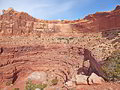
This interesting and challenging trail travels around Upheaval Dome, a fascinating geological feature in the Island in the Sky district of Canyonlands National Park. The trail, recommended for experienced hikers only, descends rugged Upheaval Canyon and climbs out via a beautiful and difficult trail up the Syncline Valley.
Distance: 9.6 miles (Round Trip)
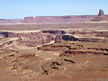
The Murphy Trail is one of my favorite hikes in the Island in the Sky District of Canyonlands National Park with far reaching views of the vast landscape to the south and west of the Island in the Sky plateau.
Distance: 2.0 miles (Round Trip)
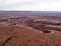
Spectacular panoramic views of the red rock canyon between the Colorado and Green Rivers, the Needles and Maze Districts of Canyonlands National Park and beyond are the scenic rewards for this easy hike to the southern tip of the Island in the Sky mesa in Canyonlands National Park.
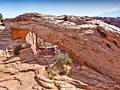
Distance: 0.6 miles (Loop)
A short, easy hike leads to a photogenic arch perched on a cliff edge with great views of the La Sal Mountains, Buck Canyon and Washer Woman Arch. This is a popular trail, especially with sunrise photographers.
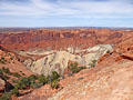
Distance: 0.6 - 1.7 miles (Round Trip)
A short hike leads to a fascinating viewpoint overlooking a geologic anomaly in canyon country where rock layers are dramatically deformed into a dome surrounded by a giant anticline, which looks like a crater measuring nearly 3-miles across.
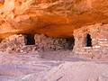
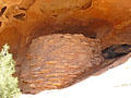
Distance: 0.9 - 1.7 miles (Round Trip)
A steep climb up a slickrock dome leads to ancestral Puebloan granaries and outstanding views of Taylor Canyon.
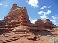
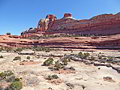
Hiking Trails in the Needles District of Canyonlands National Park
Distance: 5.4 - 10.9 miles (Loop)
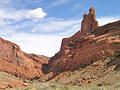
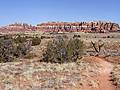
A long, entertaining circuit through a stunning landscape of sandstone spires, pinnacles, knobs, fins and monoliths surrounding a scenic expanse of desert grassland in the Needles District of Canyonlands National Park.
Lost Canyon/Big Spring Canyon Loop ![]()
Distance: 8.7 - 10.5 miles (Loop)
Spectacular canyon scenery awaits hikers on this varied loop hike traversing sandy washes, climbing slickrock benches and crossing steep sandstone ridges as it travels through three scenic canyons.
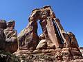
Distance: 10.4 miles (Round Trip)
A great hike to a high bench near the head of Elephant Canyon offering spectacular views of Druid Arch, a massive, uniquely-shaped angular arch. Along the way the trail travels through scenic Elephant Canyon, beneath sandstone walls sculpted into amazing shapes.
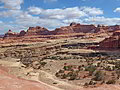
Distance: 8.0 - 10.4 miles (Round Trip)
The terrific hike features non-stop views of the ever changing panorama of weird and wonderful sandstone formations, canyons, buttes and mesas stretching north to the La Sal Mountains. The last segment features an extended high elevation walk along slickrock bench and over ridges.
Squaw Canyon to Big Spring Canyon Loop ![]()
Distance: 7.4 miles (Round Trip)
This quintessential trail in the Needles District of Canyonlands National Park visits two scenic canyons linked by a high slickrock saddle featuring stunning views of a sandstone landscape of sculpted rock spires, monoliths and fins.
Distance: 0.6 miles (Loop)
This short, entertaining hike visits an old cowboy camp and the Cave Spring alcove, harboring a spring and pictographs. Beyond the alcove the trail climbs atop a slickrock formation with fine views of nearby rock formation. Distant views stretch to the Abajo and La Sal Mountains.
Distance: 2.6 miles (Loop)
This interesting trail loops around the slickrock-topped mesa between Big Spring and Little Spring Canyons, offering good views of two canyons and surrounding landmarks. The trail is a great option for families or anyone who has never hiked on slickrock.
Distance: 0.3 miles (Loop)
This short, easy trail leads to an Ancestral Puebloan granary tucked into a ledge above a dry wash. A self-guided trail brochure describes the plants along the trail and how they were used by the Ancestral Puebloans. This is a good introductory desert hike for children of all ages.
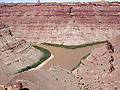
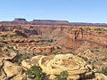
Distance: 9.8 miles (Round Trip)
This trail crosses dry, open country and ends at a cliff overlooking the confluence of the Green and Colorado Rivers, 1,000-ft. below.
Hiking Trails in the Horseshoe Canyon District of Canyonlands National Park
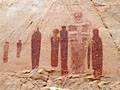
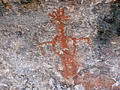
The Great Gallery in Horseshoe Canyon ![]()
Distance: 7.2 miles (Round Trip)
A nice hike to the Great Gallery, a phenomenal Barrier Canyon style rock art panel in a remote, detached unit of Canyonlands National Park.
View Hikes by Area:
Southeast UtahArchesCanyonlandsMoabGrand GulchBears Ears NMMonticelloMexican HatBluff