Roadside Ruin 
Distance: 0.3 miles
Needles District, Canyonlands National Park, near Canyonlands in Southeast Utah
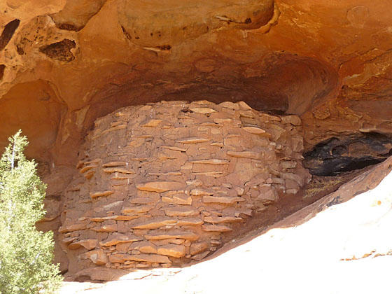
Granary
This short, easy trail leads to an Ancestral Puebloan granary tucked into a ledge above a dry wash. A self-guided trail brochure describes the plants along the trail and how they were used by the Ancestral Puebloans. This is a good introductory desert hike for children of all ages.
- Distance: 0.3 miles (Loop)
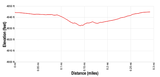
- Elevation: 4,945-ft. at Trailhead
Maximum elevation - 4,932-ft. - Elevation Gain: -13-ft.
- Difficulty: easy
- Basecamp: Canyonlands / Monticello
- Region: Southeast Utah
Trail Description - Roadside Ruin
This is a great trail for families with small children, anyone new to desert hiking or hikers who would like a close-up view of a granary. The trailhead is located at the north end of the Roadside Ruin pullout, the first pullout after passing the Needles District Visitor Center on Highway 211. (See driving directions below.)
A wood box at the trailhead holds the self-guided trail brochures explaining the cultural history of the area and the plants along the trail. At the “Y” intersection, just after the information box, turn right to walk the loop in a counter-clockwise direction. (The loop hike is best walked in this direction to follow along with the trail brochure.)
The trail now heads east, descending on gentle grades across sagebrush flats scattered with junipers. After 0.1 miles the trail dips into a dry wash, turns north and soon reaches a junction. Turn right at the junction and follow the trail a short distance to a fenced area where you can see the granary tucked into a small alcove above the wash. This particular structure is in very good shape.
Granaries were typically used for storing harvested grains or seeds. Many granaries include doors, often sealed with a large flat rock. Interestingly this granary does not seem to have a door. Some speculate that it was filled from the top. How the granary was then sealed to protect its contents from mice and other rodents is a mystery.
To return to the parking area, retrace your steps to the junction and take the trail to the right that climbs out of the wash and then heads west. Along the way the trail crosses a few slickrock outcroppings. Cairns (small piles of rocks) mark the trail across the slickrock.
The path returns to the parking at just under 0.3 miles. Unless you want to keep the brochure, please recycle the trail guide by returning it to the box.
Elevation Profile
Driving Directions
From Moab: Drive south on U.S. Highway 191 for roughly 40 miles to Utah Highway 211 (signed for Canyonlands National Park, Needles District) and turn right (west). Follow Utah Highway 211 west for 34.8 miles to a pullout along the left (east) side of the road signed for Roadside Ruin. This is the first pullout after passing the Visitor Center.
From Monticello: Drive north on U.S. Highway 191 for roughly 14.3 miles to Utah Highway 211 (signed for Canyonlands National Park, Needles District) and turn left (west). Follow Utah Highway 211 west for 34.8 miles to a pullout along the left (east) side of the road signed for Roadside Ruin. This is the first pullout after passing the Visitor Center.
From Blanding, UT: Drive north on U.S. Highway 191 for roughly 34.8 miles to Utah Highway 211 (signed for Canyonlands National Park, Needles District) and turn left (west). Follow Utah Highway 211 west for 34.8 miles to a pullout along the left (east) side of the road signed for Roadside Ruin. This is the first pullout after passing the Visitor Center.
Trail Resources
- Trail Photo Gallery
- Trail Maps
- Basecamp(s) Information: Canyonlands / Monticello
- Region Information: Southeast Utah
- Other Hiking Regions in: Utah