Details: Road Canyon 
Distance: 3.0 - 12.2 miles (round trip)
BLM, Monticello, Utah office, near Blanding in Southeast Utah
Hike Facts
- Distance: 3.0 - 12.2 miles (round trip)
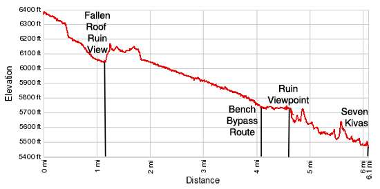
- Elevation: 6,390-ft. - 5,445-ft.
- Elevation Gain: -945-ft.
- Difficulty: moderate-strenuous
- Trail Highlights: See Trail Intro
- Basecamp(s): Blanding
- Region: Southeast Utah
This hike can either be done as a short, moderately-easy walk to see Fallen Roof ruins or a long, more difficult trip that also visits Seven Kivas.
To Fallen Roof Ruin
Distance from Trailhead: 3.0 miles (round trip)
Ending/Highest Elevation: 6,040-ft.
Elevation Gain: -350-ft.
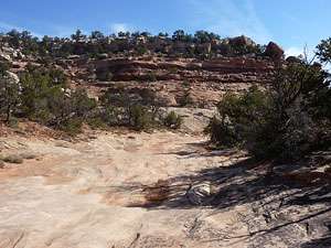
The trailhead for Upper Road Canyon is located down Cigarette Springs off UT-261, 9.7 miles south of the Kane Gulch Ranger Station. (See the driving directions below for more information.) At the northwest end of the parking area a good trail, marked by a BLM sign, heads northeast through pinyon pines and junipers to the rim of Road Canyon. The path then travels along the rim for a short distance before starting its descent into the canyon at 0.4 miles.
Follow the trail as it switchbacks down into the canyon on moderate grades, reaching the floor after losing 100-ft. At the bottom make sure you note where the trail begins its climb out of the canyon so you do not miss the exit on the return trip.
The trail now weaves its way along the canyon floor on easy grades, traveling along the wash with occasional detours to avoid boulders, brush and small pour-offs. At 0.9 miles the trail passes a side canyon to the left (north) and curves to the east/southeast on a boot beaten path along the grassy wash.
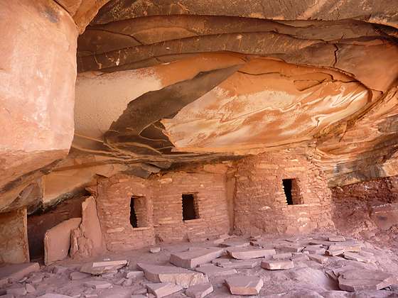
After walking a little over a mile there are two landmarks that indicate you are close to the ruin known as Fallen Roof. The first is a sandstone pillar midway up the canyon’s north wall. The second is a small slickrock pour-off in the wash, which is easy to walk down. A short distance after spotting the pillar and negotiating the pour-off watch for a rock cairn placed on the slickrock ledge to the left (north) of the trail. The cairn marks the start of the route that climbs over 100-ft. up the canyon’s north wall to Fallen Roof ruin. The ruin, located in a small alcove, can be seen from the trail.
Hikers comfortable with climbing slickrock friction pitches and ledges will have no difficulty ascending the cairned route to the alcove. Photogenic Fallen Roof ruin, named for the large slabs that have fallen from the alcove’s ceiling, contains four small structures. Three of the structures are in excellent condition. Ancient corn cobs litter the floors of the ruins. Please leave these artifacts in place.
Please treat these fragile ruins with respect so that it may be enjoyed by future generations. Do not sit, climb or step on the walls of any structures or attempt to enter the structures. Leave any pot shards, corn cobs or other relic where you found them. Remember that rock art is extremely fragile and easily damaged. Never touch rock panels as the oil on your fingers can speed the erosion of the rock art. Do not vandalize the panels by taking latex mold prints or rubbings from rock art or adding modern additions. See the BLM Guide for Visiting Archaeology Sites for more information on how to protect these priceless and irreplaceable sites.
On the bench just below the alcove is a use trail that contours along ledges, heading southeast and then northeast for 0.25 miles to more ruins. The ruins tucked beneath small overhangs along the bench include granaries and the partial remains of walls. The last two structures are excellent examples of well preserved wattle and daub construction, a technique where vertical stakes (wattles) are woven with horizontal branches and then covered in mud.
After visiting the last structures on the bench, reverse your route and descend back to the canyon floor. Note the route along the bench includes travel along a few narrow ledges with some exposure and is not recommended for small children or anyone with a fear of heights.
Fallen Roof ruin and the other structures are viewable from the canyon floor. Bring binoculars or a camera with a zoom lens to improve your view.
Most people turn around and return to the trailhead after seeing Fallen Roof. Total hiking distance is 3.0 miles round trip, including the hike along the bench to see the other ruins.
To Ruin Viewpoint
Distance from Trailhead: 9.2 miles (round trip)
Ending/Highest Elevation: 5,630-ft.
Elevation Gain: -760-ft.
For a longer walk continue hiking down Road Canyon. Beyond Fallen Roof ruins the trail continues its descending traverse on easy grades alternating between the wash and its adjacent benches.
Note: All mileage beyond this point assumes a visit to Fallen Roof ruins. If you instead view the ruins from the canyon floor, subtract 0.7 miles from the mileage numbers for the remainder of the hike.
At 2.3 miles look for a small ruin built under an alcove along the canyon’s north wall. A few small granaries are located along the wall at 2.5 miles.
Reach a small pour-off at 3.7 miles, easily bypassed on the left. A second pour-off at 3.9 miles is also easily bypassed on the left. Arrive at a third larger pour-off at 4.1 miles. Detour to the right (east) of the pour-off and find a cairned trail that climbs to and travels along a bench high above the canyon floor. Continue along the bench for 0.5 miles to a point directly across from a set of ruins along the north wall. Back track a short distance and find a very steep trail that climbs down ledges and descends slickrock friction pitches to the canyon floor.
If you are at all uncomfortable with the route, do not attempt the descent. Instead find a nice spot to take a break and view the ruins across the canyon before retracing your steps to the trailhead. Total round-trip distance to the viewpoint is 9.2 miles.
To Seven Kivas
Distance from Trailhead: 12.2 miles (round trip)
Ending/Highest Elevation: 5,445-ft.
Elevation Gain: -945-ft.
Upon reaching the canyon floor follow the boot beaten path down canyon for 0.6 miles to the unmarked junction with a trail ascending a side canyon to the right (west), 5.1 miles from the trailhead. This is the shortcut trail to Seven Kivas. The shortcut trail descends from the rim of Road Canyon to the junction and then continues down canyon to Seven Kivas. For more information on the short cut trail see: Road Canyon to Seven Kivas.
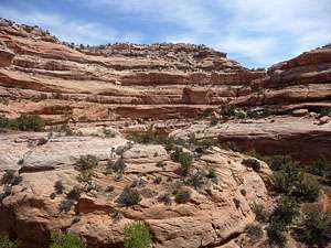
From the junction the sinuous trail continues down canyon, echoing the canyon’s twist and turns as it weaves its way between the wash and the adjacent benches. Red and white sandstone walls, sculpted by wind and water into ledges, bays, alcoves and overhangs, rise 400-ft above the canyon floor. Junipers, pinyon pines, grasses and sagebrush grow along the canyon’s floor and the ledges protruding from the sandstone walls.
As the canyon curves to the north around the next bend, at 5.3 miles, look for a small granary tucked in a narrow alcove along the canyon’s southeastern wall. Soon the canyon makes a “U”-turn to the southeast and travels down the slickrock clad wash, which may contain running water in the spring or after a rainfall.
At 5.5 miles the canyon rounds another bend and heads northeast. Ahead you will soon see a hoodoo rising along the canyon’s southeastern wall. As you come abreast of the hoodoo a side canyon opens to the north at 5.8 miles. Pass the side canyon and continue following the wash as it curves to the southeast and then back to the north.
At 6.0 miles the canyon widens and the trail swings to the east. Here the floor of the canyon is covered with a huge expanse of slickrock. A short distance along the north side of the canyon is an alcove on a low bench, which looks to be covered in piles of stone. This is Seven Kivas.
To protect the site the BLM has erected chains to keep people from climbing the fragile slopes directly in front of the site. Instead, look for the boot beaten path on the right (east) side of the site that climbs up a rocky slope to the top of the bench.
This fascinating site is very fragile. Please be very careful during your visit. Do not sit, climb or step on the walls of any structures, walk on the roofs of the kivas or attempt to enter the structures. Leave any pot shards, corn cobs or other relic where you found them. Treat the site with reverence and respect.
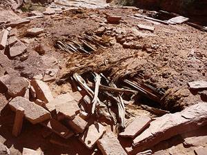
The site, as the name suggests, consists of seven kivas thought to be 700 to 800 years old. Two of the kiva’s still include partially intact roofs. As you study these structures note that the roofs are constructed in layers. Larger wood beams support a network of small beams or sticks. Wattling or matting, typically composed of bark or other vegetative matter, is placed atop the smaller beams and then covered with adobe.
If you look inside one of the kivas you will see some of the original plaster work. The vertical support beam in the middle of the kiva is not original but installed by the BLM to prevent the roof from collapsing.
The other kivas are in poor shape. Mortar is missing on many of the exposed walls. The BLM has placed chains around the site to prevent people walking across on the most sensitive areas of the site. Please respect these closures.
In addition to the kivas there appear to be a few other structures in this alcove. There are also a few structures in the alcove to the east of the site.
After investigating this interesting ruin retrace your steps back to the trailhead. Hikers with a second vehicle can shorten the hike by entering Road Canyon from the upper trailhead and exiting via the shortcut. Total round trip distance for the hike using two vehicles is 7.5 miles. See the information on hiking Road Canyon to Seven Kivas for a description of the shortcut trail out of Road Canyon and driving directions to the shortcut trailhead.
Elevation Profile
Driving Directions
From Blanding: Drive south on US 191 S for 4 miles and turn right (west) on UT-95 N. Follow UT-95 for 28.4 miles and turn left (south) on UT-261 S. Head south on UT 261 for 13.6 miles and turn left (east) on the County Road 239 / Cigarette Springs, located between mile posts 19 and 20. (The turn is 9.7 miles south of the Kane Gulch Ranger Station.) There is a BLM sign for the Cigarette Springs Road setback from the highway. Follow the dirt road (County Road 239) for 3.4 miles to an unmarked spur road on the left. Travel about 100 yards up the spur road to its end where you will find several parking bays and some campsites. The Cigarette Springs Road and the unmarked spur road can be sandy and rough in places and become impassable when wet.
From Mexican Hat: Head north on US-163 for 3.9 miles and turn left (north) on UT-261 N. Follow UT-261 north for 19.1 miles and turn right (east) on the County Road 239 / Cigarette Springs, located between mile posts 20 and 19. There is a BLM sign for the Cigarette Springs Road setback from the highway. Follow the dirt road (County Road 239) for 3.4 miles to an unmarked spur road on the left. Travel about 100 yards up the spur road to its end where you will find several parking bays and some campsites. The Cigarette Springs Road and the unmarked spur road can be sandy and rough in places and become impassable when wet. Note: a short section of UT-261 climbs steep gravel switchbacks up the Moki Dugway
Trail Resources
Trail Intro / Trail Photo Gallery / Trail Map
Basecamp(s) Information:
Blanding
Region Information:
Southeast Utah
Other Hiking Regions in:
Utah