Backpack: Washakie Pass, Lizard Head, Cirque of the Towers Loop
Segment 1: Big Sandy to Marms Lake
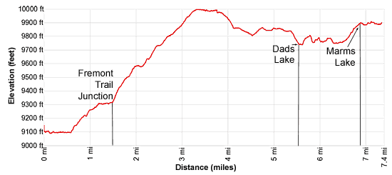
Distance: 7.4 miles (one way)
Bridger Wilderness, Bridger-Teton National Forest, near Big Sandy in Wyoming's Wind River Range
By: Diane Greer
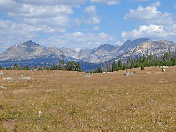
East Fork Cirque
- Distance: 7.4 miles
- Elevation: 0.0 miles to Big Sandy Trailhead (9,085-ft.)
0.6 miles to Junction with Sedgewick Meadow/Big Sandy Trails (9,120-ft )
1.3 miles to Junction Diamond Lake (9,320-ft.)
1.5 miles to Junction Fremont Trail (9,355-ft.)
5.5 miles to Dad’s Lake (9,741-ft.)
6.8 miles to Marms Lake (9,878-ft.)
7.4 miles to Junction Pyramid Lake Trail (9,925-ft.) - Difficulty: moderate
- Basecamp: Big Sandy
- Region: Wyoming's Wind River Range
Big Sandy to Marms Lake Description
From the Big Sandy trailhead kiosk at the northeast end of the parking area, a wide path heads north on easy grades through trees and meadows along the west side of the Big Sandy River. Reach the junction with the Sedgewick Meadow trail branching right (east) at 0.6 miles. The Sedgewick Meadows trail is the shortest and most popular route to Big Sandy Lake. We continue straight ahead towards Dad’s Lake, ascending on moderately-easy grades along the Continental Divide Trail (CDT).
The grade abates as the trail passes Meeks Lakes, hidden in the trees to the west of the trail, at 1.2 miles. Reach a "Y" intersection at 1.3 miles. The trail to the right is a longer, albeit more scenic, route to Big Sandy Lake via V and Diamond Lakes. We bear left (west) on the CDT trail toward Dads and Marms Lakes.
Soon the trail crosses the inlet stream for Meek Lake and then traverses a large meadow with views of Laturio Mountain (11,305-ft.) rising to the northeast. At 1.5 miles reach the junction with the Fremont Trail at the western edge of the meadow. Turn right (north) on the Fremont, heading toward Dads, Cross and North Fork Lakes. The trail to the left leads to the Big Sandy Lodge and the stock corrals near the trailhead.
The trail now ascends on moderate to easy grades through pine forest. Small meadows and openings in the trees offer nice views of Laturio Mountain to the east/northeast.
At 3.3 miles the grade abates as the trail begins a half mile traverse through a glorious meadow. Here terrific views stretch north to the massive cirque at the head of the East Fork Valley dominated by Mount Geikie (12,378-ft.), Mount Bonneville (12,585-ft.), Tower Peak (12,330-ft.), Mount Hooker (12,504-ft.) and Pyramid Peak (12,030-ft.). Midway through the meadow pass a sign verifying that you are on the CDT trail heading for Dad’s Lake. Some large flat rocks at the north end of the meadow offer great spots to rest and enjoy the view.
At 3.8 miles the trail descends through scattered trees and the meadows of Fish Creek Park to Fish Creek. From the meadows views extend east to Fish Lake and the peaks rising to the east. Cross Fish Creek at 4.5 miles and then ascend on moderate grades through meadows on the north side of the park to Mirror Lake at 4.75 miles.
The trail now travels along the western shore of Mirror Lake. Beyond the lake the path descends on easy grades through marshy meadows, skirting the right (east) side of a draw. In route the path crosses a minor creek and passes the junction with the Donald Lake trail heading right (east) at 5.25 miles.
Beyond the junction the trail starts descending to Dads Lake. The high peaks of the East Fork cirque form the backdrop for this pretty, irregular shaped lake studded with small rocky islands. As you descend, pass a use trail branching left (west) that leads to nice campsites along the south and west sides of the lake.
Reach the south end of Dads Lake (9,741-ft.) at 5.5 miles. The undulating trail climbs over a series of rocky knolls to the east side of the lake. During much of the traverse the lake is out of views. After descending from the first knoll the trail crosses Donald Lake’s outlet stream at 5.8 miles. By early to mid-July you can keep your feet reasonable dry by rock-hopping across the stream. Wading may be required during periods of high water.
At the north end of Dads Lake travels through a marshy meadow, crossing the lake’s inlet stream along the way. Past the meadow the path climbs on moderate grades up a narrow, rocky draw along the left (west) side of a stream. At the top of the draw the trail drops slightly to reach the south end of Marms Lake (9,878-ft.) at 6.8 miles. Good campsites around the lake are in short supply. The best spots are above the south and north ends of the lake. Unless you are exhausted, my advice is to continue beyond Marms to find a good campsite.
Follow the trail along Marm’s western shore with good views of the peaks rising along the divide to the east. To the northeast is the ridge lining the south side of the Washakie Creek Valley.
At the north end of the lake reach a trail junction at 7.4 miles. Here the Pyramid Lake Trail, signed for Shadow Lake, branches right (northeast) and leads to Shadow Lake (along with Skull, Mae’s and Pyramid Lakes). The trail branching left (north), the continuation of the Fremont trail, heads to Cross Lake and beyond.
Return to Introduction: Washakie Pass, Lizard Head, Cirque of the Towers Loop
Go To Segment 2: Marms Lake to Washakie Pass Trail Junction
Elevation Profile
Backpack Segments
- Introduction: Washakie Pass, Lizard Head, Cirque of the Towers Loop
- Segment 1: Big Sandy Trailhead to Marms Lake
- Segment 2: Marms Lake to Washakie Pass Trail Junction
- --- Side Trip: Shadow Lake, Texas Lake and Texas Pass
- Segment 3: Over Washakie Pass to Valentine Lake
- Segment 4: Valentine Lake to Cirque of the Towers via Lizard Head Plateau
- Segment 5: Cirque of the Towers to Big Sandy Trailhead via Jackass Pass
Driving Directions to Big Sandy Trailhead
The Big Sandy Trailhead is located in the southern Wind River Range next to the Big Sandy River.
Directions from Pinedale: From the intersection of Pine Street (US 191) and North Tyler Ave (the Pinedale Tourism office is located on the northeast corner) in Pinedale, WY, drive south on Highway 191 for 11.7 miles and then turn left (east) on WY-353. After 15.5 miles you will notice signs referring to the road as the Big Sandy-Elkhorn Road and after 18 miles the paved road will change to a good packed dirt/gravel surface.
Shortly after the pavement ends go straight through a junction, and drive south crossing the Big Sandy River (Buckskin Crossing). Follow the road for a total of 27.3 miles. Shortly after crossing the Big Sandy River you will reach a junction with the Lander Cutoff Road (the next junction). Turn left on the Lander Cutoff Road. There is a wood sign at the intersection pointing toward the Big Sandy trailhead.
Drive 7.0 miles on the Lander Cutoff Road and then turn left on the Big Sandy Opening Road. Here you will see a sign for the Big Sandy Campground and trailhead. The road now deteriorates and narrows. Blind corners and lush foliage along the road make it hard to see ahead. Drive carefully, following the rocky, rutted road for 9.8 miles to a "Y" intersection. Bear right at the intersection to continue along the Big Sandy Opening Road (Forest Service Road 850). (The road branching to the left leads to the Big Sandy Lodge and Mud Lake.) Follow the road for 0.8 miles to the trailhead parking area, equipped with an outhouse.
Allow an hour and a half to reach the trailhead from Pinedale. The parking area is too small for the number of backpackers visiting the area during the height of the summer. If the parking area is full, find a safe place to park off the access road.
I recommend a high clearance vehicle to reach the trailhead. Passenger cars can make it OK if driven carefully. Check at the Pinedale ranger station before starting your trip to learn about current road and trail conditions. The Ranger Station is located to the east of the Ridleys Grocery Store on US 191 (Pine Street in Pinedale). The entrance to the ranger station is on the Fremont Lake Road. (You can also reach the parking area for the ranger station by driving east through the Ridley’s parking lot.)
This trailhead is remote, so be sure to have a full tank of gas. The dirt road become slippery when wet. The campground at the parking area is tiny, with only 4 sites. I would not plan on camping at the trailhead before starting your backpack.
Trail Resources
- Backpack Intro
- Segment Photo Gallery
- Segment Map
- Trailhead(s) Information: Big Sandy
- Region Information: Wyoming's Wind River Range
- Other Hiking Regions in: Wyoming