Backpack: Washakie Pass, Lizard Head, Cirque of the Towers Loop
Segment 3: Washakie Pass Trail to Valentine Lake
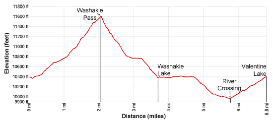
Distance: 6.8 miles (one way)
Bridge and Popo Agie Wildernesses, Bridger-Teton and Shoshone National Forests, near Big Sandy in Wyoming's Wind River Range
By: Diane Greer
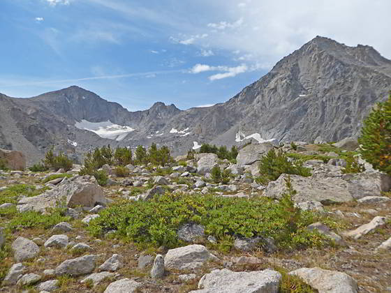
Big Chief Mountain, Washakie Glacier and Washakie Peak
- Distance: 6.8 miles
- Elevation: 0.0 miles to Junction Washakie Pass Trail (10,410-ft.)
2.0 miles to Washakie Pass (11,611-ft.)
3.7 miles to Washakie Lake (10,363-ft.)
5.7 miles to Junction Bear Ears Trail (9,980-ft.)
6.8 miles to Valentine Lake (10,399-ft.) - Difficulty: strenuous
- Basecamp: Big Sandy
- Region: Wyoming's Wind River Range
Washakie Pass Trail to Valentine Lake Description
Most parties spend a night a Skull Lake before crossing Washakie Pass. If you visit Skull Lake before crossing the pass, add 0.4 miles to the trail mileage in the description below.
From Skull Lake climb the trail heading south to the junction with the Washakie Pass trail and turn left (east) on the trail to the pass. (If coming from Washakie Creek, turn right (east) at the junction on the Washakie Pass trail.)
Ascend on easy to moderate grade through a pretty meadows scattered with trees and rock outcroppings. Great views extend northwest to Mt. Geikie (12,378-ft.), Ambush Peak (12,187-ft.), Raid Peak (12,532-ft.), Mt. Bonneville (12,585-ft.) and Tower Peak (12,330-ft.).
At 0.7 miles the serrated summits along the backside of the Cirque of the Towers form the backdrop for a small tarn. To the northwest the peaks forming the cirque at the head of the East Fork valley rise above a low ridge. A short distance beyond the tarn the trail curves to the left (northeast).
As you ascend the trees thin and the trail now weaves its way through meadows studded with rock outcroppings. Ahead Mount Washakie (12,524-ft.) dominates the view. To the northwest enjoy ever improving views of Mt. Geikie, Ambush peak and Raid Peak. Turn around for views of Twin Buttes (11,108-ft.) towering above a vast alpine meadows to the west.
At 1.1 miles the grade steepens as we leave the last of the trees behind. The trail now ascends steeply through rocky alpine meadows. Ahead Washakie Pass, the saddle on the ridge between Mount Washakie and Bernard Peak (12,393-ft.), is now in view. The final stiff climb to the pass travels through rocky alpine tundra.
Reach Washakie Pass (11,611-ft.) at 2.0 miles. As your crest the pass, views open east to the sheer cliffs and high peaks towering above Macon and Washakie Lakes nestled in the alpine basin below the pass. The summit of Lizard Head Peak (12,842-ft.) appears above the ridge to the southeast while Cathedral peak rises above the Lizard Head Plateau to the east.
The pass literally appears to have a split personality with the gray granite slopes of Mount Washakie looming above the pass to the south while the dark brown volcanic rock of Bernard Peak rises to the north.
After taking in the views carefully descend switchbacks down the very steep talus slopes on the east side of the pass. The going is difficult if slick snow and ice cover the trail. After losing about 200-ft. the trail gets a bit easier.
Soon the path leaves the talus behind and continues its steep descent through rocky meadows, occasionally crossing small streams carrying snowmelt from the steep slopes above the trail. Be sure to follow the cairned route as you descend from the pass. It is easy to miss a jog in the trail if you are not paying attention.
At 2.5 miles, about 480-ft. below the pass, the trail briefly hits the top of the ridge above Pass Lake (10,627-ft.). To the south views open to the Washakie Glacier tucked in a bowl beneath Big Chief Mountain (12,335-ft.). Mount Washakie towers above the Pass Lake basin.
Soon the grade abates as the trail reaches the western end of Macon Lake (10,771-ft.) at 2.9 miles. Here a rocky trail travels along the lake’s southern shore, winding its way around large erratic boulders. At the mid-point of the lake the path crosses the outlet stream on rocks.
From the lakeshore enjoy great views of Big Chief Mountain, Washakie Glacier, Mount Washakie, Washakie Pass and Bernard Peak. The lake is a favorite of fishermen but is too exposed and rocky for good camping. My advice is to continue to Washakie Lake to camp.
At 3.2 miles the trail starts the steep descent through meadows and spruce-pine forest to the bench holding Washakie Lake (10,363-ft.), arriving at the lake’s western shore at 3.7 miles after losing a little over 370-ft. Buffalo Head and the sheer cliffs extending south from the formation form the backdrop for this beautiful lake.
Here the trail turns north, traveling on easy grades through meadows and scattered trees along the west side of the lake. At 4.0 miles the trail crosses and inlet stream and then curves to the right (east), traversing the north side of the lake. If you are looking to camp, the best sites are located above the lake’s north and west shores.
At 4.2 miles the trail curves to the left (northeast) and reaches the end of the bench at 4.7 miles. Along this section of the hike Buffalo Head (11,717-ft.) is your constant companion, towering above the lake basin to the east.
The trail now descends from the bench on moderate grades. Openings in the trees offer views to the north of the unnamed peaks in the Wind River Indian Reservation. At 5.1 miles the trail crosses the outlet stream for Loch Leven Lake. Soon the grade eases and the trees give way to meadows as the path parallels the west side of the South Fork of the Little Wind River.
Reach a junction with the Bear Ears trail at 5.7 miles. Bear right (east) on the Bear Ears trail which drops down to and crosses the river and then heads toward Valentine Lake. The segment of the Bear Ears trail continuing straight ahead (downstream) leads to Graves Lake and is used as part of a loop hike that crosses Hailey Passes. LINK
The river ranges from shin to knee deep with a good current. Trekking poles or a stick are helpful to keep your balance when negotiating the slimy rocks along the river bed and during periods of high water.
On the east side of the creek the trail turns south and ascends through trees up a hot, dry hillside to Ranger Park at 6.0 miles. Here the trail turns left (east), crosses the north end of the park and reenters the trees. The trail now climbs switchbacks on moderate grades through trees to the outlet stream for Valentine Lake (10,399-ft.) at 6.8 miles.
Valentine Lake is set amid a backdrop of the sheer granite cliffs of the Lizard Head Plateau. Valentine Lake, or Little Valentine Lake further up the trail, are good places to spend the night before tackling the crossing of the Lizard Head Plateau.
Camping is not permitted around the Valentine Lake’s outlet stream. The best campsites are found along the lake’s western shore. To explore this area backtrack about 600-ft. from the outlet stream and look for a use trail heading left (south). (If you are coming up the trail from the South Fork the use trail is to your right.) The trail wanders between some large boulders and then fades as it crosses a meadow. Beyond the meadow you will find vestiges of trails that climb to campsites nestled atop the knolls and above small coves along the lake’s western shore.
Exploring around Valentine Lake
To the south of Valentine Lake are the seldom visited South Fork Lakes. To reach the lakes, find the use trail that travels along the low ridge to the west of Valentine Lake. This trail heads south into the area. Along the way you will pass Lake 10544 with very nice campsites. It is about 1.5 miles to the South Fork Lakes, nestled in a stunning basin surrounds by granite peaks and cliffs. The lakes are reported to have good fishing for cutthroat trout. Make sure you have a map to help you find the lakes and explore the area.
Return to Segment 2: Marms Lake to Washakie Pass Trail Junction
Go To Segment 4: Valentine Lake to Cirque of the Towers via Lizard Head Plateau
Elevation Profile
Backpack Segments
- Introduction: Washakie Pass, Lizard Head, Cirque of the Towers Loop
- Segment 1: Big Sandy Trailhead to Marms Lake
- Segment 2: Marms Lake to Washakie Pass Trail Junction
- --- Side Trip: Shadow Lake, Texas Lake and Texas Pass
- Segment 3: Over Washakie Pass to Valentine Lake
- Segment 4: Valentine Lake to Cirque of the Towers via Lizard Head Plateau
- Segment 5: Cirque of the Towers to Big Sandy Trailhead via Jackass Pass
Driving Directions to Big Sandy Trailhead
The Big Sandy Trailhead is located in the southern Wind River Range next to the Big Sandy River.
Directions from Pinedale: From the intersection of Pine Street (US 191) and North Tyler Ave (the Pinedale Tourism office is located on the northeast corner) in Pinedale, WY, drive south on Highway 191 for 11.7 miles and then turn left (east) on WY-353. After 15.5 miles you will notice signs referring to the road as the Big Sandy-Elkhorn Road and after 18 miles the paved road will change to a good packed dirt/gravel surface.
Shortly after the pavement ends go straight through a junction, and drive south crossing the Big Sandy River (Buckskin Crossing). Follow the road for a total of 27.3 miles. Shortly after crossing the Big Sandy River you will reach a junction with the Lander Cutoff Road (the next junction). Turn left on the Lander Cutoff Road. There is a wood sign at the intersection pointing toward the Big Sandy trailhead.
Drive 7.0 miles on the Lander Cutoff Road and then turn left on the Big Sandy Opening Road. Here you will see a sign for the Big Sandy Campground and trailhead. The road now deteriorates and narrows. Blind corners and lush foliage along the road make it hard to see ahead. Drive carefully, following the rocky, rutted road for 9.8 miles to a "Y" intersection. Bear right at the intersection to continue along the Big Sandy Opening Road (Forest Service Road 850). (The road branching to the left leads to the Big Sandy Lodge and Mud Lake.) Follow the road for 0.8 miles to the trailhead parking area, equipped with an outhouse.
Allow an hour and a half to reach the trailhead from Pinedale. The parking area is too small for the number of backpackers visiting the area during the height of the summer. If the parking area is full, find a safe place to park off the access road.
I recommend a high clearance vehicle to reach the trailhead. Passenger cars can make it OK if driven carefully. Check at the Pinedale ranger station before starting your trip to learn about current road and trail conditions. The Ranger Station is located to the east of the Ridleys Grocery Store on US 191 (Pine Street in Pinedale). The entrance to the ranger station is on the Fremont Lake Road. (You can also reach the parking area for the ranger station by driving east through the Ridley’s parking lot.)
This trailhead is remote, so be sure to have a full tank of gas. The dirt road become slippery when wet. The campground at the parking area is tiny, with only 4 sites. I would not plan on camping at the trailhead before starting your backpack.
Trail Resources
- Backpack Intro
- Segment Photo Gallery
- Segment Map
- Trailhead(s) Information: Big Sandy
- Region Information: Wyoming's Wind River Range
- Other Hiking Regions in: Wyoming