Details: Glacier Trail (day hike) 
Distance: 6.5 - 16.0 miles (round trip)
Fitzpatrick Wilderness Area, Shoshone National Forest, near Dubois in Wyoming's Wind River Range
Hike Facts
- Distance: 6.5 - 16.0 miles (round trip)
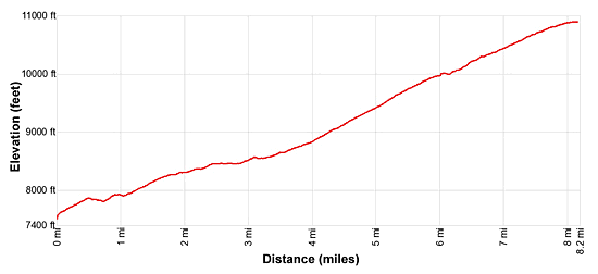
- Elevation: 7,597-ft. - 10,895-ft.
- Elevation Gain: 983-ft. - 3,390-ft.
- Difficulty: strenuous
- Trail Highlights: See Trail Intro
- Basecamp(s): Dubois
- Region: Wyoming's Wind River Range
This hike ascends East Torrey Creek to Bomber Basin and then climbs the slopes of Arrow Mountain to an overlook at 10,000-ft. and Pass 10,895-ft. Views encompass Torrey Peak, Middle Mountain, Whiskey Mountain, the Absaroka Range and, at the pass, Horse Ridge and Burro Flats.
To Upper Bomber Basin
Distance from Trailhead: 6.5 miles (round trip)
Ending/Highest Elevation: 8,580-ft.
Elevation Gain: 985-ft.
The trailhead for the Glacier Trail, shared by the Whiskey Mountain and Lake Louise trails, starts at the southwest end of the Trail Lake parking area. (See trailhead directions below.) The path heads west across dry, sage-covered flats and then climbs moderate to moderately-steep switchbacks up the south facing slopes of Whiskey Mountain. There is little to no shade along the open slopes scattered with sage and junipers, making this segment of the walk very hot during the height of the summer. An early start is strongly advised.
After 0.5 miles reach a junction where the Whiskey Mountain Trail continues straight ahead and the Glacier trail branches left (south). Turn left on the Glacier Trail. The path now descends on easy grades to a second junction at 0.7 miles, passing the boundary for the Fitzpatrick Wilderness along the way. At the junction turn left on the Glacier Trail which descends to a wood bridge over East Torrey Creek. The trail to the right leads to Lake Louise.
Beyond the bridge the path ascends south/southwest on moderate grades, traveling through granite knobs set amid small meadows and clusters of conifers along the east side of East Torrey Creek in Bomber Basin. Bomber Basin got its name in 1942 after a WWII fighter pilot crashed his plane in the basin on a training run and started a forest fire.
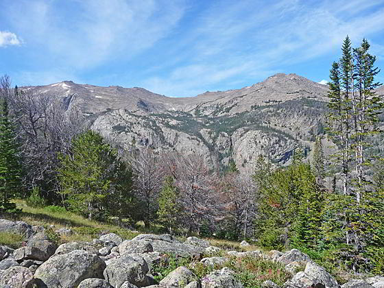
As you climb, enjoy nice views of Middle Mountain and Torrey Peak to the southwest. The colorful cliffs along the south facing slopes of Whiskey Mountain dominate the view to the northwest.
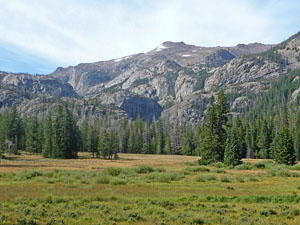
The grade eases as the trail passes a small marshy area and then enters the trees at 1.9 miles. Soon the valley constricts. The trail now travels near the creek as it continues its ascent. At 2.3 miles the path climbs two short switchbacks, reaching the meadows of lower Bomber Basin at 2.4 miles. The easy ascent through the lower meadows is accompanied by fine view of Torrey Peak and the rocky walls lining the west side of the basin. East Torrey Creek spills down the valley floor.
At 2.75 miles the path travels through a rocky area and soon enters the trees, ascending a bench to upper Bomber Basin. Here Torrey Peak towers above a beautiful expanse of marshy meadows sprinkled with willows. Domes and knobs define the basin’s walls.
Reach a junction at 3.25 miles where the Glacier Trail bears left and leaves the meadows. An unmarked use trail to Bomber Falls branches right. This trail continues up the meadows a short distance before crossing a stream and then climbing through trees to the base of Bomber Falls. Once the trail enters the trees it fades and is hard to follow. Unfortunately dense foliage makes it difficult to see the falls.
This junction is a good turn around point for hikers looking for a shorter day. Find a nice perch near the trail in the upper basin and enjoy the views before turning around and retracing your steps to the trailhead for a 6.5 miles round-trip hike.
Bomber Basin to the Overlook
Distance from Trailhead: 11.6 miles (round trip)
Ending/Highest Elevation: 10,200-ft.
Elevation Gain: 2,605-ft.
To continue the hike, turn left on the Glacier Trail that now ascends on moderate grades through trees, crossing a tributary stream along the way. At 3.8 miles the path curves to the southeast and starts climbing moderate-steep switchbacks through trees up the rocky west facing slopes beneath Arrow Mountain. Openings offer nice views of Whiskey Mountain’s south facing slopes to the northwest.
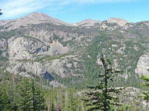
At 4.3 miles the trail leaves the trees and climbs switchbacks up talus slopes where views open west/southwest to Middle Mountain and Torrey Peak. Whiskey Mountain dominates the view to the northwest while the southern Absaroka Range fills the skyline to the north. At 4.7 miles the path reenters the trees where openings continue to offer fine views west to Middle Mountain and northwest to the summits of Whiskey Mountain.
The grade abates at 5.8 miles as the trail emerges onto a large meadow at 10,000-ft. This is a good turn around point for day hikers. To get the best views, climb a short distance west to the top of a meadow clad ridge (10,025-ft.) at 5.9 miles for expansive vistas of the surrounding area.
Peak 11695, a rugged pyramid-shaped summit rises to the south. Torrey Peak and Middle Mountain tower above the west side of the valley. Whiskey Mountain graces the skyline to the northwest while the southern Absaroka Range fills the horizon to the north. The meadow clad slopes to Arrow Mountain rise above the trail to the east.
The overlook is the recommend turnaround point for day hikers. After taking a break and enjoying the views turn around and return to the trailhead for a 11.6 mile round-trip hike.
Viewpoint to Pass 10895 (Arrow Pass)
Distance from Trailhead: 16.0 miles (round trip)
Ending/Highest Elevation: 10,895-ft.
Elevation Gain: 3,390-ft.
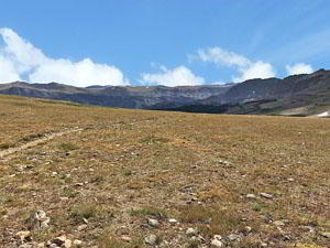
Strong day hikers can continue up the trail, which travels through meadows on easy grades and then crosses two creeks. Beyond the creek crossings the path ascends on moderate grades through meadows above the east side of a willow-lined stream, crossing two seasonal creeks along the way. After passing a rock outcropping on the left (east) and the site of the Williamson Corrals right (west), the path soon reaches the junction with the Old Glacier Trail, still used by outfitters, at 6.9 miles.
The combined trails now ascend on moderate to easy grades through alpine meadows sprinkled with willows, passing between Peak 11,695, to the west, and Peak 11, 696, to the east. Finally the path reaches Pass 10,895 at 8.0 miles. The pass, marked by a large cairn and a post, is sometimes referred to as Arrow Pass. Horse Ridge fills the skyline to the south while Burro Flat is seen below the pass to the southwest.
When you are done taking in the views, retrace your steps to the trailhead.
Elevation Profile
Driving Directions
From Dubois: From the corner of N 1st Street and US 26 in Dubois, drive 3.7 miles east on US 26 / US 287 and then turn right onto Whiskey Basin/Trail Lake Road. The turn is a short distance beyond the bridge crossing Jakeys Fork. Almost immediately turn left to stay on Trail Lake Road (aka Forest Service #411). (The turn to the right leads to the Fish Hatchery.) Follow the road for 9.1 miles to its end at the Trail Lake parking area. Here you will find the Glacier, Whisky Mountain, Lake Louise and Bomber Basin trailhead.
Note: Before reaching the end of the road there are left turns leading to a parking area for horse trailers and an overflow parking area.
Trail Resources
Trail Intro / Trail Photo Gallery / Trail Map
Basecamp(s) Information:
Dubois
Region Information:
Wyoming's Wind River Range
Other Hiking Regions in:
Wyoming