Details: Photographer's Point 
Distance: 9.4 miles (round trip)
Bridger Wilderness, Bridger-Teton National Forest, near Elkhart Park in Wyoming's Wind River Range
Hike Facts
- Distance: 9.4 miles (round trip)
- Elevation: 9,340-ft. - 10,350-ft.
- Elevation Gain: 1,010-ft.
- Difficulty: moderate
- Trail Highlights: See Trail Intro
- Basecamp(s): Elkhart Park
- Region: Wyoming's Wind River Range
Photographer’s Point, one of the most popular day hikes in the Wind River Range, leads to a breathtaking overlook where a sea of jagged summits along the western side of the Continental Divide fill the horizon.
Photographer's Point
The trail to Photographer’s Point follows the first 4.7 miles of the Pole Creek Trail (#119), which starts at the northeast end of the large parking lot at the Elkhart Park trailhead between the outhouse and trailhead kiosk. (See driving directions for the trailhead.) This is a heavily trafficked route used by backpackers and pack outfitters to reach Island Lake.
The trail immediately plunges into forest and briefly ascends north on easy grades. Soon the path curves to the right (southeast) and continues climbing through trees on easy to moderate grades along the southwest side of the Faler Creek Valley. Views occasionally open to willow-choked meadows along the valley floor. Twice I have seen Moose grazing among the willows. As you ascend the trail gets rockier and can be quite muddy after it rains.
At 1.7 miles the trail curves to the left (northeast) and ascends on moderate grades through spruce-pine forest. The grade eases as 2.1 miles and at 2.3 miles as the path enters the Bridger Wilderness. Beyond the wilderness boundary the trail resumes climbing and curves to the right (east) at 2.7 miles.
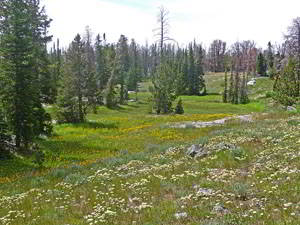
Soon the grade eases as the trail traverses the meadows of Miller Park, passing the junction with the Miller Lake trail at 3.3 miles. Here we get a preview of coming attractions with distant views of the high peaks in the northern portion of the Wind River Range.
At the edge of the second meadow the trail turns to the left (north/northeast) and briefly ascends on moderate to easy grades through trees and then a third meadow with views to the north of Mount Helen (13,620-ft.), Mount Sacagawea (13,569-ft.) and Fremont Peak (13,745-ft.).
The landscape changes as the trail exits the meadows. The path now climbs on moderate grades through forest and small meadows set amid rock outcropping and granite knobs. At 4.1 miles the path turns to the left (north), passing a few small ponds nestled amid boggy meadows.
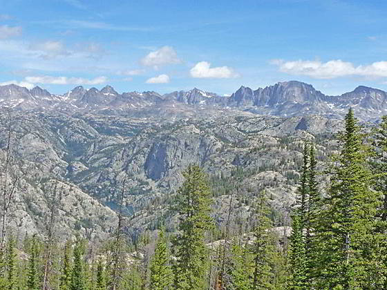
Reach Photographer’s Point at 4.7 miles. From the aptly named viewpoint a stunning panorama of high peaks fills the skyline to the north. Visible summits towering above the area between Island Lake and the upper Fremont Creek Valley include Bow Mountain (13,020-ft.), American Legion Peak (13,205-ft.), Mt. Woodrow Wilson (13,502-ft.), Mount Helen, Mount Sacagawea, Fremont Peak and Jackson Peak. Below the viewpoint is the deep canyon carved by Fremont Creek. Look carefully and you will see the south end of Gorge Lake on the canyon floor. In the mid-distance are a sea of granite knobs and low peaks.
The granite outcroppings at the viewpoint offer a nice perch to take in the views and eat lunch. When you are done enjoying the scene, retrace your steps to the trailhead.
Elevation Profile
Driving Directions
Directions from Pinedale: From the intersection of Pine Street (US 191) and North Tyler Ave (the Pinedale Tourism office is located on the northeast corner) in Pinedale, WY, drive east on Highway 191 (East Pine Street) for 0.3 miles and bear left onto Fremont Lake Road. Follow this road for 14.3 miles and turn right into the large parking area for the Elkhart Park/Pole Creek Trailhead. After the first 3.0 miles the road will turn into Skyline Drive/Forest Service Road 370740. The trailhead is located at the northeast end of the parking lot between the outhouse and the trailhead kiosk. It should take about 25 minutes to drive the trailhead. The last section of the road has some holes and uneven spots.
Trail Resources
Trail Intro / Trail Photo Gallery / Trail Map
Basecamp(s) Information:
Elkhart Park
Region Information:
Wyoming's Wind River Range
Other Hiking Regions in:
Wyoming