Baldwin Loop 
Distance: 2.3 - 3.1 miles
Coconino National Forest, near Sedona in Arizona's Red Rock Country
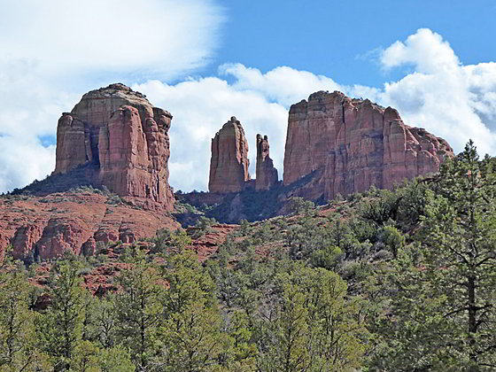
Escape the crowds on this trail that travels around an unnamed red rock butte with stunning views of the west side of Cathedral Rock. Extend the hike by taking side trips to visit beautiful Oak Creek.
- Distance: 2.3 - 3.1 miles (RT)
- Elevation: 4,015-ft. at Trailhead
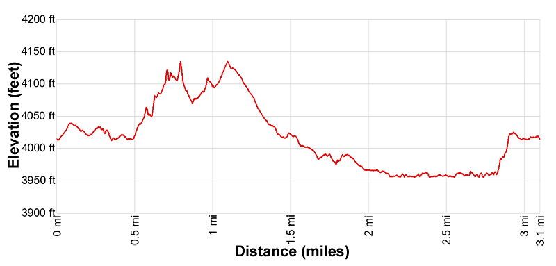
Maximum elevation - 4,135-ft. - Elevation Gain: 120-ft.
- Difficulty: moderate
- Basecamp: Sedona
- Region: Arizona's Red Rock Country
Trail Description - Baldwin Loop

This trail can be walked in either direction. I prefer clock-wise, leaving the best views and the side trips along Oak Creek for the end of the hike.
Note: Some hikers use this trail to access Cathedral Rock. If this is your primary purpose then follow the trail in the clock-wise direction. After hiking 0.5 miles reach a junction with the Templeton Trail. Continue straight ahead on the Templeton Trail, which intersect the Cathedral Rock trail at 1.3 miles.
From the north end of the Baldwin Trailhead parking area (see driving directions below), cross to the trailhead on the right (east) side of the Verde Valley Road. There is also an unmarked use trail across the road from the south end of the parking area. From the south end of the parking area cross the road and briefly ascend the use trail which quickly ends at the Baldwin Trail. For either option, turn right to walk the Baldwin Trail in a counter-clockwise direction.
The path now heads south, descending to cross a wash at 0.15 miles. After climbing out of the wash the undulating trail continues south paralleling electrical lines. Ahead (south/southwest) are views of House Mountain.
Reach a junction at 0.5 miles and turn left (southeast) to stay on the Baldwin Loop. The trail straight heads leads to the Turkey Creek Trailhead. The path briefly ascends through scrub pines and junipers with views of the unnamed butte rising to the northeast. The Baldwin trail loops around this formation. Capitol Butte and Bear Mountain are seen in the distance to the north/northwest.
At 0.75 miles the trail curves to the left (east) around the south end of the unnamed butte. The buttes rugged red rock slopes rise above the trail to the left. Ahead views open to Cathedral Rock.
After crossing the mouth of a shallow side canyon the path curves to the left (northeast) into the valley between Cathedral Rock and the unnamed butte. Here the path ascends on moderate grades along the east side of the unnamed butte, accompanied by superb views of Cathedral Rock.
Reach the highpoint of the loop trail at 1.1 miles. The path now descends on moderately-easy grades, passing the HiLine Trail, branching right, at 1.2 miles. Ahead views stretch northeast to Wilson Mesa rising beyond Table Top Mountain. Views of Cathedral Rock evolve as you descend.
As the valley constricts the trail drops to the valley floor near a creek bed. At 1.7 miles reach a junction where the Baldwin Loop turns left (west/northwest). To the right (east/northeast) is the Templeton Trail.
You are now in the Oak Creek drainage, a beautiful riparian zone populated by pines, junipers and deciduous trees. Beyond the grassy meadows around the trail the vegetation is so thick you can’t see the river.
If time and energy permit, take a brief detour by turning right (east/northeast) on the Templeton trail. Soon you will be walking beside lovely Oak Creek. At 0.2 miles you will reach the Buddha Beach where hikers use river rocks to build cairns and pile rocks into fanciful shapes. This is a great place to take a break and enjoy the creek. Note: If you continue along the trail for 0.8 miles you will intersect the Cathedral Rock trail.
Otherwise, turn left (west/northwest) on the continuation of the Baldwin trail which descends gently along a packed sand trail. Use trails, branching off to the right, lead through the vegetation to spots along the creek. Be sure to turn around on this segment of the trail before it enters the trees for stunning views of Cathedral Rock.
At 2.1 miles reach a junction with a side trail to Crescent Moon, a scenic slickrock beach along Oak Creek. I highly recommend this 0.65 miles detour.
To visit Crescent Moon, bear right at the junction. The path descends gently through trees and then breaks out into the open on slickrock and sand. Behind you are great views of Cathedral Rock. Walk over to Oak Creek and find a great spot to sit and enjoy the views. In the warm months this is a favorite wading/swimming hole. Across the river, to the north, is the Crescent Moon Picnic Site. Some hikers wade across the creek for photos. During a still day Cathedral Rock is beautifully reflected in the creek’s mirror like surface.
When you are done enjoying Oak Creek return to the junction and continue on the Baldwin Loop. The Baldwin trail now heads west, ascending on easy grades out of the Oak Creek Valley. Behind you are more views of Cathedral Rock along with beautiful views of Twin Buttes and Munds Mountain to the northeast. Reach the end of the loop at 3.1 miles. Note this mileage includes the detours to Crescent Moon and a short stint up the Templeton Trail.
Elevation Profile

Driving Directions
Driving Directions from Sedona: From the traffic circle at the intersection of State Routes 89A and 179 head south on Arizona 179 S for 6.3 miles and turn right on the Bell Rock Blvd in the Villages of Oak Creek. Follow Bell Rock Blvd for 1.1 miles and turn right onto the Verde Valley School Road. Drive 4.1 miles to the Baldwin Trailhead, located on the left (west) side of the road. The last section of the Verde Valley Road is a good dirt road, easily passable for passenger vehicles.
Note: a Red Rock Pass, America the Beautiful Interagency Pass, Golden Age Pass or Golden Access Pass is required to park in the lot. Red Rock Daily passes are $5, weekly passes are $15 and annual passes are $20. There is a machine at the parking area to purchase the pass. The passes can also be purchased in many shops around Sedona or online.
Trail Resources
- Trail Photo Gallery
- Trail Maps
- Basecamp(s) Information: Sedona
- Region Information: Arizona's Red Rock Country
- Other Hiking Regions in: Arizona
