Boynton Canyon 
Distance: 6.9 - 7.4 miles
Red Rock Secret Mountain Wilderness, Coconino National Forest, near Sedona in Arizona's Red Rock Country
By: Diane Greer
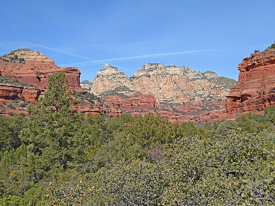
Rugged crags rising above the canyon to the northwest
This popular hike ascends beautiful Boynton Canyon accompanied by great views of the red rock walls lining the canyon. The hike ends near the head of a dramatic box canyon beneath the east side of Bear Mountain. Side trips include a visit to the Boynton Vortex and the Subway Cave.
- Distance: 6.9 - 7.4 miles (RT)
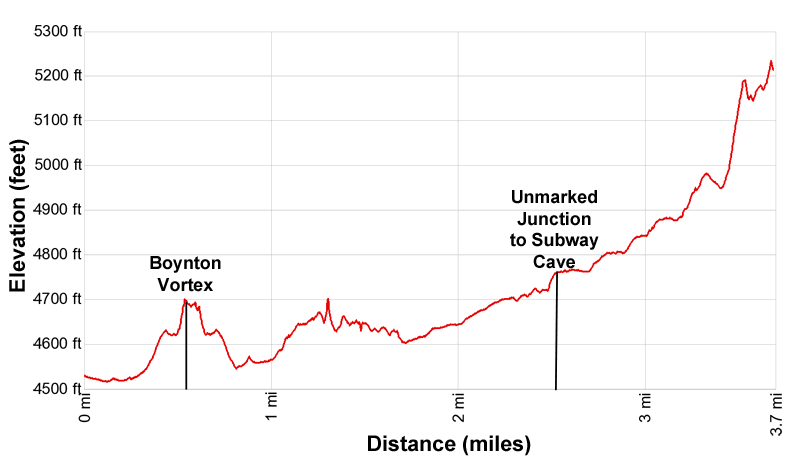
- Elevation: 4,515-ft. at Trailhead
Maximum elevation - 5,235-ft. - Elevation Gain: 720-ft.
- Difficulty: moderate
- Basecamp: Sedona
- Region: Arizona's Red Rock Country
Trail Description - Boynton Canyon

Note: This trail is also good for a short walk. Simply hike as far as time and energy permit up the beautiful canyon and then return to the trailhead.
The Boynton Canyon trail is located at the northwest end of the trailhead parking area across from the bathroom. (See trailhead directions below.) The day starts with a brief stint along the Deadman’s Pass trail, which heads northeast, accompanied by fine views of Mescal Mountain and the west wall of Boynton Canyon. Turn around for views of Bear Mountain rising above Fay Canyon to the west.
Reach a trail junction at 0.1 miles and turn left (northwest) onto the Boynton Canyon Trail. The Deadman’s Pass trail continues straight ahead. At 0.3 miles reach the junction with the Boynton Vista Trail that climbs to the Boynton Vortex.
The detour to the Vista/Vortex is well worth the time and effort. The overlook at the vortex enjoys terrific views of the surrounding area. Some believe that vortexes radiate energy and visit the sites to meditate, practice yoga or perform rituals. Please be respectful of others when visiting this site.
To visit Boynton Vortex turn right at the junction onto the Vista Trail. The path ascends on moderate grades, briefly levels out and then makes a short, moderately steep climb to the vortex situated atop a bench beneath the Kachina Women, a prominent red rock spire, at 0.55 miles. Here, great views extend west to Bear Mountain rising above Fay Canyon and the red rock formations rimming the west side of Boynton Canyon. To the northeast are views of the formations rising around Deadman’s Pass and beyond. Mescal Mountain rises to the southeast while the Enchantment Resort is seem along the floor of Boynton Canyon.
When you are done visiting the Boynton Vista/Vortex retrace your steps to the junction at 0.8 mile and turn right (north) to continue up Boynton Canyon. The trail now ascends on easy grades along the east side of the canyon above Enchantment Resort, traveling through manzanita, scrub oak and agave. Try to ignore the views of the resort and instead focus on the magnificent red rock walls rimming both side of the canyon.
After reaching a high point at 1.3 miles the trail plateaus and then descends on easy grades toward the canyon floor. Along the way enjoy fine views of the canyon’s red rock walls and the rugged crags towering above the Canyon to the northwest.
At 1.5 miles look for a distinctive cave along the canyon’s east wall that contains a Sinaqua ruin. (Binoculars or a zoom lens on a camera will help you see the ruin.) A short distance beyond you might be able to spot a second, smaller ruin in a cave. The roof of this cave is stained with soot from ancient fires.
At 1.7 reach a junction where trails from the resort connect with the Boynton Canyon trail. Continue straight ahead on the Boynton Trail. A tenth of a mile beyond the path crosses the wash to the west side of the canyon. The trail now ascends on easy grades up the canyon floor, traveling through pinyon, juniper, oak and cypress trees. Openings offer views of the interesting red rock formation rimming both sides of the canyon along with the rugged crags towering above the canyon to the north.
A short distance after crossing the wash a prominent formation juts into the east side of the canyon. Here a small ruin is tucked into an alcove high above the canyon floor. Hikers with sharp eyes will spot more ruins as the path continues up the canyon.
At 2.3 miles the trail curves to the northwest and soon approaches the wash. Here you need to start pay attention is you wish to find the unmarked trail to the Subway Cave. The location of the cave and nearby Sinagua ruins were once a secret. That is no longer the case. The cave is now one of the must visit spots for Instagram junkies traveling to Sedona.
At 2.5 miles reach a large alligator Juniper tree on the left side of the trail. (The location is at 2.0 miles if you didn’t take the detour up the Boynton Vista trail.) The distinctive tree has a branch stretching across the trail. Immediately after the tree the main trail curves to the left (west). To the right is the unmarked spur trail to the Subway Cave, blocked with sticks.
Side Trip to the Subway Cave

Note: The mileage for the side trip to the Subway Cave and nearby Sinagua ruins is not included in the mileage for the Boynton Canyon hike. If taking the detour add 0.9 miles to the hike.
To visit the Subway Cave, step over the sticks and follow the trail to a dry creek bed adjacent to a tree stump. Turn right here on an obvious trail. At the next junction the trail to the right heads steeply uphill to the cave. The trail to the left follows a rugged, steep trail to the Sinagua Ruins. From the ruins you can walk along a narrow, exposed ledge to the cave. (Or vise-versa.)
Total round-trip length of this side trip to visit the cave is 0.8 miles. From the cave there is a view of the ruins. Add 0.1 miles to the distance if you travel along the exposed ledge to the ruins. If you visit the ruins, treat them with respect. Do not touch or disturb anything at the site.
Don’t expect solitude when visiting the cave. The steep trail to the cave and exposed ledge leading to the ruins is not recommended for the faint of heart of anyone with a fear of heights. The final climb to the cave ascends a very steep slickrock ramp that requires experience hiking on friction pitches.
Continuing up Boynton Canyon

Beyond the Subway Cave turnoff the Boynton Canyon trail takes on a different character, now traveling through pine trees that slowly give way to oak and maple trees as the path gains elevation. The shade is welcomed on a hot day and the fall colors are lovely in late October.
The path initially ascends on easy grades that grow steeper further up the canyon. Openings in the forest offer fine views of the red rock walls and multi-hued pinnacles and buttes rimming both sides of the canyon.
At 3.0 miles the trail enters the box canyon formed by the cliffs along the east side of Bear Mountain. Here dramatic views open to the near vertical walls soaring above the canyon floor. Sections of the trail now become rockier.
At 3.6 miles the trail curves to the right (north) and climbs steeply up the north side of the canyon. Great views open to the pour-off at the head of the canyon and the massive, sheer walls forming the box.
Reach the end of the trail at 3.7 miles where a sign asks hikers to protect the fragile environment by not proceeding any further. Find a place to sit and take in the views. When you are done enjoying the box canyon turn around and retrace your steps to the trailhead.
Elevation Profile
Driving Directions
Driving Directions from Sedona: From the traffic circle at the intersection of Arizona State Roads 89A and 179 head west on Arizona 89A for 3.0 miles and then turn right (north) on Dry Creek Road. Follow Dry Creek Road for 2.0 miles to an intersection. Here Dry Creek Road turns right. We continue straight ahead on the Boynton Pass Road for 2.5 miles to a “T” intersection. Turn right at the intersection on Boynton Canyon Road. (The Boynton Pass Road continues to the left). Drive 0.1 miles on Boynton Canyon Road and then turn right (east) into the Boynton Canyon trailhead parking area.
The spur road to the parking area passes the trailhead, located across from the bathroom. Note: a Red Rock Pass, America the Beautiful Interagency Pass, Golden Age Pass or Golden Access Pass is required to park in the lot. Red Rock Daily passes are $5, weekly passes are $15 and annual passes are $20. The passes can be purchased in many shops around Sedona or online.
The Boynton trailhead parking lot fills early in the day. If the parking lot is full, overflow parking is available on the Boynton Pass Road, to the southwest of the “T” intersection with the Boynton Canyon Road. (You will also need a pass to park here.)
Trail Resources
- Trail Photo Gallery
- Trail Maps
- Basecamp(s) Information: Sedona
- Region Information: Arizona's Red Rock Country
- Other Hiking Regions in: Arizona