Details: Hoover Lakes 
Distance: 5.8 - 11.8 miles (round trip)
Hoover Lakes Wilderness Area, Humboldt-Toiyabe National Forest, near Lee Vining in California's Southeastern Sierra
Hike Facts
- Distance: 5.8 - 11.8 miles (round trip)
- Elevation: 7,990-ft. - 9,823-ft.
- Elevation Gain: 955-ft. - 1,833-ft.
- Difficulty: moderate-strenuous
- Trail Highlights: See Trail Intro
- Basecamp(s): Lee Vining / Bridgeport
- Region: California's Southeastern Sierra
Multi-hued peaks form the backdrop of the Hoover Lakes, a pair of alpine jewels ringed by meadows and talus slopes. Along the way the trail traverses lovely meadows, climbs beside rushing streams and visits pretty Green Lake and beautiful East Lake.
Trailhead to Green Lake
Distance from Trailhead: 5.8 miles (round trip)
Ending/Highest Elevation: 8,945-ft.
Elevation Gain: 1,045-ft.
The Hoover Lakes trail starts on the west side of the trailhead parking lot, just to the left of the bathroom. Follow the trail as it travels on easy grades through a forest of pines, junipers and aspen along the hillside above the Green Creek Road and the Green Creek Campground. The trail then drops down to meet the road at 0.6 miles, just beyond the campground. Gabbro Peak (11,033-ft.) dominates the skyline to the southwest.
Turn right (southwest) and travel along the road for a quarter mile to the continuation of the trail. The trail restarts where the road curves right (northwest) toward a private residence.
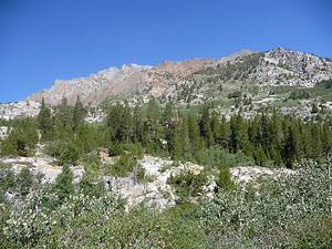
The path ascends on moderate grades along the west side of the West Fork of Green Creek, which is mostly hidden by dense willows and aspens. At 1.3 miles the trail climbs a rocky hillside on a series of steep switchbacks and then continues ascending the valley on more moderate grades through forest, over granite outcroppings and across open areas covered in scrub growth. Open areas provide great views of Monument Ridge towering above the trail to the right (northwest) and the peaks lining the northwestern wall of Glines Canyon.
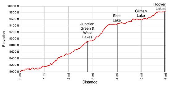
At 2.75 miles reach the junction with the trail heading to Green and West lakes, branching to the right (northwest). Our trail heads curves to the left (south), traveling through forest on easy grades. Glimpses of Green Lake are seen through the trees to the right (west) of the trail.
To East Lake
Distance from Trailhead: 8.0 miles (round trip)
Ending/Highest Elevation: 9,458-ft.
Elevation Gain: 1,468-ft.
Ford or rock hop across the outlet of Green Lake at 2.9 miles. The crossing can be tricky during high water. Past the outlet moderately steep switchbacks climb the hillside to the southeast of the lake, gaining 500-ft. in 0.7 miles. Along the way the trail crosses the creek linking East and Green lakes twice. These crossings can be challenging early in the season or during periods of high water.
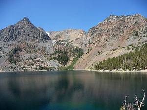
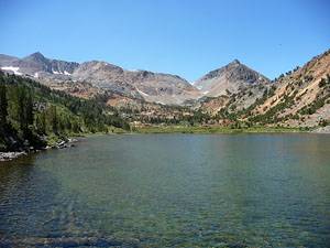
At the top of the switchbacks the trail crests the rim of the East Lake basin and then travels through forest on easy grades, arriving at a ford of East Lake’s outlet stream of 3.9 miles. A short distance beyond the outlet the path reaches the north end of East Lake (9,458-ft.), 4.0 miles from the trailhead.
Follow the trail as it contours above the lake’s eastern shore on rock ledges. This section of the trail enjoys stunning views of colorful Gabbro (11,033-ft.), Page and Epidote (10,964-ft.) peaks towering above lake’s western shore.
To the Hoover Lakes
Distance from Trailhead: 11.8 miles (round trip)
Ending/Highest Elevation: 9,823-ft.
Elevation Gain: 1,833-ft.
At 4.7 miles the trail reaches the southern end of East Lake and then continues its journey south on easy grades, curving around and above the east side of Nutter Lake before dropping down to the lake’s southern shore at 4.9 miles. Nutter Lake is a tiny jewel with glorious views of Page and Gabbro Peaks reflected in its still waters.
Beyond Nutter the path wanders through a rocky landscape with scattered trees, crossing into the East Fork of Green Creek drainage along the way. At 5.0 miles views open to Gilman Lake (9,486-ft.) tucked in a rocky bowl far below the trail. The rugged crags and jagged western ridge of Dunderberg Peak (12,374-ft.) towers above lake’s eastern shore.
As the trail veers away from the lake as it continues south, descending slightly to contour around the western shore of a small tarn. Past the tarn the trail climbs steeply up a rocky hillside to a crossing of Gilman’s inlet stream. On the other side of the stream the trail curves to the southwest and climbs a series of steep switchbacks through rocky meadows to the rim of the Hoover Lakes basin, gaining 250-ft in 0.4 miles. Views to the north of Gilman Lake and Dunderberg Peak and to the west of Epidote Peak will help take your mind off the stiff climb.
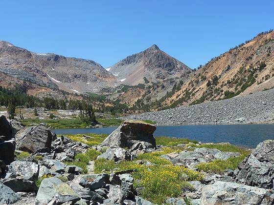
At 5.6 miles the trail reaches the lower end of the Hoover Lakes basin and shortly thereafter the northeast end of the first Hoover Lake (9,819-ft.), 5.7 miles from the trailhead. The lakes lie nestled in a long basin surrounded by colorful peaks. Epidote Peak rises to the west while the peaks and ridges along the Pacific Crest frame the skyline to the southwest. Pretty wildflowers grow among the boulder fields and meadows ringing the lake shores.
The trail wanders through talus around the southeast side of the first lake to a stream crossing connecting the lower and upper lakes. I suggest that day hikers leave the trail right before the stream crossing and walk along the creek to the northeast end of the second Hoover Lake (9,823-ft.), 5.9 miles from the trailhead. This is a good turn around point for day hikers. A rock outcropping at the end of the lake offers a great place to relax in the sun and enjoy the stunning basin.
Backpackers will want to cross the stream and follow the trail as it traverses the talus slopes lining the northwestern shore of the upper lake. At the end of the second lake the trail fords the inlet stream and ascends through forest to the junction with the Virginia Lake trail, 6.8 miles from the trailhead. Take the right (northwest) fork to Summit Lake. The trail climbs through meadows along the lake’s outlet stream, reaching Summit Lake (10,183-ft.) 7.2 miles from the trailhead. The trail to the left (southeast) climbs an 11,000-ft. divide to the Virginia Lakes, gaining over 1,000-ft. in 1.7 miles.
The aptly named Summit Lake is nestled in a saddle along the Pacific Crest. Camiaca Peak (11,739-ft.) rises to the north. The southern shore is flanked by a minor peak on a ridge extending from Excelsior Mountain (12,446-ft) to the south. Past Summit Lake the trail drops into the backcountry of Yosemite National Park.
Elevation Profile
Driving Directions
From Bridgeport: Drive south on Highway 395 for 4.8 miles and turn left (south) on the gravel Green Creek Road. Follow the road for 2.8 miles to the intersection with the Virginia Lakes Road. Turn right (southwest) on Green Creek Road and continue along the road for 5.2 miles to the trailhead parking lot, located on the left side of the road. The trailhead is to the left of the bathroom.
From Lee Vining: Drive north on Highway 395 for 20.5 miles and turn right (southwest) on the Green Creek Road. Follow the road for 2.8 miles to the intersection with the Virginia Lakes Road. Turn right (southwest) on Green Creek Road and continue along the road for 5.2 miles to the trailhead parking lot, located on the left side of the road. The trailhead is to the left of the bathroom.
Trail Resources
Trail Intro / Trail Photo Gallery / Trail Map
Basecamp(s) Information:
Lee Vining / Bridgeport
Region Information:
California's Southeastern Sierra
Other Hiking Regions in:
California