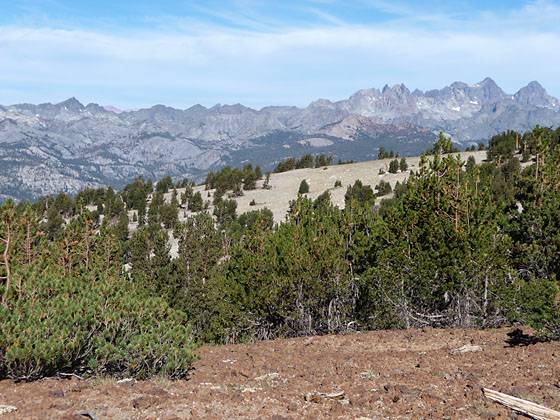
Details: Mammoth Crest 
Distance: 4.4 - 13.2 miles (loop)
John Muir Wilderness Area, Inyo National Forest, near Mammoth Lakes in California's Southeastern Sierra
Hike Facts
- Distance: 4.4 - 13.2 miles (loop)
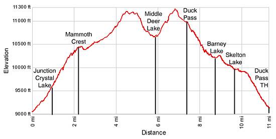
- Elevation: 9,025-ft. - 11,215-ft.
- Elevation Gain: 1,400-ft. - 2,765-ft.
- Difficulty: strenuous
- Trail Highlights: See Trail Intro
- Basecamp(s): Mammoth Lakes
- Region: California's Southeastern Sierra
This scenic trail climbs along the Mammoth Crest, with fabulous views of the Mammoth Lakes, the Ritter Range and Middle Fork San Joaquin Canyon. Beyond the Crest the trail drops to scenic Deer Lakes where a route leads to the Duck Pass Trail, creating a long, interesting loop hike.
Trailhead to the Mammoth Crest

Distance from Trailhead: 4.4 miles (round trip)
Ending/Highest Elevation: 10,425-ft.
Elevation Gain: 1,400-ft.
From the north end of the parking area (see driving directions) follow the Crystal Lake/Deer Lake trail as it ascends northwest through fir/pine forest above summer cabins. After 0.25 miles the trail turns southwest and climbs moderately steep switchbacks up the hillside rising along the northwest side of Lake George. As you climb enjoy intermittent views of Lake George and the Mammoth Lakes basin to the east.
After hiking for a mile reach the junction with the Crystal Lake trail, branching to the left. Continue straight ahead. The ascent continues up the hillside through thinning trees with ever improving views of the lakes basin. An overlook at the end of a sandy switchback provides bird’s eye views of Horseshoe Lake, to the north.
After passing the John Muir Wilderness sign and a trio of unsigned trails (heading right), reach the Mammoth Crest at 2.2 miles. Spectacular views extend northwest to the Ritter Range, where Banner Peak, Mount Ritter and the Minarets dominate the skyline. Directly to the west is the Middle Fork of the San Joaquin River Canyon.
To Deer Lakes

Distance from Trailhead: 11.5 miles (round trip)
Ending/Highest Elevation: 11,190-ft.
Elevation Gain: 2,165-ft.
The sandy trail now turns south and travels on easy grades through a barren landscape along the west side of the Crest. Progress along this section of the trail is slow as you are compelled to stop often to soak in the views. Along the way you will be tempted to take a side trip to the top of the crest where views extend east to the glistening Mammoth Lakes set amid trees and framed by red ridges.
At 3.7 miles the trail curves east and begins an ascending traverse along the west side of the crest. Soon the path enters a scattered forest of stunted whitebark pines and the grade steepens. The high point on the crest (11,190-ft.) is reached 4.3 miles from the trailhead.
Just beyond the high point the trail climbs along crags near the edge of the crest. Hammil and tiny Way Lakes can be seen far below the trail to the east.
The sandy trail now descends steeply to Deer Lake, arriving at the south shore of Middle Deer Lake (10,680-ft.) at 5.75 miles. The Deer Lakes are set amid rocky meadows beneath Blue Crag, a distinctive summit along the Mammoth Crest. The best campsites are located to the southwest near the creek connecting the Lower and Middle Deer Lake.
Completing the Loop

Distance from Trailhead: 13.2 miles (loop)
Ending/Highest Elevation: 11,215-ft.
Elevation Gain: 2,765-ft.
This is the end of the maintained trail. Hikers uncomfortable following routes should turn around and return to the George Lake trailhead. Parties with the time, energy and good weather will want to complete the loop by following a use trail that climbs the hillside at the east end of Middle Deer Lake to the upper basin and then travels above the northern shore of Upper Deer Lake (10,884-ft.).
At the upper lake, look for an obvious saddle on the ridge at the northeast end of the lake. Climb the steep talus slope to the saddle. There are a few vestiges of a use trail going up the slope. Beyond the saddle the grade abates as the trail continues its ascent on a boot beaten path through meadows, heading for the low spot on the divide (11,215-ft.). From the top of the divide, views open the scenic peaks and ridges forming the eastern wall of the Duck Lake basin.
The route now descends east/southeast through meadows and trees, staying to the south (right) of the ridge. Before long the use trail fades and becomes hard to follow. If you lose the trail just continue to descent to the southeast. Soon you will hit the maintained trail coming down from Duck Pass and leading to the southwest end of Duck Lake, 7.4 miles from the trailhead.
If you were able to remain on the correct route you will hit the Duck Pass trail just to the southwest of Duck Pass. Otherwise you will need to turn left (northeast) and ascend to the pass.
Wherever you hit the maintained trail I recommend taking a break before crossing the pass. The best place is 0.1-0.2 miles down from the pass in the rocky meadows just below the trail. From this vantage point the huge 222-acre Duck Lake, one of the largest natural lakes in Eastern Sierras, lies cradled in a huge cirque of jagged 11,000-ft. peaks and ridges. Smaller Pika Lake is tucked beneath the rugged cliffs to the southeast of Duck Lake. Stunning Silver Peak and the Silver Divide fill the skyline to the southwest.
After admiring the views ascend to Duck Pass (10,800-ft.), 7.4 miles from the trailhead. On the northeast side of the pass the trail descends steep, rocky switchbacks through small copses of stunted whitebark pines to the head of Barney Lake, along the way enjoying views down the pretty Mammoth Creek Valley. Mammoth Mountain (11,030-ft.) dominates the skyline to the northwest.
Barney Lake lies in a stark bowl at the head of the valley. Rocky meadows sprinkled with scrub willows and stunted pines line the eastern shore. Scree fields tumble down the sheer slopes along the west side of the lake.
Follow the trail as it travels along the right (east) side of Barney Lake and then crosses the outlet stream on two wood logs at 8.5 miles. Before and after the crossing spur trails head right along the outlet stream to pretty Red Lake, this tiny lake is situated to the northeast of Barney Lake.
At the foot of the lake climb a low hill and then descend through meadows and forested hillsides to the western shore of Skelton Lake (9,924-ft.), at 9.4 miles. Pines grow amid small meadows and on granite outcroppings around the lake shore. A craggy ridge dominates the skyline to the east of the lake.
A short distance past the lake the grade eases a bit as the trail travels along the southwest (left) side of a pretty meadow and the stream linking Skelton and Arrowhead Lakes. Past the meadows the descent resumes through forest and along granite outcroppings. Openings in the trees provide nice views of the ridge rising along the east side of the valley.
At 10.1 miles reach the junction with the trail to Arrowhead Lake branching right. The Duck Pass trail continues straight ahead. The trail now descends forested hillsides on moderately steep switchbacks to the Duck Pass trailhead. At this point you have walked 11.0 miles.
If you have not arranged a car shuttle, walk northwest through the Cold Water Campground for 0.7 miles to the Lake Mary Road and take a left. Follow the Lake Mary Road along the west side of Lake Mary for 1.1 mile to the Lake George Road and turn left. Head up the road for 0.3 miles to the parking lot where you left your vehicle. The distance for the complete loop is 13.2 miles.
Elevation Profile
Driving Directions
From Mammoth Lakes: Head west on Highway 203 / Main Street. Main Street changes its name to Lake Mary Road at the intersection with Minaret Road. Follow the Lake Mary Road for 3.6 miles to a fork just before Lake Mary. (From here follow the signs to Lake George.) Turn right and follow the right fork of Lake Mary Road along the east side of the lake for 0.3 miles to an intersection. At the intersection turn left onto the Around Lake Mary Road toward Lake George. (Continuing straight ahead will take you to Lake Mamie.) Follow the road along the north side of Lake Mary for 0.3 miles to a “T” intersection. Turn right and follow the signs to Lake George. There is a large hiker’s parking lot for day and overnight parking 0.3 miles up the road. The trailhead is located at the north end of the parking area.
Trail Resources
Trail Intro / Trail Photo Gallery / Trail Map
Basecamp(s) Information:
Mammoth Lakes
Region Information:
California's Southeastern Sierra
Other Hiking Regions in:
California