Details: Mono Pass 
Distance: 7.0 - 8.5 miles (round trip)
John Muir Wilderness Area, Inyo National Forest, near Mammoth Lakes in California's Southeastern Sierra
Hike Facts
- Distance: 7.0 - 8.5 miles (round trip)
- Elevation: 10,200-ft. - 12,060-ft.
- Elevation Gain: 1,860-ft. - 2,030-ft.
- Difficulty: strenuous
- Trail Highlights: See Trail Intro
- Basecamp(s): Mammoth Lakes / Bishop
- Region: California's Southeastern Sierra
This stiff climb to Mono Pass features fine views of the Little Lakes Basin, Ruby Lake, the Mono Recesses and Pioneer Basin.
Trailhead to Mono Pass
Distance from Trailhead: 7.0 miles (round trip)
Ending/Highest Elevation: 12,060-ft.
Elevation Gain: 1,860-ft.
From the Mosquito Flats parking area head south, ascending on gentle grades along the west side of Rock Creek. In a short distance the grade steepens as the trail climbs a small hill above Mack Lake. The lake, which is difficult to see, is tucked below the trail in a gully.
At the top of the hill reach a trail junction at 0.5 miles. Turn right (southwest) to reach Mono Pass. The trail to the left heads up the Little Lakes Valley to Morgan Pass.
Follow the trail as it ascends the eastern slope of Mt. Starr (12,835-ft.) on rocky switchbacks through scattered pines. Along the way pass a junction where a stock trail joins the main trail to the pass.
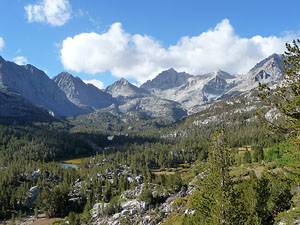
As you climb overlooks along the trail showcase the jagged granite peaks surrounding the beautiful Little Lakes valley, including Mt. Morgan (13,748-ft.), Pyramid Peak (12,866-ft.), Bear Creek Spire (13,740-ft.) and Mt. Dade(13,600-ft.). Below, Marsh, Heart and Box Lakes are set amid small meadows and surrounded by forest.
The grade abates as the trail climbs above a scrub choked drainage and then reaches a pretty meadow with a meandering stream, 1.9 mile from the trailhead. At the northwest end of the meadow a spur trail heads southwest to Ruby Lake. To the west, the craggy pinnacles and sheer ridges of Mt. Mills (13,451-ft.) fill the skyline.
The quarter mile detour to Ruby Lake makes for a nice rest stop. I recommend taking the spur trail on the return trip if time and energy allow.
Beyond the junction the grade steepens as the trail climbs a series of switchbacks above Ruby Lake. This section of the trail enjoys fine views of Ruby Lakes tucked in a deep basin beneath sheer granite walls. To the south the high peaks at the head of the Little Lakes Valley dominate the skyline.
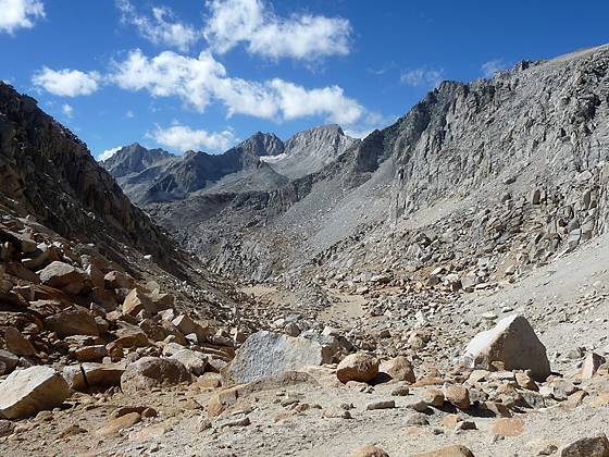
At the top of the switchbacks the path traverses to the west and then crosses Mt. Starr’s southwest ridge at 2.9 miles. On the other side of the ridge the path turns north and climbs a steep scree covered slope high above the east side of a deep drainage. The rugged serrated northeast ridge of Mt. Mills rims the drainage to the west. Take periodic breaks from the stiff climb to enjoy ever improving views of the lofty granite giants rising to the south.
At 3.1 miles the trail crosses to the west side of the drainage, continuing its stiff ascent up a rocky gully through a moonscape of boulders and pulverized granite. Soon the grade abates and reaches Mono Pass (12,060-ft.), 3.5 miles from the trailhead.
To the Scenic Overlook Beyond Mono Pass
Distance from Trailhead: 8.5 miles (round trip)
Ending/Highest Elevation: 11,890-ft.
Elevation Gain: 2,030-ft.
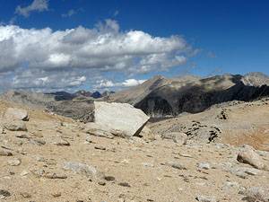
If time and energy allow descend from the pass to north end of Summit Lake (11,890-ft.) on a sandy trail, losing 150-ft. over 0.6 miles. During the descent enjoy nice views of Mt. Starr to the east. A short distance beyond the end of the lake the trail begins descending toward Trail Lake. Leave the trail at this point and climb the ridge to the left (northwest) until you reach a good spot with views of the peaks rising above the Mono Recesses and Pioneer Basin to the northwest, about 4.25 miles from the trailhead. This is a great lunch spot and a good turn around point for a day hike.
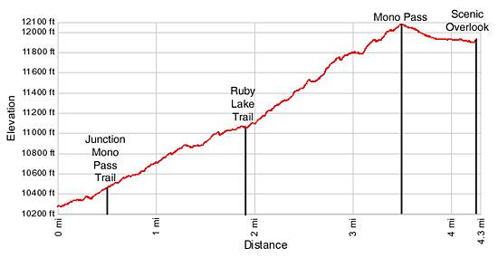
Elevation Profile
Driving Directions
From Mammoth Lakes: Drive east on Main Street / CA 203 E for 3.1 miles and turn right onto the entrance ramp for Highway 395 S. Follow Highway 395 S for 15 miles to Tom’s Pace (aka Rock Creek Road). Turn right (south) on Rock Creek Road and drive 10.5 miles up the canyon to the Mosquito Flats Parking area at the end of the road. The final 1.25 miles of the road is single lane with occasional pullouts. The trailhead is located at the south end of the parking lot.
From Bishop: Follow Highway 395 N north for 24 miles to Tom’s Place (aka Rock Creek Road). Turn left (south) on Rock Creek Road and drive 10.5 miles up the canyon to the Mosquito Flats Parking area at the end of the road. The final 1.25 miles of the road is single lane with occasional pullouts. The trailhead is located at the south end of the parking lot.
This trailhead is extremely popular and the parking area fills early in the morning (8:30am-9am). Overflow parking is available 0.3 miles back down the road. On busy weekends you may need to drive much further back on the road to find an empty parking space.
Trail Resources
Trail Intro / Trail Photo Gallery / Trail Map
Basecamp(s) Information:
Mammoth Lakes / Bishop
Region Information:
California's Southeastern Sierra
Other Hiking Regions in:
California