Details: Redwood Canyon Loop 
Distance: 7.3 - 9.6 miles (loop)
Sequoia-Kings Canyon National Park, near Lodgepole in California's Southwestern Sierra
Hike Facts
- Distance: 7.3 - 9.6 miles (loop)
- Elevation: 6,220-ft. - 6,414-ft.
- Elevation Gain: 194-ft. - 1,455-ft.
- Difficulty: moderate
- Trail Highlights: See Trail Intro
- Basecamp(s): Lodgepole
- Region: California's Southwestern Sierra
Leave the crowds behind and enjoy a peaceful hike through one of Sequoia-Kings Canyon National Park’s largest sequoia groves.
Hart / Redwood Creek Loop
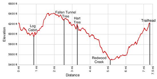
Distance from Trailhead: 7.3 miles (loop)
Ending/Highest Elevation: 6,414-ft.
Elevation Gain: 919-ft.
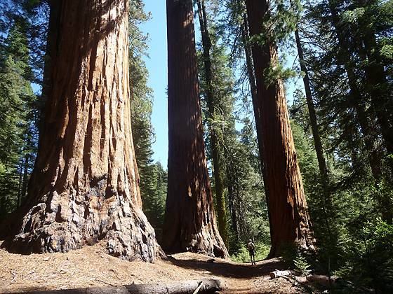
The trail, which south end of the parking area, descends on a switchback through a mixed conifer forest scattered with sequoias to a trail junction at 0.3 miles. A group of giant sequoias tower above the intersection. The Redwood Creek trail, to the right, is the return leg for the hike. Turn left on to the Hart Tree trail and continue the descent through some awesome sequoias.
Cross fern-lined Barton Creek at 0.5 miles and reach the Log Cabin, a hollowed out sequoia lying on its side, at 0.8 miles. The cabin is near a few large stumps that mark the remains of Barton Post Camp, an old logging site from the 1800’s.
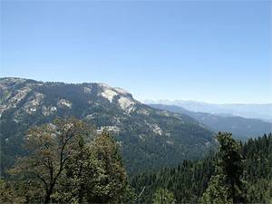
Beyond the cabin pass a few more sequoias and then begin an ascent through forest on moderate grades, heading southeast. Openings in the trees offer nice views of Redwood Mountain. At 1.8 miles the trail crests a granite knob where views open to Big Baldy (8,206-ft.) to the southeast.
The trail descends from the knob, passing the southern end of pretty Hart Meadow and then drops, on gentle grades, through a great collection of giant sequoias. Walk through the Fallen Tunnel Tree, a hollowed out giant sequoia, at 2.5 miles, and continue the scenic decent to the pretty East Fork Redwood Creek at 3.1 mile. Wildflowers line the creek and grow amid the sequoias. A small waterfall cascades over rocks just above the trail.
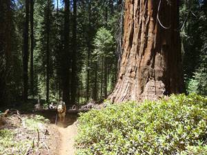
Rock hop across the creek and follow the trail as it turns southwest. In a short distance reach the spur trail to the Hart Tree, 3.2 miles from the trailhead. The short, steep spur trail climbs to the Hart Tree in 0.1 miles. The impressive 278-ft. tall tree with a ground circumference of 75.3-ft is the 24th largest giant sequoia in the world and named after Michael Hart who discovered the tree around 1880. A few nearby logs provide a nice place to rest and admire this amazing specimen.
Return to the main trail and continue the descent on easy to moderate grades through a mixed forest with a wonderful collection of giant sequoias. Along the way the trail crosses a small stream (3.6 miles). Openings in the trees offer the opportunity to see trees in their entirety, from the base to the top of the canopy.
At 4.6 miles the trail curves to the northwest and soon passes a spur trail to the Fallen Goliath. Just before reaching Redwood Creek pass a few massive sequoias. The grade abates as the trail crosses Redwood Creek, the low point (5,495-ft.) of the loop, at 5.1 miles.
Just beyond the crossing reach the junction with the Redwood Creek Trail. The trail to the left leads to campsites. We turn right (north) and follow the Redwood Creek Trail on easy grades along the west side of the creek, passing some large sequoias along the way.
Reach the junction with the Sugar Bowl Trail, heading left (southwest) at 5.3 miles. Continue straight ahead on the Redwood Creek trail for 1.7 miles, climbing on easy to moderate grades, initially beside the creek and later on the hillside above it. Photogenic sequoias, scattered amid the mixed forest, tower above the scenic trail. At times the forest thins, permitting hikers to view an entire tree from a nice distance. In other areas the dense foliage makes it difficult to see more than the base of these amazing giants.
At 7.0 miles reach the junction with the Hart Trail. Turn left and ascend the broad trail back to the trailhead, at 7.3 miles, enjoying the giant sequoias along the final section of the trail.
Sugar Bowl Trail
Distance from Trailhead: 9.6 miles (loop)
Ending/Highest Elevation: 6,950-ft.
Elevation Gain: 1,455-ft.
Hiker looking for a longer hike can turn left on the Sugar Bowl Trail instead of following Redwood Creek back to the parking area. The trail ascends through mixed forest to the Sugar Bowl, a dense stand of mature and young sequoias. As the trail climbs views open to Big Baldy to the southeast and Buena Vista Peak across the valley.
Cross a small stream and follow the trail as it switchbacks up a dry hillside to the crest of Redwood Mountain (6,950-ft.). The trail now descends along the ridge, passing through mixed forest and smaller sequoias to the parking area, 9.6 miles from the trailhead. The elevation gain for the Hart / Sugar Bowl loop is 1,455-ft.
Elevation Profile
Driving Directions
From Lodgepole in Sequoia: Follow the General’s Highway (CA 198) north for 21 miles to the Quail Flat / Hume Lake junction on the northeast side of the road. Opposite the sign for Quail Flat is an unmarked road. Turn left (west) on the unmarked road. Follow the bumpy, single lane dirt road as it descends for 2 miles to a junction. Turn left at the junction into a parking area. The trailhead is located at the south end of the parking area.
From the intersection of Highway 180 and the General’s Highway (CA 198): Follow the General’s Highway south for 3.6 miles to the Quail Flat / Hume Lake junction (7 miles south of Grant Grove) on the northeast side of the road. Opposite the sign for Quail Flat is an unmarked road. Turn right (west) on the unmarked road. Follow the bumpy, single lane dirt road as it descends for 2 miles to a junction. Turn left at the junction into a parking area. The trailhead is located at the south end of the parking area.
Trail Resources
Trail Intro / Trail Photo Gallery / Trail Map
Basecamp(s) Information:
Lodgepole
Region Information:
California's Southwestern Sierra
Other Hiking Regions in:
California