Details: Monarch Lake 
Distance: 9.0 miles (round trip)
Sequoia-Kings Canyon National Park, near Mineral King in California's Southwestern Sierra
Hike Facts
- Distance: 9.0 miles (round trip)
- Elevation: 7,840-ft. - 10,390-ft.
- Elevation Gain: 2,550-ft.
- Difficulty: moderate-strenuous
- Trail Highlights: See Trail Intro
- Basecamp(s): Mineral King
- Region: California's Southwestern Sierra
Beautiful Monarch Lakes lie cradled in scenic bowl at the foot of Sawtooth and Mineral Peaks. A moderately-steep trail to the lake climbs through meadows, red fir forest and avalanche-scoured slopes and features fine views of the Mineral King valley.
Monarch Lake
The trail to Monarch Lake starts with a steep climb up a brush covered hillside. As the trail ascends enjoy ever improving views south up the East Fork Kaweah River Valley to Vandever Mountain (11,947-ft.) and Farewell Gap. Soon the trail curves east and climbs along the north slopes of the Monarch Creek drainage. At 0.3 miles the trail takes a sharp turn to the left (northwest) and ascends a long switchback. A rock outcropping at the turn provides nice views of a waterfall on Monarch Creek.
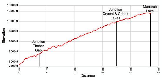
Reach a junction at 0.7 miles where the path to Timber Gap splits off to the left (north). Turn right and follow the trail marked for Monarch and Crystal Lakes as it heads east, ascending the steep slope above Monarch Creek. In a short distance views open to the jagged crags lining the northern side of the drainage.
After gaining 920-ft. over 1.3 miles the grade eases as the trail traverses pretty Ground Hog meadows, home to a population of yellow-bellied Marmots. Monarch Creek tumbles down the steep wall at the head of the meadow.
Ignore the faint trail branching to the left. This is an old, unmaintained trail climbing the unstable talus slopes above the north side of the meadow. Instead follow the main trail as it turns south and rock hops cross Monarch Creek. On the other side of the creek there is a nice shady rest spot and a good place to fill water bottles.
Beyond the crossing the trail climbs a series of moderately steep switchbacks through a forest of red fir and western white pines to the top of the ridge on the south side of the valley, gaining 930-ft in 1.7 miles. Along the way openings in the tree provide views north toward Timber Gap and to the west down the Mineral King valley. At the top of the ridge wonderful views extend southwest to the peaks surround Eagle and Mosquito lakes area.
On the other side of the ridge the trail crosses into the Chihuahua Bowl and soon reaches a junction (3.5 miles) where the trail to Cobalt and Crystal Lake split right (southeast). The trail to Monarch Lake continues straight ahead.
After a few more switchbacks the trail again crosses the ridge, returning to the Monarch Creek drainage amid a nice stand of fox tail pines. At the ridge crossing be sure look southwest for great views of colorful White Chief Canyon.
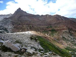
The trail now heads east, ascending on easy to moderate grades along Monarch Canyon’s rugged northern slope high above Monarch Creek. Along the way enjoy views of Timber Gap, the sheer ridges lining the Canyon’s north wall and Sawtooth Peak (12,343-ft.).
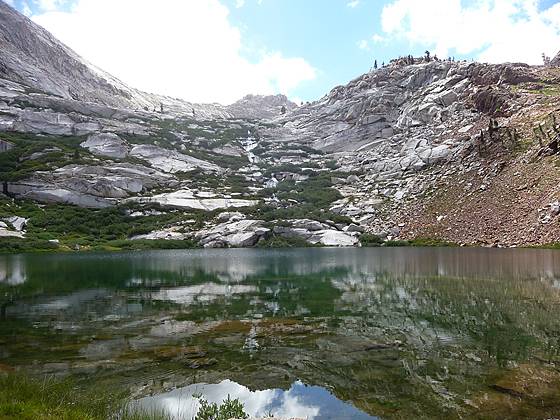
Toward the head of the canyon the trail passes through a scattered grove of windswept fox tail pines and curves right (south) at 4.3 miles, following the course of Monarch Creek cascading through the meadows below the trail. Soon the trail turns left (east) again, crosses the braided creek and climbs to the western shore of Lower Monarch Lake (10,390-ft.), 4.5 miles from the trailhead.
The picturesque lower lake sits in a deep bowl beneath the rugged red, brown and orange metamorphic rock slopes of Mineral Peak (11,615-ft.). Waterfalls tumble down the rocky granite headwall at the east end of the lake. Talus slopes cascade from Sawtooth Peak’s sheer western ridge to the lake’s northern shoreline.
Over used campsites are located on the rocky knoll to the west of the lake. The camping area includes a bear box and partially screened pit toilet.
A use trail heads around the northern side of the lower lake and climbs the steep headwall to Upper Monarch Lake (10,640-ft.) in 0.25 miles. Beyond the lower lakes, a very strenuous, unmaintained trail climbs 1200-ft. in 1.3 miles up slippery, scree covered slopes to Sawtooth Pass, which features amazing views of the Mineral King area. The difficulty of this trail is not to be under estimated, it’s a real slog. Most people climb to the pass from the east via Lost Canyon and descend to Monarch Lakes as part of a multiday backpacking trip.
Elevation Profile
Driving Directions
From Visalia: Follow Highway 198 East for 31.5 miles to the Mineral King Road. (There is a small green sign on the right side of the road that read “Mineral King 25 miles”.) Turn right onto the Mineral King Road and follow the narrow, winding road for 23.3 miles to the Timber Gap / Sawtooth parking areas. Parking areas are located on both sides (north and south) of the road. The trailhead is located at the north end of the north parking area. The bathroom is located at the south end of the south lot. There is also a payphone at the southwest end of the north lot.
Trail Resources
Trail Intro / Trail Photo Gallery / Trail Map
Basecamp(s) Information:
Mineral King
Region Information:
California's Southwestern Sierra
Other Hiking Regions in:
California