Details: Buckskin Pass 
Distance: 3.4 - 9.2 miles (round trip)
Maroon-Snowmass Wilderness, White River National Forest, near Aspen in Central Colorado
Hike Facts
- Distance: 3.4 - 9.2 miles (round trip)
- Elevation: 9,580-ft. - 12,462-ft.
- Elevation Gain: 496-ft. - 2,882-ft.
- Difficulty: strenuous
- Trail Highlights: See Trail Intro
- Basecamp(s): Aspen
- Region: Central Colorado
This popular trail climbs to a 12,462-ft. pass with panoramic views of the 14,000-ft. peaks towering above the heart of the Maroon Bells-Snowmass Wilderness. Visual delights along the trail include lofty peaks, two stunning lakes and beautiful alpine meadows.
Trailhead to Crater Lake / West Maroon Junction
Distance from Trailhead: 3.4 miles (round trip)
Ending/Highest Elevation: 10,076-ft.
Elevation Gain: 496-ft.
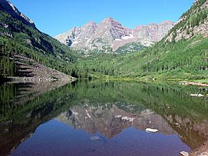
Few trails can surpass the stunning views from the start of the Buckskin Pass hike at the foot of Maroon Lake. Mirrored in the lake’s waters are the iconic Maroon Bells (14,156-ft. and 14,014-ft.), towering above the head of the valley. Pyramid Peak’s (14,018-ft.) jagged crags rise to the south while the crimson spires of the Sievers Mountains form the backdrop for beautiful aspen groves to the north.
Follow the Maroon-Snowmass trail along Maroon Lake’s north (right) shore to a junction at the "Deadly Bell's Kiosk" near the head of the lake. Progress will be slow along this section of the trail as the gorgeous scenery invites frequent stops.
At the junction the Scenic Loop Trail branches left. We turn right to stay on the Maroon-Snowmass trail, which ascends a wide rocky path through Aspen and spruce trees along the northwest side of the valley. Openings in the trees offer views of rugged Pyramid Peak rising to the south.
About a mile from the start the moderately steep trail climbs an ancient rock slide forming a natural dam that created Crater Lake. As you reach the top of the slide enjoy wonderful views of the Maroon Bells and the Sleeping Sexton, located on the ridge extending north from North Maroon Peak.
From the top of the slide the trail descends gently toward Crater Lake. Slightly before reaching Crater Lake arrive at a junction at 1.7 miles. Take the right fork, signed for Maroon-Snowmass trail. The West Maroon trail, heading straight ahead, leads to Crater Lake and West Maroon Pass.
Junction to Buckskin Pass
Distance from Trailhead: 9.2 miles (round trip)
Ending/Highest Elevation: 12,462-ft.
Elevation Gain: 2,882-ft.
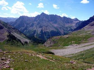
The Maroon-Snowmass trail ascends steeply through aspen and spruce forest for 0.6 miles to Minnehaha Gulch. Breaks in the trees along the lower section of the climb provide nice views of the Maroon Bells, Crater Lake and the West Maroon Valley. As you gain elevation the trees thin and great views open to the west across Minnehaha Gulch to the Sleeping Sexton and North Maroon Peak.
The initial ascent is along the east side of the gulch, a deep ravine channeling a stream. At 2.9 miles the path rock hops across the stream to the west side of the gulch. Beyond the crossing the trail climbs a hillside through pretty meadows and downed trees, toppled by avalanche activity. The meadows offer wonderful panoramas of North Maroon Peak to the southwest and Pyramid Peak to the southeast.
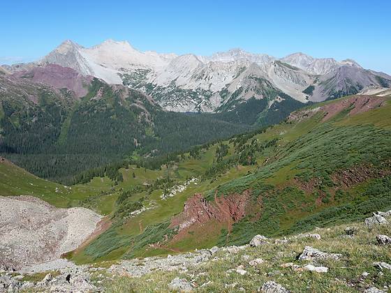
At the end of the gulch the trail climbs a steep gully beside a small stream festoon with wildflowers and emerges onto a beautiful basin clad in alpine meadows. Buckskin Pass, the saddle looming above the head of the steep valley, is now in sight.
Ascend the meadows on a series of switchbacks with wonderful views of North Maroon Peak and the Sleeping Sexton. Pyramid Peak dominates the skyline to the southeast. At 3.75 miles reach a trail junction. Turn left toward Buckskin Pass. The trail to the right heads to Willow Pass. (The hike to Willow is nice but the views from the pass pale when compared to the panorama from Buckskin.)
Beyond the junction the trail heads west and crests a small rise. Ahead the trail is seen zigzagging steeply up to the pass. The final section of the trail climbs 480-ft in just over 0.5 miles. The amazing scenery and hillsides sprinkled with wildflowers invite frequent rest stops and help divert your attention from the stiff ascent.
As you crest Buckskin Pass at 4.6 miles a stunning panorama springs into view. To the west Snowmass Peak, Hagerman Peak and Snowmass Mountain (14,092-ft.) tower above Snowmass Lake. Rugged Capitol Peak (14,130-ft.) and Mount Daly rises to the northwest of Snowmass Mountain. Pyramid Peak (14,018-ft.) and a jagged ridgeline of 13,000-ft. peaks dominate the skyline to the east while the Sleeping Sexton and Maroon Bells rise above the ridge to the south.
On the west side of the pass the trail can be seen winding its way downhill toward Snowmass Lake. See the information on the Four Pass Loop backpacking trip for information on the trail beyond Buckskin pass.
After soaking in the view return the way you came, enjoying the wonderful views as you descend.
Buckskin Pass is a very popular hike. My advice is to get an early start so you can enjoy a degree of solitude at the pass, have plenty of time to soak in the scenery and then descend before the onset of afternoon thunderstorm, a common occurrence in the Rockies.
Note: Backpackers will find a variety of nice campsite in designated sites in the trees along the western shore of Crater Lake. There are also many nice campsites in Minnehaha Gulch. Camping is not allowed in the alpine meadows before Buckskin Pass.
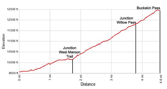
Elevation Profile
Buy the BookThis opinionated guide includes all the hikes in the Aspen, Buena Vista, Crested Butte, Marble and Leadville sections of the website plus info on local services and nearby attractions. | |

Driving Directions
Driving Directions from Aspen:
From Aspen: The Maroon Bells has limited accessibility by car. From June 9th through October 8th the Maroon Creek Road is restricted to vehicles from 8:00 a.m. to 5:00 p.m. beyond the T-Lazy 7 Ranch, unless you have campground reservations or you are overnight backpacking.
A shuttle bus, which leaves every 20 minutes, departs from the Aspen Highlands ski area. There is paid parking at Aspen Highlands or you can take the free Castle Maroon Bus from the Rubey Park Transit Center in downtown Aspen to Aspen Highlands. Dogs are allowed on the bus. Bus tickets that cover the bus and admission to the Maroon Bells Scenic area are sold at Four-Mountain Sports in Aspen Highlands. Check the White River National Forest website for the latest information before setting out on your trip.
Please note the Maroon Bells Scenic Area is a recreation fee area. The Interagency, Senior & Golden Access Passes are honored. Fees apply at all times. Self pay stations are available during off hours.
If you are driving to the Maroon Bells Scenic Area or Aspen Highlands for the shuttle bus from downtown Aspen, follow Hwy 82 heading west to the roundabout just outside of town. Exit the roundabout at the Maroon Creek Road. In approximately one mile reach Aspen Highlands, turn left here for the shuttle.
If arriving during non-bus hours or heading to the backpacker's overnight parking area, continue another 4 miles to the Maroon Bells Scenic Area Welcome Station. The use fee will be collected here, or in the fee tube immediately behind the station if unmanned. Continue another 5 miles to the parking lot at Maroon Lake. Parking is VERY limited in both the day use and overnight lots.
Trail Resources
Trail Intro / Trail Photo Gallery / Trail Map
Basecamp(s) Information:
Aspen
Region Information:
Central Colorado
Other Hiking Regions in:
Colorado