Details: Willow Pass and Lake 
Distance: 9.4 - 12.2 miles (round trip)
Maroon Bells-Snowmass Wilderness, White River National Forest, near Aspen in Central Colorado
Hike Facts
- Distance: 9.4 - 12.2 miles (round trip)
- Elevation: 9,580-ft. - 12,578-ft.
- Elevation Gain: 560-ft. - 3,781-ft.
- Difficulty: strenuous
- Trail Highlights: See Trail Intro
- Basecamp(s): Aspen
- Region: Central Colorado

This lightly traveled trail features great views of the Maroon Bells and Pyramid Peak, traverses pretty meadows and ends at a scenic pass with sweeping views of the colorful cirque surrounding the Willow Lake basin.
Trailhead to Crater Lake/West Maroon Junction
Distance from Trailhead: 3.4 miles (round trip)
Ending/Highest Elevation: 10,140-ft.
Elevation Gain: 560-ft.
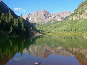
Few hikes can top the stunning views from the start of the Willow Pass trail, beginning at the foot of Maroon Lake. Mirrored in the lake’s waters are the iconic Maroon Bells (14,156-ft. and 14,014-ft.), towering above the head of the valley. Pyramid Peak’s (14,018-ft.) jagged crags rise to the south while the crimson spires of the Sievers Mountains form the backdrop for beautiful aspen groves to the north.
The trail to Willow Pass initially follows the Maroon-Snowmass Trail. The trail starts at a kiosk at the southwest end of the trailhead parking area. If arriving on the shuttle bus, walk down the Maroon Lake Trail to the north shore of Maroon Lake and turn right on the Maroon-Snowmass Trail. The mileage in this description assumes you are starting from the trailhead kiosk.
From the kiosk, follow the Maroon-Snowmass trail along Maroon Lake’s north (right) shore to a junction at the "Deadly Bell's Kiosk" near the head of the lake. Progress will be slow along this section of the trail as the gorgeous scenery invites frequent stops.
At the junction the Scenic Loop Trail branches left. We turn right to stay on the Maroon-Snowmass trail, which ascends a wide rocky path through Aspen and spruce trees along the north side of the valley. Openings in the trees offer views of rugged Pyramid Peak rising to the south.
About a mile from the start the moderately steep trail climbs an ancient rock slide forming a natural dam that created Crater Lake. As you reach the top of the slide enjoy wonderful views of the Maroon Bells and the Sleeping Sexton, located on the ridge extending north from North Maroon Peak.
Junction to Willow Pass
Distance from Trailhead: 9.7 miles (round trip)
Ending/Highest Elevation: 12,578-ft.
Elevation Gain: 2,998-ft.
The Maroon-Snowmass trail ascends steeply through aspen and spruce forest for 0.6 miles to Minnehaha Gulch. Breaks in the trees along the lower section of the climb provide nice views of the Maroon Bells, Crater Lake and the West Maroon Valley. As you gain elevation the trees thin and great views open to the west across Minnehaha Gulch to the Sleeping Sexton and North Maroon Peak.
The initial ascent is along the east side of the gulch, a deep ravine channeling a stream. At 2.9 miles the path rock hops across the stream to the west side of the gulch. Beyond the crossing the trail climbs a hillside through pretty meadows and downed trees, toppled by avalanche activity. The meadows offer wonderful panoramas of North Maroon Peak to the southwest and Pyramid Peak to the southeast.
At the end of the gulch the trail climbs a steep gully beside a small stream festoon with wildflowers and emerges onto a beautiful basin clad in alpine meadows. Buckskin Pass, the saddle looming above the head of the steep valley, is now in sight.
Ascend the meadows on a series of switchbacks with fine views of Maroon Bells and the Sleeping Sexton. Pyramid Peak dominates the skyline to the southeast.
Reach a junction at 3.75 miles. The trail to the left (northwest) leads to Buckskin Pass. We turn right (north) on the trail to Willow Pass and continue the steady climb through pretty meadows. Soon the trail curve around the end of a ridge and then swings to the left (west), climbing steeply up a series of tight switchbacks. Along the way enjoy more great views of the Bells and the Pyramid Peak massif.
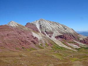
At 4.1 miles the grade abates as the trail crests a rise and enters a pretty basin, surrounded by a colorful cirque anchored by Buckskin Peak (13,370-ft.) to the northwest. The trail to Willow Pass is now in sight, climbing to the saddle on the ridge to the north. Follow the trail as it crosses a small stream and then resumes its ascent on moderately steep grades, heading northwest through meadows.
Arrive at the base of the ridge at 4.5 miles. Here the trail starts a short, extremely steep climb up switchbacks etched into the ridge’s red and gray talus slopes. Great views to the southeast provide a welcome distraction from the stiff climb.
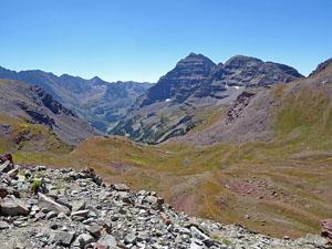
Willow Pass (12,580-ft.) is reached at 4.7 miles. From the pass great views extend north across the rolling alpine meadows of the Willow Lake basin to the rugged ridge running between Buckskin Peak and Peak 13336. Willow Lake (11,795-ft.) and a few smaller ponds lie nestled in a pretty basin beneath the serrated ridge of the Sievers Mountains. To the southeast are more terrific views of the Maroon Bells and Pyramid Peak massif.
Many hikers will turn around at this point and retrace their steps to the trailhead. If the weather is good and time/energy permit, consider extending the hike with a side trip to Willow Lake. This option will add 2.8 miles (round trip) to the hike with an elevation gain/loss of about 790-ft.
From Willow Pass to Willow Lake
Distance from Trailhead: 12.2 miles (round trip)
Ending/Highest Elevation: 11,795-ft.
Elevation Gain: 3,781-ft.
The trail to Willow Lake initially descends steeply through alpine meadows on the north side of Willow Pass before turning right (northeast) and continuing the descent on more moderate grades.
At 5.3 miles the trail curves to the right (east) and the grade abates. To the south are a few small ponds. Pass a junction at 5.5 miles with a faint trail heading northwest toward East Snowmass Pass. Our trail now curves to the right (southeast), traveling through meadows and stunted confers to the north shore of Willow Lake (11,795-ft.) at 6.1 miles. The trail fades as it approaches the lake but the way is obvious.
From the lake enjoy beautiful views of Peak 13336 towering above the valley to the north. The Sievers Mountains fill the skyline to the northeast. The basin is fun to explore. Fishermen will want to try their luck catching some of the lake’s brook trout. Backpackers will find nice campsites in the stunted conifers and rock outcroppings around the lake basin.
Return to the Maroon Lake trailhead when you are done exploring the Willow Lake basin. Alternatively turn the hike into an overnight backpack by spending a night in the lake basin. From Willow Lake hikers with a second car positioned at the East Snowmass trailhead can climb the steep trail to East Snowmass Pass and then descend the East Snowmass Trail to the East Snowmass trailhead, located to the west of Snowmass Village, for a 13.6 mile hike or backpack. Note: The trail climbing to East Snowmass Pass is very steep and travels through a boulder field. Portions of the trail are faint where it crosses the lake basin’s meadows.
Another option is a 3-day loop backpack that starts by hiking up Snowmass Creek to Snowmass Lake. On the second day hike over Buckskin Pass and Willow Pass to Willow Lake. On the final day climb over East Snowmass Pass and drop down the East Snowmass trail to the East Snowmass trailhead. From the trailhead a short walk along a dirt road leads back to the Snowmass Creek trailhead. Note: Bear Canisters are now required for overnight travel in the Maroon Bells Wilderness area. See the Four Pass Loop hike for more information on overnight food storage regulations.
I strongly advise getting an early start when day hiking to Willow Pass and Willow Lake so you can enjoy the pass and the lake before the onset of afternoon thunderstorm, a common occurrence in the Rockies.
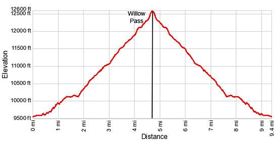
Elevation Profile
Buy the BookThis opinionated guide includes all the hikes in the Aspen, Buena Vista, Crested Butte, Marble and Leadville sections of the website plus info on local services and nearby attractions. | |

Driving Directions
Driving Directions from Aspen:
From Aspen: The Maroon Bells has limited accessibility by car. From June 9th through October 8th the Maroon Creek Road is restricted to vehicles from 8:00 a.m. to 5:00 p.m. beyond the T-Lazy 7 Ranch, unless you have campground reservations or you are overnight backpacking.
A shuttle bus, which leaves every 20 minutes, departs from the Aspen Highlands ski area. There is paid parking at Aspen Highlands or you can take the free Castle Maroon Bus from the Rubey Park Transit Center in downtown Aspen to Aspen Highlands. Dogs are allowed on the bus. Bus tickets that cover the bus and admission to the Maroon Bells Scenic area are sold at Four-Mountain Sports in Aspen Highlands. Check the White River National Forest website for the latest information before setting out on your trip.
Please note the Maroon Bells Scenic Area is a recreation fee area. The Interagency, Senior & Golden Access Passes are honored. Fees apply at all times. Self pay stations are available during off hours.
If you are driving to the Maroon Bells Scenic Area or Aspen Highlands for the shuttle bus from downtown Aspen, follow Hwy 82 heading west to the roundabout just outside of town. Exit the roundabout at the Maroon Creek Road. In approximately one mile reach Aspen Highlands, turn left here for the shuttle.
If arriving during non-bus hours or heading to the backpacker's overnight parking area, continue another 4 miles to the Maroon Bells Scenic Area Welcome Station. The use fee will be collected here, or in the fee tube immediately behind the station if unmanned. Continue another 5 miles to the parking lot at Maroon Lake. Parking is VERY limited in both the day use and overnight lots.
Trail Resources
Trail Intro / Trail Photo Gallery / Trail Map
Basecamp(s) Information:
Aspen
Region Information:
Central Colorado
Other Hiking Regions in:
Colorado