Details: Mount Yale 
Distance: 9.5 miles (round trip)
Collegiate Peaks, San Isabel National Forest, near Buena Vista in Central Colorado
Hike Facts
- Distance: 9.5 miles (round trip)
- Elevation: 9,910-ft. - 14,196-ft.
- Elevation Gain: 4,286-ft.
- Difficulty: strenuous-difficult
- Trail Highlights: See Trail Intro
- Basecamp(s): Buena Vista
- Region: Central Colorado
Get an early start on this very steep climb to the summit of Mount Yale (14,196-ft.). Atop the mountain enjoy great views of nearby 14ers in the Sawatch Range, the Elk Mountains and the Arkansas River Valley.
Trailhead to Mount Yale

The easiest way to reach the summit of Mount Yale is via Denny Creek. (See driving directions below.) From the Denny Creek parking area, the Brown’s Pass/Denny Creek trail heads north, climbing steep switchbacks up an old, rocky road through a forest of lodgepole pines. Soon after passing the boundary of the Collegiate Peaks Wilderness at 0.25 miles the grade ease and the old road curves to the northwest, continuing its ascent on moderate grades through mixed forest along the left (west) side of Denny Creek.
Cross to the right (east) side of Denny Creek on a log bridge at 1.0 mile and then cross a smaller stream a short distance beyond. Openings in the trees offer a brief glimpse of Mount Yale (14,196-ft.) towering above the valley to the northeast.
At 1.3 miles reach the junction with the trail to Mount Yale, branching right. Turn right and follow the Mount Yale trail as it curves to the east/northeast ascending on moderately-steep grades through aspens and pines. At 1.6 miles the trail crosses the shoulder of a ridge separating the Denny Creek Valley from Delaney Gulch.
The trail now climbs northeast through trees up the west side of Delaney Gulch. At 2.25 miles (11,240-ft.) the trail crosses a log bridge over the creek to the east side of the gulch. Beyond the crossing the trail heads north, climbing steeply through forest and meadows along the west facing slopes of Mount Yale.
At 2.5 miles the trail turns southeast and continues its ascent. The path breaks from the trees at 2.9 miles and then travels along a good path through meadows with a few scattered trees. Soon we leave the last of the trees behind. At 3.0 miles the trail reaches a bench where it curves to the left (northeast) and starts the very steep climb up switchbacks through rocky meadows littered with large rocks and bounders. At 3.2 miles the grade briefly eases.
All too soon the stiff climb resumes through rocky meadows. As you climb take time to enjoy fine views of Turner Peak to the west and the summits rising to the south of CR 306, including Mount Princeton. At 3.9 mile pass remnants of the old trail, marked by a “Closed for Restoration” sign. The trail now climbs very steep switchbacks up meadows and talus slopes to the shoulder of the ridge extending northwest from Mount Yale at 4.4 miles.
Turn right (southeast) at the shoulder (13,960-ft.) and follow the trail as it heads toward the summit. The trail is short-lived. Here is where you hit the Class 2 part of the climb. For the last 0.25 miles to the summit follow the rock cairns marking the route along the west side of the rocky ridge. Pay attention and follow the cairns to stay on track. Some relatively easy scrambling is required.
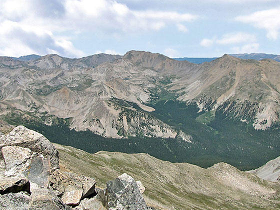
Reach the summit of Mt. Yale (14,196-ft.) at 4.75 miles. From the top enjoy expansive views of the Elk Mountains to the west/southwest. Nearer at hand are the high peaks of the Sawatch Range including Huron Peak, Mt. Belford, Mt. Oxford and La Plata Peak to the north, Mt. Harvard and Mt. Columbia standout to the northeast and Mt. Princeton and Mount Antero to the south. To the east is the Arkansas Valley. Look closely and you will see Ice Pond near Buena Vista.
Retrace your route back to the trailhead when you are done taking in the views.
Note: It is best to get an early start so you are off the peak before the onset of afternoon thunderstorms, a frequent occurrence in the afternoons in the Rocky Mountains.
Preparing to Hike a 14er
Many hikers and climbers come to Buena Vista to summit one of the area’s 14,000-ft. peaks, known as 14ers. There are 58 14ers in Colorado ranging from hiking trails involving a minor amount of scrambling to technical climbing routes requiring ropes and related equipment. The Sawatch Mountains near Buena Vista, with 14 peaks over 14,000-ft., boasts the highest concentration of 14ers in the state.
Novice and casual hikers will be tempted by the challenge of summiting a 14er. It’s a great goal but you need to take the challenge seriously. To summit a 14er you must be in good physical shape and well acclimated. Flatlanders should not plan on arriving in Buena Vista and setting out the next day to summit a peak. The best strategy is to spend a week day hiking the many great trails around Buena Vista, pushing yourself to go higher each day.
Make sure you know the signs of altitude sickness and descend immediately to a lower altitude if symptoms develop. Seek medical help if the symptoms persist at lower altitude.
Get an early start. It is not unusual to see people starting a climb in the wee hours of the morning or at dawn. You will be hiking much slower than you expect. Allocate at least an hour for every 1,000-ft. of elevation gain. Your pace will slow to a crawl once you reach the rarefied air about 12,000-ft. Plan your time accordingly. It is best to be off the summit and below exposed terrain before the early afternoon to avoid thunderstorms, a frequent occurrence in the Rockies during the summer.
Some of the 14ers can be reached by a long day hike. These days will be much harder than you expect. I strongly recommend backpacking to a basecamp and then getting up early the next morning to summit a peak. This will cut down the distance and elevation gain required in a single day. Spending the night at a high altitude will also help you to acclimate.
Check the weather forecast and don’t try to summit if bad weather is imminent. Getting caught in a storm is not fun and can be dangerous. Make sure you take plenty of warm clothing, including a hat and gloves. Rain gear including pants is a must. A map, compass and safety equipment, such as matches, a first aid kit, knife and headlamp, are strongly recommended. The Gear list on the 14ers.com website includes an excellent packing list.
Be sure to take plenty of food and water to maintain your energy level and stay hydrated. Carry two to three quarts of water per person, tons of energy bars or other sources of protein and a substantial lunch.
Pick a 14er that matches your experience level. Plan the route and know what to expect. Read trip reports to learn about the terrain. The 14ers.com website includes an amazing trove of great information on climbing Colorado’s 14,000-ft. peaks. Before your trip leave an itinerary with friend or a relative.
Once you set out, don’t be afraid to turn around if in doubt. It always disappointing to turn around but if the weather is threatening, the trail is covered in slick snow/ice, you’re feeling unwell or you’re just uncomfortable on the trail, it is the right decision. Be smart, the mountain will be there for another attempt at some later date.
Here are descriptions of some of the easier 14,000-ft. summits in the area. Other peaks to consider include Mt. Elbert and Mt. Princeton.
Note: All the hikes listed below are rated as Class 2 climbs. Grades are assigned to climbs based on their difficulty. A Class 1 climb is really just a hike. A Class 2 climb is a more difficult hike up steep slopes, over boulder fields and/or ascending loose scree slopes. The route may involve some scrambling, with the possible use of the hands. There may be some exposure along the route.
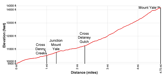
Elevation Profile
Buy the BookThis opinionated guide includes all the hikes in the Aspen, Buena Vista, Crested Butte, Marble and Leadville sections of the website plus info on local services and nearby attractions. | |

Driving Directions
Driving Directions from Buena Vista: From the traffic light at the intersection of U.S.24 and Country Road 306 in downtown Buena Vista, drive west on CR 306 for 12 miles and turn right (north) into the paved Denny Creek Trailhead parking area. The parking area is about a mile beyond the Collegiate Peaks Campground (located along the left side of CR 306). There is additional parking in a gravel lot just to the east.
Note: This is a very popular trailhead, providing access to Hartenstein Lake, Mount Yale and Brown’s Pass. The parking area fills early during the height of the summer hiking season.
Trail Resources
Trail Intro / Trail Photo Gallery / Trail Map
Basecamp(s) Information:
Buena Vista
Region Information:
Central Colorado
Other Hiking Regions in:
Colorado