Details: Beckwith Pass via Cliff Creek 
Distance: 4.7 - 9.4 miles (round trip)
West Elk Wilderness, Gunnison National Forest, near Crested Butte in Central Colorado
Hike Facts
- Distance: 4.7 - 9.4 miles (round trip)
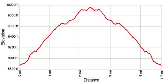
- Elevation: 8,860-ft. - 9,954-ft.
- Elevation Gain: 1,094-ft.
- Difficulty: moderate
- Trail Highlights: See Trail Intro
- Basecamp(s): Crested Butte
- Region: Central Colorado
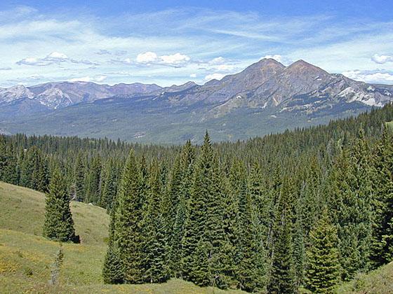
This short hike features fine views of the Ruby Range, the Raggeds and East Beckwith Mountain. Extend the hike by walking to a high point with panoramic vistas of the West Elk Wilderness or continue to Beckwith Bench where the Anthracite Range joins the scene.
Trailhead to Beckwith Pass
There are two ways to get to Beckwith Pass, the Beckwith Pass trail #842 that begins at Lost Lake Slough and the Cliff Creek Trail #840, which starts just beyond Horse Ranch Park on the Kebler Pass Road. The Cliff Creek Trail involves more elevation gain but requires less driving and has the better views. Both are nice hikes. The description below is for the Cliff Creek trail to Beckwith Pass.
The Cliff Creek trail is located at the southeast end of the parking area. (See driving directions.) Follow the trail as it heads southwest on easy grades through aspen. Soon the trail climbs a steep hillside to a crossing of Cliff Creek at 0.6 miles. Beyond the creek the trail ascends on moderate grades through spruce/fir forest and meadows. From the meadows enjoy ever-improving views of Ruby Peak (12,644-ft.) and Mount Owen (13,058-ft.) in the Ruby Range to the northeast. As you climb the views expand to include the peaks and ridges to the north of Mount Owen.
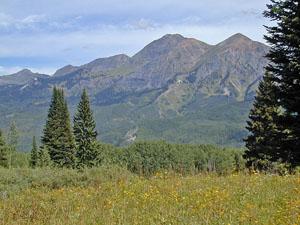
At 1.5 miles the grade abates. Soon views open to East Beckwith Mountain (12,432-ft.) rising to the west. At 1.8 miles the trail enters dense forest and reaches the junction with the Beckwith Pass trail. (Turning right at the junction will take you to Lost Lake Slough.) Continue straight ahead on the Cliff Creek trail, which crosses the creek and then climbs steeply through trees. At 2.0 miles the trail curves to the left (southeast). Soon the grade abates and the trees give way to pretty wildflower-filled meadows. The pass is now in sight.
Reach Beckwith Pass (9,954-ft.) at 2.35 miles. Here you will find a sign marking the beginning of the West Elk Wilderness and a gate. Past the gate is a signed trail junction. From the pass the Ruby Range, Ragged Mountains and Marcellina Mountain (11,348-ft.) fill the skyline to the north. East Beckwith Mountain dominates the view to the west. Storm Ridge rises to the south. The interesting rock formation to the left (east) beyond Storm Ridge is the Castles, formed from dark volcanic breccia rock that eroded into spires, towers and stone walls.
At the trail junction a sign points left for the trail heading toward Swampy Pass and right for the trail to Beckwith Bench. Ignore the two minor trails that travel along the fence line. If you have the time and energy you can continue 0.9 miles beyond the pass, ascending through beautiful meadows along the Beckwith Bench trail to a high point with panoramic views of the West Elks and the peaks to the north.
Beyond the high point the trail drops down through aspens to a swampy area. Just before you hit a group of small ponds an unmarked trail turns right (west). (If you reach the ponds turnaround and ascend along the trail until you see the path.) This trail climbs through rock slides and aspen groves to emerge at Beckwith Bench, a huge meadow on a shelf below the south face of East Beckwith Mountain, at 4.7 miles. From the bench enjoy grand views of the Anthracite Range to the east and the peaks of the West Elk Wilderness to the south.
Elevation Profile
Buy the BookThis opinionated guide includes all the hikes in the Aspen, Buena Vista, Crested Butte, Marble and Leadville sections of the website plus info on local services and nearby attractions. | |

Driving Directions
Driving Directions from Crested Butte: From the intersection of Elk Avenue (main street) and 6th Street in Crested Butte, head south on 6th Street for 0.1 miles and turn right on Whiterock Ave. Follow the road through downtown Crested Butte. At the west end of town Whiterock Ave becomes the Kebler Pass Road (CO 12). Follow Whiterock/Kebler Pass road for 12.1 miles and turn left at the signed Cliff Creek trailhead. Follow the dirt access road for 0.2 miles to the trailhead parking area.
Trail Resources
Trail Intro / Trail Photo Gallery / Trail Map
Basecamp(s) Information:
Crested Butte
Region Information:
Central Colorado
Other Hiking Regions in:
Colorado