Details: Frigid Air and Hasley Pass 
Distance: 9.6 miles (loop)
Maroon Bells-Snowmass Wilderness, White River National Forest, near Crested Butte in Central Colorado
Hike Facts
- Distance: 9.6 miles (loop)
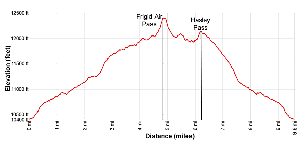
- Elevation: 10,420-ft. - 12,415-ft.
- Elevation Gain: 1,995-ft. - 2,095-ft.
- Difficulty: strenuous
- Trail Highlights: See Trail Intro
- Basecamp(s): Crested Butte
- Region: Central Colorado
This great loop hike travels up wildflower-filled meadows to two scenic passes with stunning views of the high peaks of the Elk Mountains including the Maroon Bells, Snowmass Mountain and Hagerman Peak. Route finding and off-trail travel is required to complete the loop.
Trailhead to Frigid Air Pass
Distance from Trailhead: 9.6 miles (round trip)
Ending/Highest Elevation: 12,415-ft.
Elevation Gain: 1,995-ft.
Note: The hike to Frigid Air Pass is along a good, established trail that any hiker should be able to follow. Beyond Frigid Air the hike requires route finding skills.
I am somewhat reluctant to describe hikes that require off-trail travel and route finding skills for fear that hikers who don’t know what they are doing will get lost. Don’t attempt the route portion of this hike unless you are experienced with route finding and have a good map of the area. A compass and/or GPS are also extremely helpful when traveling off trail and along routes where use trails fade and, at times, disappear.
Finally, it is always good idea to turn around and look back at the way you have walked. In the event of trouble this will help you to find your way back to the last well marked trail.
The trail to Frigid Air pass starts at the East Fork trailhead. (See driving directions.) Follow the trail as it heads east through spruce trees along the north side of the East Fork of the Crystal River. Soon the trail curves to the left (northeast) and leaves the river behind as it climbs switchbacks on moderate grades. The trees thin as the trail reaches an old mining cabin at 0.3 miles. A short distance beyond a sign marks the boundary for the Maroon Bells-Snowmass Wilderness.
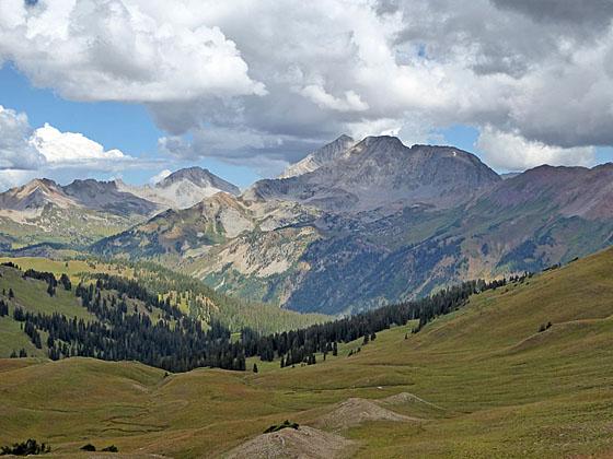
At 0.4 miles the grade abates as the trail curves to the right (east) and begins an ascending traverse through meadows along the northeast side of the East Fork valley, high above the river. Views open to Mt. Bellview (12,519-ft.) to the southeast, Mount Baldy (12,805-ft.) and Cinnamon Mountain (12,933-ft.) to the southwest and Galena Mountain (12,580-ft.) to the west. Closer at hand, the meadows along the trail sport a spectacular display of wildflowers during late July and early August.
As you progress up the valley the trail crosses a few streams that are typically dry. At 1.2 miles the path crests a small rises and then descends briefly. At the bottom of the descent a faint, unmarked trail branches to the right (south). This trail eventually leads to Schofield Pass. We continue straight ahead, ascending the valley on moderate grades.
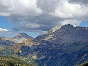
As you climb enjoy ever improving views of the peaks and ridges defining the head of the valley. Behind you, to the west/southwest, are fine views of Mt. Baldy, Cinnamon Mountain, Galena Mountain, Treasure Mountain and, in the distance, Purple Mountain and the summits of the Ruby Range.
Reach a “Y” intersection at 2.0 miles. We bear right on the trail signed for West Maroon Pass. The unmarked trail to the left (northwest) climbs to Hasley Pass, the return leg of the loop. Beyond the junction the trail climbs briefly and then curves to the right (east), contouring through lush meadows and clusters of low willows. Along the way cross a stream which is typically dry after the snow melts.
At 2.4 miles start a steep ascent through meadows and willow patches. As you climb the trail curves to the southwest. To the west are great views of Galena and Treasure Mountains.
The grade eases at 2.9 miles and now ascends on moderate grades, reaching a signed trail junction at 3.1 miles. Here the trail to West Maroon Pass continues straight ahead (southeast). We turn left (northwest) on the trail to Frigid Air Pass.
Follow the undulating trails as it ascends northwest through lovely meadows. To the west/southwest are gorgeous views of Galena Mountain, Treasure Mountain, Mount Baldy, Cinnamon Mountain and, in the distance, Purple Mountain and the other peaks of the Ruby Range. Peak 12648, a red, pyramid-shaped mountain, towers above the valley to the northwest.
Reach a junction near a small pond beneath Peak 12648 at 4.5 miles. Turn right (north) on the signed trail to Frigid Air Pass. The unsigned trail to the left (west) leads to Hasley Basin. The trail to the pass skirts the left (west) side of the pond and climbs very steep switchbacks to Frigid Air Pass (12,415-ft.) at 4.8 miles, gaining 365-ft in 0.3 miles. Trekking poles are extremely help, especially when descending this section of the trail.
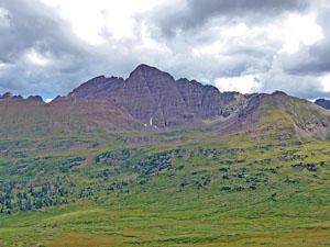
As you crest the pass stunning views open to the Maroon Bells towering above the emerald green meadows of the Fravert Basin. The white granite of Snowmass Mountain (14,092-ft.) and Hagerman Peak (13,841-ft.), dominating the view to the northwest, stands in sharp contrast to the crimson-brown mudstone of the Maroon Bells massif. Bellview Mountain (13,233-ft.) rises along the ridge at the head of Fravert Basin. Behind you, to the west/southwest, Mt Baldy, Treasure Mountain and Purple Mountain fill the skyline.
Find a perch atop the pass to rest and take in the views. Expect to see plenty of backpackers at the pass or heading toward the pass in both directions. Backpackers cross Frigid Air Pass as part of the popular 26.6-mile Four Pass Loop, a 3-5 day backpacking trip climbing four 12,000-ft.-plus mountain passes in the Maroon-Snowmass Wilderness.
When you are done enjoying the views, descend from the pass to the junction and turn right (west) on the unmarked trail toward Hasley Basin. Follow the narrow, faint trail as it ascends on easy grades to a saddle at 5.5 miles, which I call the Hasley Basin Overlook (12,085-ft.), situated on the ridge between Peak 12648 and Peak 12345 to the west.
From the saddle enjoy terrific views of Snowmass Mountain, Hagerman Peak and the summits rising above the Geneva Lake basin to the north. Below you to the north/northwest are the beautiful meadows of Hasley Basin. Note the interesting stripped rock formation on the ridge along the west side of the basin.
Behind you, to the east, Belleview Mountain (13,233-ft.) towers above West Maroon Pass (12,500-ft.). To the northeast is Frigid Air Pass, where you will probably see hikers silhouetted against the skyline.
You now have several options, retrace your steps to the trailhead or follow one of two routes back to the unsigned junction along the East Fork trail passed on the trip up valley. Note: Both options require route finding skills. Use trails along sections of both routes fade and disappear at times. There are also numerous cow tracks to further complicate route finding. Make sure you have a good map and understand the route before you try one of these options.
Option 1: Hasley Pass Loop
Distance from Trailhead: 9.6 miles (loop)
Ending/Highest Elevation: 12,150-ft.
Elevation Gain: 2,095-ft.
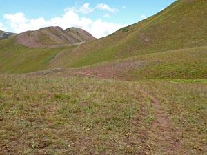
This is the longer of the two routes, crossing the head of Hasley Basin to Hasley Pass and then dropping down to the East Fork trail. Looking left (west) while standing at the overlook you will see a ridge extending north into Hasley Basin. The upper sections of the ridge are covered in talus that give way to meadows and stunted trees.
From the overlook, head left (west) across the head of Hasley Basin through alpine meadows. Aim to cross the ridge extending into the basin by climbing up the meadows slightly below the point where the talus ends. (Approximate GPS Coordinate: 39.051768, -107.035109 .) Pass through the vegetation atop the ridge and then look southwest at the talus slopes along the west side of the ridge. Here you should see a faint trail crossing the talus that eventually meets a trail coming up the valley. Follow the faint trail across the talus to the trail coming up the valley. Beyond the junction, the combined trails heads south, climbing steeply to the ridge at the head of the valley.
As the trail crests the ridge it curves to the right and descends along the top of the ridge to Hasley Pass (12,110-ft.) at 6.3 miles. Take a break here to enjoy the panoramic views that stretch from Snowmass Mountain and Hagerman Peak to north to the peaks along the Ruby Range to the south. Belleview Mountain and West Maroon Pass dominate the view to the southeast.
When you are done taking in the views head down the southeast side of Hasley Pass on a trail that soon curves to the southeast, descending through meadows on moderate to moderately steep grades. As the trail reaches a few scatter trees it starts curving to the east, reaching a junction at 7.1 miles. Turn right (southeast) at the junction and follow the trail as it drops down to and crosses a creek. Beyond the crossing the trail descends steep switchbacks to the junction with the East Fork trail at 7.6 miles. Turn right at the junction and follow the East Fork trail back to the trailhead for a 9.6 mile hike.
Note: The trail descending from Hasley Pass to the East Fork is unmaintained and may be faint in places and difficult to follow.
Option 2: Hasley Overlook Loop
Distance from Trailhead: 8.8 miles (loop)
Ending/Highest Elevation: 12,110-ft.
Elevation Gain: 2,030-ft.
The shortest route from the Hasley Overlook back to the East Fork trail follows a use trail on the southeast side of the overlook that descends southwest and then south on easy grades. At times the route fades and is difficult to follow. At 5.7 miles reach the crest of the ridge extend east into the East Fork valley. You should reach the ridge near a copse of trees. Here you will lose the trail.
Below the south side of the ridge is a steep, grassy hillside. If you are lucky you will see a faint trail making a wide arc as it descends the hillside on very steep grades to a narrow bench. If you can’t find the trail simply drop down to the bench.
Upon reaching the bench, continue the steep descent by heading southeast along the bench. You may pick-up vestiges of a trail along the way. As you descend the trail curves to the south at 6.0 miles and then turns southwest, dropping down to and crossing a creek. It is very difficult to follow the faint trail. If you get off the trail or can’t find it, descend steeply along the bench and then curve to the south/southwest, staying to the north of a cluster of trees growing amid rock outcroppings. The goal is to cross the creek before you hit a deep gully. Descend along the west side of the creek until you hit the trail descending southeast toward the valley floor.
For hikers who have found the trail, on the west side of the creek the trail heads south and reaches a junction at 6.25 miles. Ignore the trail to the left (southwest), instead continue straight ahead following the trail as it curves to the southeast along the west side of the creek. Soon the path crosses the creek and drops down steep switchbacks to the junction with the East Fork trail at 6.75 miles. Turn right at the junction and follow the East Fork trail back to the trailhead for an 8.8 mile round-trip hike.
Elevation Profile
Buy the BookThis opinionated guide includes all the hikes in the Aspen, Buena Vista, Crested Butte, Marble and Leadville sections of the website plus info on local services and nearby attractions. | |

Driving Directions
Driving Directions from Crested Butte: From the intersection of Elk Avenue (main street) and 6th Street in Crested Butte, head north on 6th Street, which turns into the Gothic Road (sometimes referred to as the Schofield Pass Road). Follow the Gothic Road (CO 317) for 13.2 miles to Schofield Pass, passing the ski area and the research facilities at Gothic along the way. The dirt road is suitable for 2WD cars up to the town of Gothic at 7.9 miles. Beyond Gothic the road become rougher and a high clearance/4WD vehicle is required.
Continue over Schofield pass, descending the north side of the pass on switchbacks and then through meadows for 0.8 miles and turn right (east) at the signed East Fork trailhead. The turn is right before you hit Schofield Park, a large open park at the foot of the switchbacks. As you enter the trailhead, bear right into the parking area. The road branching to the left is for horse trailers.
Trail Resources
Trail Intro / Trail Photo Gallery / Trail Map
Basecamp(s) Information:
Crested Butte
Region Information:
Central Colorado
Other Hiking Regions in:
Colorado