Details: Rustler Gulch 
Distance: 6.4 - 10.0 miles (round trip)
Maroon Bells-Snowmass, Gunnison, near Crested Butte in Central Colorado
Hike Facts
- Distance: 6.4 - 10.0 miles (round trip)
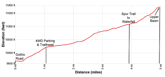
- Elevation: 10,240-ft. - 11,740-ft.
- Elevation Gain: 860-ft. - 1,500-ft.
- Difficulty: moderate
- Trail Highlights: See Trail Intro
- Basecamp(s): Crested Butte
- Region: Central Colorado
Hike through beautiful meadows to a lovely waterfall and high alpine basin beneath Precarious and Cassi Peaks. From mid-July to early August the meadows of Rustler Gulch host spectacular wildflowers displays.
Trailhead to the Waterfall

Distance from Trailhead: 6.4 miles (round trip)
Ending/Highest Elevation: 11,100-ft.
Elevation Gain: 860-ft.
From the 2WD Parking Area
Distance from Trailhead: 8.6 miles (round trip)
Trailhead: 9,680-ft.
Ending/Highest Elevation: 11,100-ft.
Elevation Gain: 1,420-ft.
Note: This description assumes you walk the 4WD Rustler Gulch Road to the trailhead (see driving directions below). Subtract 1.1 mile and 560-ft. in elevation gain if you drive to the 4WD parking area, the official start of the trail.
From the Gothic Road, walk east on the Rustler Gulch 4WD Road for 800-ft. to a broad crossing of the East River. If you prefer not to wade the river bear left on a trail that climbs steeply over a low hill to a point where the river flows into a shallow pond. A route using logs and willow debris creates a crossing that will keep your feet dry. Once across the river follow a use trail that reconnects with the road.
Beyond the river ascend the dirt road on moderate to moderately-steep grades. At 0.4 miles the #401 Trail, a popular mountain biking path, branches left. We continue up the road to a metal gate marking the start of the Rustler Gulch Trail (#599) at 1.1 miles. Along the way views of Mt Avery (12,653-ft.) fill the skyline to the southeast, Mount Baldy (12,805-ft.) rises to the west while Gothic Mountain (12,625-ft.) dominates the view behind you to the south. Note: Right before the gate a road branches to the left, this is the Bellview Trail.
Just beyond the gate pass a sign marking the boundary of the Maroon Bells-Snowmass Wilderness. The Rustler Gulch trail, once an old mining road, ascends on easy grades through wildflower–filled meadows and spruce-fir forest along the west side of Rustler Creek. As you climb, enjoy ever-improving views of Mt. Bellview (12,519-ft.) rising above the west side of the valley.
A 1.75 miles the trail crosses a creek. Logs and rocks will help keep your feet dry. At 2.0 miles the trail crosses to the east side of Rustler Creek. Again logs and rocks will help keep your feet dry except during high water.
Beyond the creek crossing the trail ascends on easy to moderate grades through pretty meadows with lovely views of Mount Bellview and the unnamed peaks rimming the west side of the valley. At 2.3 miles the trail crosses back to the west side of Rustler Creek. This section of the creek is quite pretty with small cascade tumbling down rock ledges.
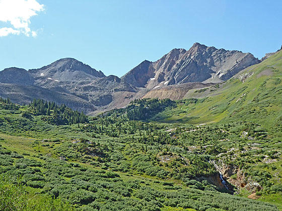
Past the crossing the trail quickly crosses a tributary creek and then climbs on moderately-steep grades through meadows with scattered trees. At 2.7 miles the grade abates as the trail curves to the northeast, crosses an avalanche chute and then swings east as it travels through wildflower-filled meadows toward the head of the valley. Here views open to Peak 13,163-ft. and Precarious Peak (13,380-ft.) towering above the head of the valley. Soon Cassi Peak (13,232-ft.) and Peak 13,210-ft. join the scene. Turn around for lovely views down valley.
At 3.9 miles an old road branches right, dropping down to the creek near a pretty waterfall. For many parties the waterfall at 4.2 miles is the destination for their hike and a good turnaround point.
Waterfall to the Upper Basin

Distance from Trailhead: 7.8 miles (round trip)
Ending/Highest Elevation: 11,740-ft.
Elevation Gain: 1,500-ft.
From the 2WD Parking Area
Distance from Trailhead: 10.0 miles (round trip)
Trailhead: 9,680-ft.
Ending/Highest Elevation: 11,740-ft.
Elevation Gain: 2,060-ft.
If time and energy allow, I recommend staying on the main trail and continuing up the valley. Along the way enjoy great views of the falls.
The trail now curves to the right (southeast), echoing the contour of the valley, as it ascends on moderate to moderately steep grades through meadows with scattered thickets of willows. At 4.4 miles the trail enters a cluster of scattered trees, passing a ruin and some mining equipment. Cross the creek again at 4.6 miles. The trail, which is now just a boot beaten path, winds through a pretty meadow and then curves around to reach the creek, at 4.7 miles. Here the trail ends.
Continuing a little further up the valley is not difficult. Simply plot a course through the meadows to the south and then west of the creek. Ahead massive talus slopes spill down the slopes of Precarious and Cassi Peaks. Soon you will see a trail climbing up the lowest slope. It dead-ends near a cluster of stunted conifers in the upper basin. The high peaks of the cirque loom overhead. To the northwest is the top of a knoll, clad in meadows littered with rock outcroppings, stunted evergreens and a small tarn. Gorgeous views stretch northwest to the high peaks ringing the north side of the valley. The top of Bellview Mountain (13,233-ft.), located near West Maroon Pass, is seen above the ridge.
After taking a break, turn around and retrace your steps to the trailhead.
Elevation Profile
Buy the BookThis opinionated guide includes all the hikes in the Aspen, Buena Vista, Crested Butte, Marble and Leadville sections of the website plus info on local services and nearby attractions. | |

Driving Directions
From Crested Butte: From the intersection of Elk Avenue (main street) and 6th Street in Crested Butte, head north on 6th Street, which turns into the Gothic Road (sometimes referred to as the Schofield Pass Road). Follow the Gothic Road (CO 317) for 10.5 miles and turn right (east) at the Rustler Gulch trailhead. Follow the access road for 0.1 miles to the East River. If driving a passenger car or if the water is high, park along the Gothic Road or travel 500-ft. up the access road to a small parking lot on the left (north) side of the road. Otherwise, cross the river and follow the moderately-steep access road for a mile. Right before the trailhead there are pull-offs along the side of the road with space for 5-6 vehicles. The road is very slippery when wet. Warning: Use extreme caution when crossing the river. The water can be very deep. A sign warns of cars totaled trying to cross the river. When in doubt park on the east side of the river and walk.
Trail Resources
Trail Intro / Trail Photo Gallery / Trail Map
Basecamp(s) Information:
Crested Butte
Region Information:
Central Colorado
Other Hiking Regions in:
Colorado