Details: West Maroon Pass from Crested Butte 
Distance: 7.8 miles (round trip)
Maroon Bells-Snowmass Wilderness, White River National Forest, near Crested Butte in Central Colorado
Hike Facts
- Distance: 7.8 miles (round trip)
- Elevation: 10,420-ft. - 12,500-ft.
- Elevation Gain: 2,080-ft.
- Difficulty: moderate-strenuous
- Trail Highlights: See Trail Intro
- Basecamp(s): Crested Butte
- Region: Central Colorado
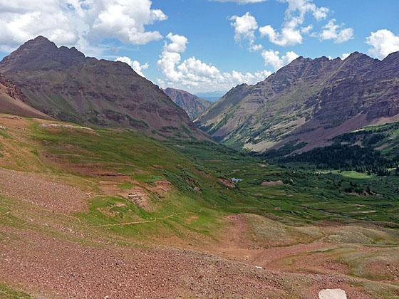
Starting in Schofield Park near Crested Butte, this lovely hike ascends through the wildflower-filled meadows of the East Fork Valley to West Maroon Pass. From the pass enjoy grand views of the Maroon Bells, Pyramid Peak and Treasure Mountain massifs.
Trail head to West Maroon Pass
The trail to West Maroon Pass starts at the East Fork trailhead. (See driving directionns.) Follow the trail as it heads east through spruce trees along the north side of the East Fork of the Crystal River. Soon the trail curves to the left (northeast) and leaves the river behind as it climbs switchbacks on moderate grades. The trees thin as the trail reaches an old mining cabin at 0.3 miles. A short distance beyond a sign marks the boundary for the Maroon Bells-Snowmass Wilderness.
At 0.4 miles the grade abates as the trail curves to the right (east) and begins an ascending traverse through meadows along the northeast side of the East Fork valley, high above the river. Views open to Mt. Bellview (12,519-ft.) to the southeast, Mount Baldy (12,805-ft.) and Cinnamon Mountain (12,933-ft.) to the southwest and Galena Mountain (12,580-ft.) to the west. Closer at hand, the meadows along the trail sport a spectacular display of wildflowers during late July and early August.
As you progress up the valley the trail crosses a few streams that are typically dry. At 1.2 miles the path crests a small rises and then descends briefly. At the bottom of the descent a faint, unmarked trail branches to the right (south). This trail eventually leads to Schofield Pass. We continue straight ahead, ascending the valley on moderate grades.
As you climb enjoy ever improving views of the peaks and ridges defining the head of the valley. Behind you, to the west/southwest, are fine views of Mt. Baldy, Cinnamon Mountain, Galena Mountain, Treasure Mountain and, in the distance, Purple Mountain and the summits of the Ruby Range.
Reach a “Y” intersection at 2.0 miles. We bear right on the trail signed for West Maroon Pass. The unmarked trail to the left (northwest) climbs to Hasley Pass. Beyond the junction the trail climbs briefly and then curves to the right (east), contouring through lush meadows and clusters of low willows. Along the way cross a stream which is typically dry after the snow melts.
At 2.4 miles start a steep ascent through meadows and willow patches. As you climb the trail curves to the southwest. To the west are great views of Galena and Treasure Mountains.
The grade eases at 2.9 miles and now ascends on moderate grades, reaching a signed trail junction at 3.1 miles. Here the trail to Frigid Air Pass branches to the left (northwest). We continue straight ahead (southeast/east) toward Maroon Pass on a steep trail climbing through pretty meadows sprinkled with wildflowers.
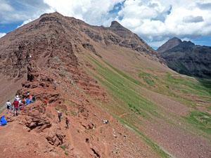
At 3.75 miles the meadows give way to scree covered slopes. A few switchbacks help ease the final steep haul to West Maroon Pass (12,500-ft.) at 3.9 miles. From the pass views extend west to the Treasure Mountain massif. Below are the vast meadows of Purity Basin at the head of the East Fork valley. To the northeast the Maroon Bells and Pyramid Peak massifs fill the skyline above the West Maroon valley. Belleview Mountain (13,233-ft.) rises along the rugged ridge extending northwest from the pass.
The pass is the turnaround point for most day hikers. Backpackers cross the pass as part of the popular 26.6-mile Four Pass Loop, a 3-5 day backpacking trip climbing four 12,000-ft. passes in the Maroon Bells-Snowmass Wilderness.
There are several options for the return leg of the hike. The easiest is to turnaround and retrace your steps for a 7.8 mile round trip (RT) hike. If time, energy and the weather permit, a side trip to Frigid Air Pass is a great option. Extending the hike to Frigid Air will add 3.3 miles to the hike for a 11.1 mile RT hike with an additional gain of about 700-ft. (See the Frigid Air Pass hiking description for more information.)
With proper planning it is possible to cross West Maroon Pass on a day hike and end up at the Maroon Lake trailhead, with bus service to nearby Aspen Highland and Aspen. You will need to spot a car at Aspen Highlands parking area near Aspen or arrange a ride (Dolly's Mountain Shuttle: (970) 349-2620).
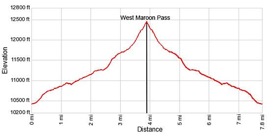
Elevation Profile
Buy the BookThis opinionated guide includes all the hikes in the Aspen, Buena Vista, Crested Butte, Marble and Leadville sections of the website plus info on local services and nearby attractions. | |

Driving Directions
Driving Directions from Crested Butte: From the intersection of Elk Avenue (main street) and 6th Street in Crested Butte, head north on 6th Street, which turns into the Gothic Road (sometimes referred to as the Schofield Pass Road). Follow the Gothic Road (CO 317) for 13.2 miles to Schofield Pass, passing the ski area and the research facilities at Gothic along the way. The dirt road is suitable for 2WD cars up to the town of Gothic at 7.9 miles. Beyond Gothic the road become rougher and a high clearance/4WD vehicle is required.
Continue over Schofield Pass, descending the north side of the pass on switchbacks and then through meadows for 0.8 miles and turn right (east) into the signed East Fork trailhead. The turn is right before you hit Schofield Park, a large open park at the foot of the switchbacks. As you enter the trailhead, bear right into the parking area. The road branching to the left is for horse trailers.
Trail Resources
Trail Intro / Trail Photo Gallery / Trail Map
Basecamp(s) Information:
Crested Butte
Region Information:
Central Colorado
Other Hiking Regions in:
Colorado