Details: Yule Pass 
Distance: 4.9 miles (round trip)
Gunnison National Forest, near Crested Butte in Central Colorado
Hike Facts
- Distance: 4.9 miles (round trip)
- Elevation: 11,250-ft. - 11,715-ft.
- Elevation Gain: 465-ft.
- Difficulty: moderate
- Trail Highlights: See Trail Intro
- Basecamp(s): Crested Butte
- Region: Central Colorado
Panoramic views accompany every step of this great, easy hike along an old mining road to Yule Pass, where sweeping views extend to the peaks rising beyond Yule Creek, Purple Canyon and the Upper Slater River Valleys. Nearer at hand Purple and Treasure Mountains tower overhead.
Trailhead to Yule Pass
WARNING: This trail is no longer recommended due to its deteriorated condition which poses a high risk for hikers. Rock slides and avalanches have obliterated sections of the road/trail which are now spanned by narrow, boot beaten trails with unstable footing and a lot of exposure. Check on current conditions at the Crested Butte Visitor Center. A better option is to pick another trail.
The mileage for this hike assumes you park near Paradise Divide. If you park near the Yule Pass trailhead subtract 0.15 miles from the directions below. (See driving directions for more information.)
Note: Don’t attempt this trail if snow is present. Steep snowfields along the trail are extremely dangerous and should not be crossed except by experienced parties equipped with ice axes and crampons. It is best not to try this hike until the end of July. Check with the Crested Butte Visitor Center for current road and trail conditions.
From Paradise Divide head north/northwest up the Yule Pass road, marked with a sign. At 0.15 miles the trail curves to the left, skirts the north side of a small pond and passes a trailhead sign.
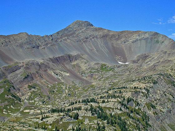
Soon the old wagon road curves to the left (west) and ascends on easy grades along the southern flanks of Cinnamon Mountain (12,293-ft.), crossing rock slides/avalanche chutes along the way. Views open across the valley to a waterfall tumbling down a rocky cleft along the Purple Canyon wall and into the nascent Slate River. Turn around for nice views down the Slate River Valley.
At 0.5 miles the trail curves to the right (northwest) around Cinnamon Mountain’s southwest ridge and continues its ascent along the old road, etched into valley’s steep talus slopes high above the river. Treasure Mountain (13,462-ft.) dominates the view to the northwest while Purple Mountain (12,958-ft.) fills the skyline to the west. Yule Pass, the saddle on the ridge between the two peaks, is visible at the head of the valley.
After walking a little over a mile the trail curves to the left (west/southwest) and crosses two gullies along the flanks of Treasure Mountain’s southeast ridge. Rock slide have obliterated sections of the road which are now spanned by narrow, boot beaten trails. As you progress up the valley long sections of the road are now just a trail. Sections of the path are quite narrow with some exposure and not recommended for people with a fear of heights or uncomfortable with steep drop-offs.
Soon the trail curves to the right (west/northwest) and continues its easy ascending traverse along the flanks of Treasure Mountain’s southeastern ridge. This segment of the trail enjoys terrific views of Purple Mountain. Turn around for fine views down the length of Purple Canyon to the Slate River Valley.
At 1.8 miles a stream cascades down the rugged flanks of the ridge and spills across the trail. A short distance beyond the trail travels through a rock slide and crosses some seeps and another stream tumbling down a gully carved into the steep slopes above the trail.
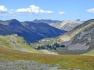
Follow the trail as it curves to the left (southwest) at 2.3 miles and climbs to Yule Pass (11,715-ft.) at 2.5 miles. As you crest the pass the Yule Creek Valley springs into views. Mount Justice (11,730-ft.) and Marble Peak (11,314-ft.) rise to the west/northwest with Chair Peak (12,721-ft.) and Ragged Peak (12,094-ft.) in the distance. To the east great views extend down the length of Purple Canyon to Cinnamon Peak, Gothic Mountain (12,625-ft.) and Mount Crested Butte (12,162-ft.).
On the west side of the pass are three trails. The center trail drops down the Yule Creek Valley to the Yule Creek trailhead near Marble, CO in 5.6 miles. A trail to the left leads to a class 3 route climbing to the summit of Purple Mountain while the trail to the right heads toward the summit of Treasure Mountain, another class 3 ascent.
After taking in the views retrace your steps to the trailhead, enjoying the great views of Purple Canyon and the Slate River valley along the way.
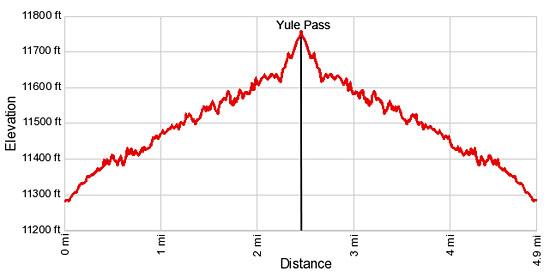
Elevation Profile
Buy the BookThis opinionated guide includes all the hikes in the Aspen, Buena Vista, Crested Butte, Marble and Leadville sections of the website plus info on local services and nearby attractions. | |

Driving Directions
Driving Directions from Crested Butte (Option 1): From the intersection of Elk Avenue (main street) and 6th Street in Crested Butte, head north on 6th Street, which turns into the Gothic Road. Follow the Gothic Road (CO 317) for 0.9 miles and turn left (northwest) onto the Slate River Road (CR 734). Follow CR 734 for 11.9 miles to Paradise Divide, adjacent to a large pond and marked with a sign. The route will go through the summer cabins at Pittsburg and then climbs steep switchbacks with steep drop-offs. Turn left at Paradise Divide and find a good place to park off the road and out of traffic.
It is possible to drive up the Yule Pass road (the first right turn) for 0.15 miles. A limited number of parking places are located along the side of the road. Make sure you do not block the road. My advice is to park near Paradise Divide and walk up the road.
Note: CR 734 is paved for the first 3.6 miles and then turns into a dirt road, which is OK for 2WD cars with reasonable clearance under good conditions. Check at the Crested Butte Visitor Center for current road condition.
Driving Directions from Crested Butte (Option 2): From the intersection of Elk Avenue (main street) and 6th Street in Crested Butte, head north on 6th Street, which turns into the Gothic Road (sometimes referred to as the Schofield Pass Road). Follow the Gothic Road (CO 317) for 13.2 miles to Schofield Pass, passing the ski area and the research facilities at Gothic along the way. The dirt road is suitable for 2WD cars up to the town of Gothic at 7.9 miles. Beyond Gothic the road become rougher and a high clearance/4WD vehicle is required.
Just beyond Schofield Pass turn left on CR 734 to Paradise Divide. Drive 2.4 miles through Elko Park and Paradise Basin to Paradise Divide, adjacent to a pond and marked with a sign, and turn right. Find a good place to park off the road and out of traffic.
It is possible to drive up the Yule Pass road (the first right turn) for 0.15 miles. A limited number of parking places are located along the side of the road. Make sure you do not block the road. My advice is to park near Paradise Divide and walk up the road.
Note: The rough, rocky road to Paradise Divide through Elko Park and Paradise Basin is steep in places and can be wet. AWD/4WD is recommended. Check at the Crested Butte Visitor Center for current road condition.
Trail Resources
Trail Intro / Trail Photo Gallery / Trail Map
Basecamp(s) Information:
Crested Butte
Region Information:
Central Colorado
Other Hiking Regions in:
Colorado