Details: Native Lake / Highline Trail 
Distance: 4.6 - 11.2 miles (round trip)
Mount Massive Wilderness, San Isabel National Forest, near Leadville in Central Colorado
Hike Facts
- Distance: 4.6 - 11.2 miles (round trip)
- Elevation: 10,780-ft. - 11,860-ft.
- Elevation Gain: 1,080-ft.
- Difficulty: moderate-strenuous
- Trail Highlights: See Trail Intro
- Basecamp(s): Leadville
- Region: Central Colorado
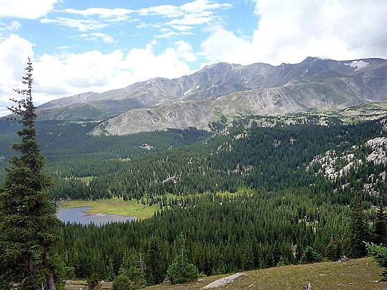
A pretty lake along with terrific views of the Continental Divide and Mt. Massive are a few of the scenic delights along this beautiful trail paralleling the eastern flanks of the Continental Divide west of Leadville.
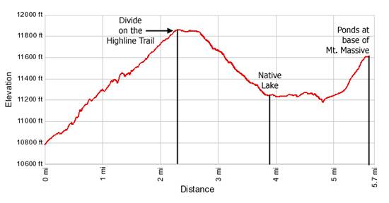
Trailhead to the Divide

Distance from Trailhead: 4.6 miles (round trip)
Ending/Highest Elevation: 11,860-ft.
Elevation Gain: 1,080-ft.
From the parking area (see driving directions) the Native Lake trail immediately enters a thick forest of conifers and starts climbing the ridge defining the south side of the Busk Creek drainage. The trail crosses a stream several times as it ascend a series of long switchbacks on moderate grades up the forested hillside. Well watered meadows around the stream crossings support dense displays of wildflowers. Openings in the trees provide nice views of the Continental Divide to the west.
As you near the top of the ridge the trees thin and views unfold west to the peaks and ridges along the Continental Divide. Two miles from the trailhead the trees give way to sprawling meadows with patches of scrub willows and small copses of stunted firs.
Soon the grade abates and the trail wanders across a high tundra clad plateau with wonderful views of Mt. Massive and the peaks and ridges along the Continental Divide. To the east are expansive views of Leadville framed by a wall of 13,000 and 14,000-ft. peaks. Shortly after reaching the high point of the plateau, the divide between the Busk Creek and Rock Creek drainages, the trail passes to the left of some small picturesque tarns.
Divide to Native Lake

Distance from Trailhead: 7.8 miles (round trip)
Ending/Highest Elevation: 11,240-ft.
Elevation Gain: -620-ft.
At 2.6 miles the trail swings to the west and starts descending to Native Lake. The upper reaches of the decent feature great views of Mt. Massive towering above the valley to the southwest.
The trail drops on moderately steep switchbacks through a rocky basin scattered with trees and then curves south. As you descend the trees thicken. At the bottom of the descent a spur trail leads to pretty Native Lake at 3.9 miles. The lake sits in a marshy basin surrounded by forest. Mt. Massive dominates the scene to the southwest.
Native Lake to the Turnaround Point on the Highline

Distance from Trailhead: 11.2 miles (round trip)
Ending/Highest Elevation: 11,615-ft.
Elevation Gain: 375-ft.
For many hikers Native Lake is a good turnaround point. If you wish to continue along the Highline Trail follow the spur trail back to the main trail and turn left (southeast). The trail, which is difficult to follow at times, leads through the marshy area to the west of Native Lake, crosses the lake’s inlet stream in a willow thicket and then heads back into the trees.
For the next mile the path makes a fairly level traverse through woodlands and pretty meadows, occasionally crossing streams emanating from the aptly named Hidden Lakes, located to the west of the trail. From the meadows enjoy nice views of Mt. Massive and distant views of Leadville and the peaks to the northeast.
At the end of this segment the trail enters a large meadow choked with scrub willows, crosses a stream and then starts to ascend a hillside through meadows. To your right you will see ponds created by the area’s industrious beavers.
Soon the meadows give way to trees and the grade steepens. Near the top of the ascent the trail climbs beside a small stream. At the top of the hill views open to Mt. Massive rising above two small tree-lined lakes (11,615-ft.) at 5.6 miles.
This is the turnaround point for the out-and-back hike. A car shuttle is required to hike beyond this point. From the lakes the Highline Trail turns east and drops through forest to the Evergreen Lakes and the Leadville Fish Hatchery, 9.4 miles from the trailhead.
Elevation Profile
Buy the BookThis opinionated guide includes all the hikes in the Aspen, Buena Vista, Crested Butte, Marble and Leadville sections of the website plus info on local services and nearby attractions. | |

Driving Directions
From US 24 in Leadville, turn west on County Road 4/McWethy Drive and drive 3 miles to a three way “Y” intersection. (Paved to left, dirt in the center, paved to right.) Take the paved road to the right at the intersection to stay on County Road 4, following the signs to Turquoise Lake. Further on the road will travel along the south side of the lake.
Toward the head of the lake reach a “Y” intersection (7.4 miles from US 24) and bear left on the Hagerman Pass Road (Forest Service Road 105) and drive 3.6 miles to the trailhead parking lot, located on the south side of the road.
Trail Resources
Trail Intro / Trail Photo Gallery / Trail Map
Basecamp(s) Information:
Leadville
Region Information:
Central Colorado
Other Hiking Regions in:
Colorado