Details: Hayden Trail 
Distance: 5.0 - 6.6 miles (round trip)
Uncompahgre National Forest, near Ouray in Southwest Colorado
Hike Facts
- Distance: 5.0 - 6.6 miles (round trip)
- Elevation: 9,620-ft. - 12,578-ft.
- Elevation Gain: 2,958-ft.
- Difficulty: strenuous
- Trail Highlights: See Trail Intro
- Basecamp(s): Ouray
- Region: Southwest Colorado
Great views of the peaks rising above Ironton Park are the rewards for this stiff climb up the east facing slopes of Hayden Mountain. A traverse below the Hayden Ridge then leads to a route ascending to Peak 12,578 with terrific views of Yankee Boy Basin.
To Overlook and Peak 12,578
The Hayden Trail is accessible via Highway 550 south of Ouray (Hayden South), and a 4wd road off the Camp Bird Mine Road (Hayden North). I prefer the access via Highway 550 since it is a better trail and does not require a 4WD vehicle (see driving directions below). Both trails feature great views, especially if you climb off-trail to the ridge crest.
The Hayden South trail starts at the northeast end of Crystal Lake in Ironton Park. Here a white metal gate blocks access to a gravel road crossing the dam at the north end of the lake. Parking is provided at a large pullout along the road. Follow the trail around the gate to the trail register and trailhead sign. Sign the trail register and then cross the dam on the gravel road. At the end of the dam is a signed trail junction. Bear right on the Hayden Trail. The Full Moon Trail branches to the left.
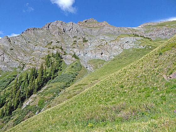
The trail now ascends through trees up the east facing slopes of Hayden Mountain and soon crosses a gully. After a brief stint climbing along the north side of the gully the path turns right and ascends steep log steps up a dirt/scree covered slope.
Past the steps the stiff climbs continues up switchbacks, traveling through aspen groves and pine trees. After a mile the trees give way to meadows and views open to Abrams Mountain (12,801-ft.) across the valley to the east. The trail is now a boot width wide.
At 1.2 miles the trail crosses a gully that carries snowmelt early in the season. Beyond the gully the grade abates as the path ascends through meadows scattered with clumps of evergreens. Hayden Mountain soon comes into view to the west. Red Mountain No. 1, No. 2 and No. 3 dominate the view to the south. Across the valley Brown Mountain, anchored by Abrams Peak, is now in full view.
At 1.6 miles the steep climb resumes as the trail turns to the right and climbs switchbacks up grassy slopes high above the north side of the gully. Hayden Ridge towers overhead. As you climb the views expand to include Storm Peak (13,487-ft.) and summits rising to the north of Silverton.
The trail turns right (north) at 2.0 miles and the grades abates. Wooden stakes and cairns mark the faint path through and undulating landscape of tundra-clad knolls. The trail is now paralleling Hayden Ridge. Ahead views open to the ridge’s sheer rugged cliffs.
At 2.2 miles the trail enters of gully resembling a moonscape of disintegrating gray rock formations. Between the trail and the cliffs is a deep channel draining meltwater from the cliffs. Soon the trail deteriorates as is descends on scree through a rock slide. Loose rock makes the footing precarious in places.
The area has some exposure which some hikers may find uncomfortable. If so, return to the meadows and find a nice place to relax and take in the views.
Thankfully the bad section of the trail is short and we soon return to a faint, boot beaten path through the tundra. Look for stakes to help guide you. Take time to stop here and admire the sea of peak rising across the valley to the east.
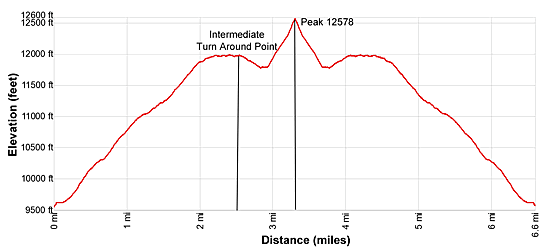
At 2.5 miles the path starts descending on easy to moderate grades as it crosses the top of the West Riverside Slide, a massive avalanche chute. (This is a good turnaround point for parties that don’t want to climb to the ridge crest.) Beyond the slide, the trail continues its descent to a small ravine, actually a tributary of Silver Gulch at 2.9 miles. Use care when crossing the steep scree slopes along the side of the ravine. The area is quite treacherous if the ravine is filled with snow. If snow is present, it might be best to turn around or turn left before the ravine and climb steeply up the Hayden Ridge.
Otherwise, cross the ravine and climb the grassy slopes to a minor ridge at 3.0 miles. Look left here and you will see the steep route to Hayden Ridge. To reach the ridge crest simply climb the grassy slopes of the minor ridge for 0.1 miles to Hayden Ridge. Turn left on the ridge and ascend grassy slopes toward Peak 12,578. The last section is a scramble up scree and rock to the white marker at the top of the peak at 3.3 miles
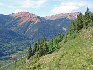
From the summit enjoy fantastic views of Whitehead Mountain, Mount Ridgeway, Teakettle Mountain, Cirque Mountain and Potosi Peak towering above Yankee Boy Basin. The brownish peak in the distance beyond Potosi is Mount Sneffels. Across the valley a sea of summits fill the skyline above the Engineer Pass Road and Bear Creek. Abrams Mountain and Brown Mountain dominate the view to the east while the Red Mountains and the high peaks around Silverton fill the skyline to the south. Closer at hand is Hayden Mountain North (13,139-ft.).
When you are done enjoying the views, descend from the ridge and follow the Hayden Trail back to your vehicle.
Note: The Hayden Trail continues beyond the 3.0 mile point to a saddle and then drops down Squaw Gulch on a steep trail to the Cutler Mine Road, a rough 4WD road that descends to the Camp Bird Mine/Yankee Boy Basin road in one mile. Some call this trailhead Hayden North. Portions of the trail descend steeply down scree covered switchbacks that some hikers find problematic. If you wish to do the point-to-point hike, it is recommended that you climb up from the North trailhead and then descend to the Hayden South trailhead at Ironton Park. The point-to-point hike is 5.6 miles long. Add 2.0 miles round-trip to the hike if you don’t have a 4WD vehicle and need to walk the Cutler Mine Road.
Elevation Profile
| Buy the BookThis opinionated guide includes all the hikes in the Ouray, Telluride, Silverton and Lake City sections of the website plus info on local services and nearby attractions. |
Driving Directions
From Ouray to the Hayden South trailhead: From the center of Ouray (6th Avenue and Main Street), head south on Highway 550-S for 6.4 miles and park at the pullout at the northeast end of Crystal Lake in Ironton Park. As you drive south out of town the road climbs a few switchbacks, travels through a tunnel and then passes the Bear Creek National Recreation Trail parking area, on the left. Soon you will pass the Engineer Pass Jeep Road, also on the left, at 3.9 miles.
At 5.3 miles drive through an avalanche shed. Soon the road climbs a few more switchbacks and then levels off as it reaches Ironton Park. Here you will pass a stone building on the left. A very short distance beyond the stone building the road crossed Red Mountain Creek. On the right (west) side of the road, just past the creek, is a large pullout – park here. The pullout is located at the northeast end of Crystal Lake. A white metal gate blocks a gravel road crossing the dam at the foot of the lake. Beyond the gate is the Hayden trailhead sign and a trail register.
From Ouray to the Hayden North trailhead: From the center of Ouray (6th Avenue and Main Street), head south on Highway 550-S for 0.6 miles. At the south end of town the road climbs switchbacks. As you round the top of the hairpin curve on the first switchback watch for a road off to the right. This is County Road 361 leading to the Camp Bird Mine and Yankee Boy Basin. Turn right onto County Road 361 and follow the road for 1.7 miles and turn left on the 4WD Cutler Mine Road. There should be a sign for the Hayden Trail at the intersection. Keep left as you ascend the steep, rugged road to avoid McNulty Lane on the right. Bear right at the second fork. The trailhead is located one mile up the road and is marked with a wood sign. There is very limited parking at the trailhead.
Trail Resources
Trail Intro / Trail Photo Gallery / Trail Map
Basecamp(s) Information:
Ouray
Region Information:
Southwest Colorado
Other Hiking Regions in:
Colorado