Details: Middle Fork Cimarron Trail 
Distance: 6.2 - 11.0 miles (round trip)
Uncompahgre Wilderness Area, Uncompahgre National Forest, near Ouray in Southwest Colorado
Hike Facts
- Distance: 6.2 - 11.0 miles (round trip)
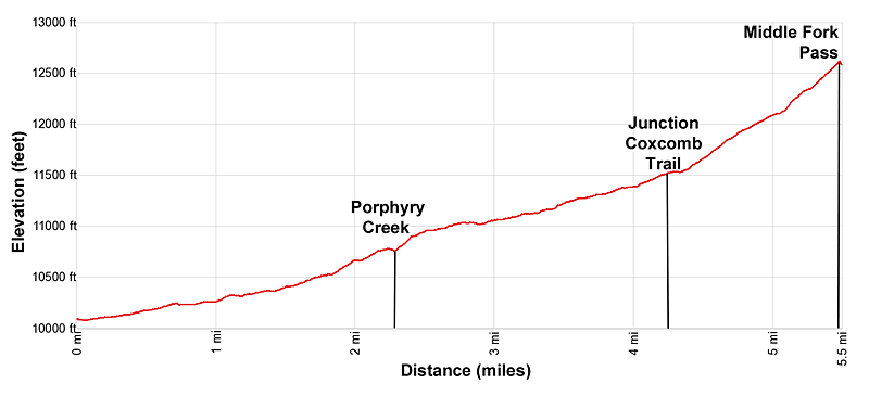
- Elevation: 10,080-ft. - 12,595-ft.
- Elevation Gain: 2,515-ft.
- Difficulty: moderate-strenuous
- Trail Highlights: See Trail Intro
- Basecamp(s): Ouray
- Region: Southwest Colorado
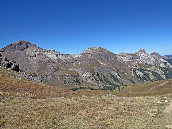
View of Dunsinane Mountain, Precipice Peak, Redcliff Peak and Coxcomb Peak accompany hikers on this long hike up the scenic Middle Fork Cimarron Valley. A final steep climb leads to Middle Fork Pass with spectacular views of Uncompahgre, Wetterhorn and Matterhorn Peaks.
Middle Fork Cimarron

The Middle Fork Cimarron Trail starts at the end of the Middle Fork Road (see driving directions below). The trail travels a short distance through trees before emerging into a meadow. Here views open to the rugged slopes and ridges rimming both sides of the valley.
The path now ascends gently along the east banks of the Middle Fork Cimarron River. Numerous rock slides and avalanches have filled the river bed with rocks. Behind you, to the west, are fine views of the aptly named Turret Ridge.
Soon the trail enters the trees as it continues up the east side of the valley on easy to moderate grades, entering the Uncompahgre Wilderness Area at 0.3 miles. Openings in the trees and small meadows offer views to the west of Dunsinane Mountain and Precipice Peak, with slopes sculpted by wind and water into photogenic pinnacles and spires.
At 1.2 miles the views open to an avalanche chute on the slopes beneath Dunsinane Mountain. This is the first of several rockslides you will see that are reshaping the valley and spilling debris into the river bed. A second slide is seen spilling down the slopes of Precipice Peak at 1.4 miles. A third slide, this time on the east side of the valley, is crossed at 1.6 miles.
At 2.25 miles the path reaches a junction with the trail to Porphyry Basin branching left. This old mining trail climbs steeply for a mile up a creek drainage to an overlook above Porphyry Basin at 12,300-ft.
Past the junction the trail soon descends to and crosses Porphyry Creek near its confluence with the Middle Fork. After the crossing, the trail makes a short, steep climb before resuming its ascent on easy to moderately-easy grades through forest up the east side of the valley.
At 3.1 miles the trail breaks from the trees and beautiful views open to the cirque at the head of the valley, dominated by Redcliff and Coxcomb Peaks to the southwest and the Heisshorn to the southeast. A short distance beyond a waterfall is seen spilling down a rugged drainage to the east. Enjoy ever improving views of the cirque as you hike up the pretty meadows toward the head of the valley. Hikers looking for a shorter day can turn around here or anywhere in the next miles before the trail starts the stiff climb up to Middle Fork Pass.
At 3.8 miles a second waterfall is seen to the east. Beyond the falls the trail briefly reenters the trees before continuing through meadows, fringed with trees, toward the head of the valley. Nice campsites can be found along this section of the trail.
Reach the junction with the Coxcomb Trail, branching right, at 4.25 miles. This faint trail, initially marked with stakes, ascends steeply to Coxcomb Pass before descending into Wetterhorn Basin. We bear left on the continuation of the Middle Fork Trail.
Our trail soon reenters the trees and swings to the left (southeast). The path now climbs on moderately-steep grades through trees and meadows up the cirque’s southeast slopes toward Middle Fork Pass.
At 4.75 miles we leave the trees behind and continue ascending on moderately-steep grades up alpine meadows. Take a break from the stiff climb to enjoy great views of Coxcomb, Redcliff, Fortress and Precipice Peaks towering above the west side of the valley. El Punto rises to the northeast.
At 5.1 miles the grade steepens as the trail curves to the right. The pass, a saddle on the ridge to the southeast, slowly comes into view as you climb through rocky meadows.
As you crest Middle Fork Pass (12,595-ft.) a spectacular scene springs into view. To the south the Matterhorn (13,590-ft.) and Wetterhorn (14,015-ft.) dominate the skyline, connected by serrated ridge. The distinctive profile of Uncompahgre Peak (14,309-ft.) stands alone to the southeast. The Heisshorn rises above the west side of the pass.
A trail continues down the south side of the pass into the East Fork drainage providing access to trails/routes climbing the Wetterhorn, Matterhorn and Uncompahgre Peak. Looking at the map will show some great, albeit challenging, backpacking options. One easier option is to do the point to point backpack combining the Middle Fork and East Fork trails. (A car shuttle or long walk on the road is required to close the loop.) From the pass its 2.5 miles to the East Fork Trail and then 8.4 miles down the East Fork to the East Fork trailhead.
Elevation Profile
| Buy the BookThis opinionated guide includes all the hikes in the Ouray, Telluride, Silverton and Lake City sections of the website plus info on local services and nearby attractions. |
Driving Directions
Driving directions from Ouray: Head north from Ouray on US Highway 550 for just under 12 miles and turn right (east) onto Owl Creek Road (CR10 - Ouray County 10). The turn is 1.8 miles past the turnoff to Ridgway (Highway 62). Follow the signs to Owl Creek Pass (14.9 miles). Along the way the macadam gives way to a good dirt/gravel road and CR 10 turns into CR 8 and then FR 858 after crossing into the Uncompahgre National Forest. Views on the ride encompass Courthouse Mountain and Chimney Rock.
Beyond Owl Creek Pass the road become Forest Road 860 and soon passes the West Fork Road (860 A), which leads to the trailhead for Wetterhorn Basin. Continue on Forest Road 860 for a total of 6.7 miles and then turn right on the Forest Road 861. Continue on FR 861 for 4.6 miles to the trailhead located at the head of the loop at the end of the road. Parking spots are found along the loop. The drive from Ouray should take 1 hour and 40 minutes under good conditions.
During good conditions a 2WD vehicle with reasonable clearance should be able to reach the trailhead. Check at the Ouray Visitor Center or call the Ouray Office of the Grand Mesa, Uncompahgre and Gunnison National Forest for current road conditions.
Trail Resources
Trail Intro / Trail Photo Gallery / Trail Map
Basecamp(s) Information:
Ouray
Region Information:
Southwest Colorado
Other Hiking Regions in:
Colorado