Details: Richmond Pass 
Distance: 5.6 miles (round trip)
Uncompahgre National Forest, near Ouray in Southwest Colorado
Hike Facts
- Distance: 5.6 miles (round trip)
- Elevation: 9,910-ft. - 12,693-ft.
- Elevation Gain: 2,783-ft.
- Difficulty: strenuous
- Trail Highlights: See Trail Intro
- Basecamp(s): Ouray
- Region: Southwest Colorado
Terrific views of the high peaks towering above the Million Dollar Highway and Yankee Boy Basin are the rewards of this steep climb to a scenic pass to the south of Hayden Mountain.
Trailhead to Richmond Pass

The Richmond Pass trailhead is located along Highway 550 at the south end of the Ironton Park area near Ouray, Colorado. (See driving directions below.) From the parking area walk 200-ft. west up an old road paralleling the highway to a trailhead sign listing the mileage to Richmond Pass, 2.4 miles, and the Richmond Basin Road, 3.7 miles. (My GPS measurements found the trail to be a little longer.)
Beyond the sign the road curves to the right and soon becomes a trail. A short distance beyond is a trail register. Past the register the trail starts climbing through aspen on a series of moderately-steep to steep switchbacks.
After walking a half mile openings in the trees offer views of Red Mountain No 2 (12,219-ft.) and No 3 (12,890-ft.) to the south. Brown Mountain (13,339-ft.) rises across the valley to the east. As you ascend the aspen give way to evergreens and small meadows with ever improving views of the colorful Red Mountains.
After hiking 1.2 miles reach a small sign in a meadow pointing right toward the continuation of the trail. Ignore the old, faded pack trail heading left (west) near the sign. From the meadow distant views open to the Twin Sisters, two distinctive peaks rising to the southwest. Closer at hand are the 13,000-ft. peaks at the head of McIntyre Gulch, the valley to the southwest.
At 1.7 miles we leave the last of the trees behind and reach the top of the switchbacks. To the northeast are fine views of Abrams Mountain (12,801-ft.), the northern most peak along the Brown Mountain Ridge. Here a trail sign marks the junction with the Full Moon trail, a faint track heading right (northeast). We bear left (west) on the Richmond Trail.
Keep an eye on the weather as you continue the hike. You are now above the timberline and completely exposed. Turn around if thunderstorms are threatening.
The trail now climbs steeply along a dirt/scree covered slope before leveling out at 2.0 miles atop a tundra clad ridge separating McIntyre Gulch, to the south, and Full Moon Gulch, to the north. The pass is now in sight, the saddle at the head of the ridge between Hayden Mountain (13,206-ft.) to the north and Peak 13,011 to the south. From this vantage point enjoy fabulous views of the Red Mountains across the valley to the southeast.
The trail now become a little faint as it drops into a small bowl. Rock cairns make the trail as it travels through the bowl. Look ahead to see a stake marking where the trail climbs out of the bowl.
Beyond the bowl the steep climb up the ridge is accompanied by stunning views of the rugged peaks at the head of McIntyre Gulch, Hayden Mountain, the Red Mountains and Brown Mountain. A sea of high peaks fills the skyline to the northeast. On a clear day the tops of Wetterhorn and Uncompahgre Peak, two 14,000-ers, are visible. To the southwest the high peaks along the Mineral Creek Valley and beyond dominate the view.
At 2.3 miles the trail curves to the right as it climbs around a low hill. The trail is faint through this section.
Soon you reach a rock cairn with a stake. Here the trail splits. The obvious trail to the right is the lower trail. The path branching left is the high trail, which initially is very faint but becomes clearer as you climb.
The lower trail is slightly longer and used early in the season to circumvent a snow cornice on the ridge. The higher route, which is more direct, is preferred once the snow melts on the ridge top. As you near the pass the higher trail crosses scree covered slopes.
Crest Richmond Pass (12,667-ft.) at 2.6 miles. Here amazing views open to Yankee Boy Basin to the northwest. Gilpin Peak (13,694-ft.), Mount Sneffels (14,150-ft.) and Potosi Peak (13,786-ft.) tower above the basin. Cirque Mountain (13,686-ft.) and Teakettle Mountain (13,819-ft.) rise between Mount Sneffels and Potosi Peak. The Yankee Boy Basin Road (aka County Road 361) is seen snaking up the valley floor.
The Richmond Pass Trail continues over the pass, dropping steeply down the western slopes of Hayden Mountain on an old pack trail. The trail ends at a jeep road which descends to the Imogene Pass Road. A car shuttle is required for this point to point hike. Two use/social trails branch right (north) from the pass, leading to the summit of Hayden Mountain South.
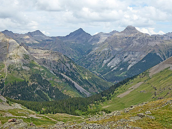
My recommendation is to take the use/social trail branching left from the pass. This trail crosses a bench on an undulating path with more fine views of Yankee Boy Basin. Continue along the bench for 0.2 miles to a viewpoint at the end of the bench at 2.8 miles. Below the bench you will see a mining road climbing Richmond Basin. Chicago Peak (13,385-ft.) rises along the ridge to the west. The viewpoint is an excellent place to have lunch and soak in the views.
From the viewpoint, retrace your steps to the trailhead for a 5.6 mile hike. The views are even better on the way down since you are facing the Red Mountain area.
From the bench it is possible to drop down to the mining road and then descend the road to the junction with the Imogene Pass Road (about 3 miles). From the junction it is a 2.3 mile to the Yankee Boy Basin Road. Again, this option would require a car drop. The length of the point to point hike could be shortened by driving the shuttle vehicle up the Imogene Pass Road to the junction with the Richmond Basin Mining Road. Note: The Imogene Pass Road requires a high clearance, 4WD vehicle. Check with the Ouray Visitor Center on current road conditions before trying this point-to-point hike.
Note: The unmarked trailhead for this hike, located along Highway 550 near the southern end of Ironton Park, is easy to miss. Pay close attention to the driving directions (below). Highway 550 south of Ouray is a narrow, curvy road with spectacular views. It is easy to drive by the unmarked turn while you are admiring the scenery.
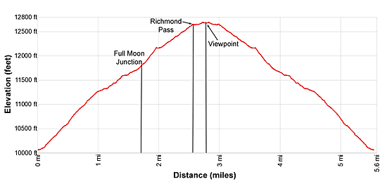
Elevation Profile
| Buy the BookThis opinionated guide includes all the hikes in the Ouray, Telluride, Silverton and Lake City sections of the website plus info on local services and nearby attractions. |
Driving Directions
Driving Directions from Ouray: From the center of Ouray (6th Avenue and Main Street), head south on Highway 550-S for 8.7 miles and turn right (northeast) onto an unmarked spur road leading to the trailhead parking area. (The turnoff is 9.1 miles from the Ouray Visitor Center adjacent to the Hot Springs.)
Finding this road might be the hardest part of the hike. To help you locate the turnoff I am including some landmarks and intermediate distances.
As you drive south out of town the road climbs a few switchbacks, travels through a tunnel and then passes the Bear Creek National Recreation Trail parking area, on the left (east), and then the Engineer Pass Jeep Road, also on the left (east), at 3.9 miles.
At 5.3 miles drive through an avalanche shed. Soon the road climbs a few more switchbacks and then levels off as it reaches Ironton Park. Here you will pass a stone building, on the left (east), and Crystal Lake, on the right (west).
At 7.9 miles pass a road and a large parking lot on the left (southwest), just before a large reclamation site. Now you need to really pay attention. Soon you will see the ruins of a wood building, the schoolhouse for the Larson Brother’s mine, on the right (northeast).
Travel 0.8 miles past the schoolhouse and turn right onto an unmarked dirt road. This will be the next right turn after the schoolhouse and is very easy to miss if you are not paying attention. You’ve missed the turn if you pass a large gravel pull-off on the left and then start up some switchbacks.
Follow the spur road for a short distance and then turn left on a dirt track. There will be a pile of mine tailings to the right of the turnoff. The dirt track leads to a small parking area where you will see a sign for the Richmond Trailhead.
The GPS coordinates for the turnoff: 37.988587, -107.649762
Trail Resources
Trail Intro / Trail Photo Gallery / Trail Map
Basecamp(s) Information:
Ouray
Region Information:
Southwest Colorado
Other Hiking Regions in:
Colorado