Details: Upper Cascade Falls / Chief Ouray Mine 
Distance: 4.4 - 5.9 miles (round trip)
Uncompahgre National Forest, near Ouray in Southwest Colorado
Hike Facts
- Distance: 4.4 - 5.9 miles (round trip)
- Elevation: 8,500-ft. - 10,030-ft.
- Elevation Gain: 1,530-ft.
- Difficulty: moderate-strenuous
- Trail Highlights: See Trail Intro
- Basecamp(s): Ouray
- Region: Southwest Colorado
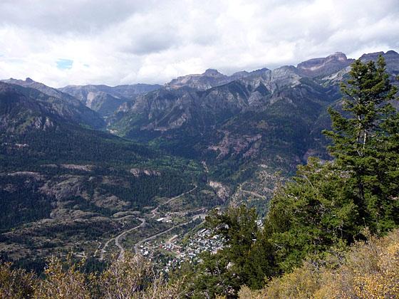
This great half day hike climbing high above the eastern side of Ouray features fabulous views of the Uncompahgre Valley, Cascade Falls and the Amphitheatre.
Trailhead to Upper Cascade Falls

Distance from Trailhead: 4.4 miles (round trip)
Ending/Highest Elevation: 10,030-ft.
Elevation Gain: 1,530-ft.
The trail to Upper Cascade Falls starts at the southeast end of a small parking area at the top of the Amphitheater Campground (see driving directions below). Follow the trail for 0.2 miles as it contours along the hillside to a trail junction. At the junction turn left on the Upper Cascade Falls trail toward the Chief Ouray Mine. The trail to the right, the Portland Trail, can be used as a return leg of an extended loop hike.
Climb through scrub oaks and mixed conifers to a second junction, located just over 0.5 miles from the trailhead. Stay on the Upper Cascade trail heading toward the Chief Ouray Mine. The trail to the left heads downhill toward the campground and Lower Cascade falls. This section of the trail enjoys nice views to the west and southwest toward Potosi Peak and Hayden Mountain.
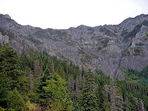
Beyond the junction the grade steepens. Openings in the foliage offer tantalizing views of the sculpted walls of the amphitheater circling the eastern end of the basin. After hiking 0.3 miles reach a second junction with the Portland trail, which branches right. We bear left, following the signs toward Chief Ouray Mine.
The trail now ascends a dry hillside on steep switchbacks, gaining over 1,100-ft in just under a mile. As you climb enjoy wonderful views of the amphitheatre. Hayden Mountain and the peaks and ridges around Potosi Peak dominate the scene to the west and southwest.
At the top of the switchback the path traverses a rocky ledge and crosses a ridge. Vantage points along the path offer views of Twin Peaks and the Sneffels range to the west and the town of Ouray 2,300-ft below.
After crossing the ridge the trail curves northeast (right) and descends through trees for 0.3 miles to cross the creek at Upper Cascade Falls. Openings in the trees provide views of the Chief Ouray bunkhouse building across the drainage. (The bunkhouse is a light blue metal building.)
There are actually two waterfalls, one above the trail and one below. The waterfall below the trail can be heard but not seen.
After enjoy the secluded area around the falls you can either return the way you came or walk another 0.2 miles to the mine buildings. This section of the trail is not recommended for people with a fear of heights.
Return via the Portland Trail
Distance from Trailhead: 5.9 miles (loop)
Ending/Highest Elevation: 10,030-ft.
Elevation Gain: 1,530-ft.
Return the way you came or extend the hike by turning left (east) onto the Portland trail. The junction is located at the base of the switchbacks. Returning via the well signed Portland trail adds 1.5 miles to the hike and is highly recommended. The trail features wonderful views of the amphitheatre and the peaks rising to the south and west of Ouray. See the Portland trail description for more information.
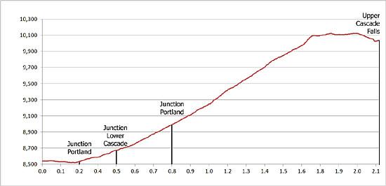
Elevation Profile
| Buy the BookThis opinionated guide includes all the hikes in the Ouray, Telluride, Silverton and Lake City sections of the website plus info on local services and nearby attractions. |

Driving Directions
From Ouray: Drive south from Ouray on Highway 550 for just over a mile to the Amphitheatre Campground and turn left onto the campground access road. The turnoff is past the second switchback leaving town. Follow the paved road into the campground for 1.25 miles, keeping left at all intersections. The trailhead, marked for the Upper Cascade trail, is located at the top of the campground. A good hand-drawn map on a signpost at the trailhead shows the interconnecting trail system that includes the Portland Trail, the Upper and Lower Cascade Falls trails and the Portland Mine Road.
If walking from Ouray, walk up 8th Ave to Lower Cascade Falls, turn right (south) on the Perimeter trail for 0.2 miles to a junction. Turn left (east) and ascend on the Lower Cascade Connector Trail for 0.6 miles to the Cascade/Portland trail. Turn left on the Cascade/Portland trail (the second junction at 0.5 miles in the description above) toward Upper Cascade Falls.
Trail Resources
Trail Intro / Trail Photo Gallery / Trail Map
Basecamp(s) Information:
Ouray
Region Information:
Southwest Colorado
Other Hiking Regions in:
Colorado