Details: Wetterhorn Basin 
Distance: 5.8 - 9.0 miles (round trip)
Uncompahgre Wilderness Area, Uncompahgre National Forest, near Ouray in Southwest Colorado
Hike Facts
- Distance: 5.8 - 9.0 miles (round trip)
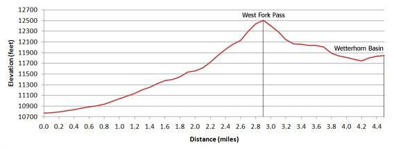
- Elevation: 10,760-ft. - 12,517-ft.
- Elevation Gain: 1,757-ft.
- Difficulty: moderate
- Trail Highlights: See Trail Intro
- Basecamp(s): Ouray
- Region: Southwest Colorado
This trail wanders through wildflower-filled meadows and then climbs a gorgeous alpine basin to West Fork Pass. From the pass the trail drops into scenic Wetterhorn Basin with view of Wetterhorn Peak (14,015-ft.).
Trailhead to West Fork Pass

Distance from Trailhead: 5.8 miles (round trip)
Ending/Highest Elevation: 12,517-ft.
Elevation Gain: 1,757-ft.
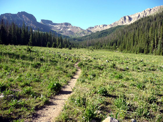
Few trails boast the stunning views seen from the start of the Wetterhorn Basin hike. From the 4WD trailhead (see driving directions below) Redcliff and Coxcomb Peaks dominate the view at the head of the valley, rising above flower-filled meadows and spruce-fir forests. Our destination is the pass to the west of Coxcomb.
The well-defined trail stays to the left (east) of the West Fork of the Cimarron river, ascending on easy gradient through open meadows before entering the forest at 0.7 miles. Openings in the trees provide intermittent views of the surrounding ridges defining the valley. Along the way the trail crosses side steams and avalanche chutes, emerging at a beautiful alpine basin at the head of the valley in just over 1.6 miles (11,370-ft.).
Cross a small stream and head west across the basin to a series of switchbacks ascending toward the pass through grassy meadows sprinkled with columbines, Indian paintbrush and buttercups. As you climb the trail crosses to the west side of the West Fork, now just a pretty stream cascading down the hillside.
Across the valley Precipice, Fortress, Redcliff and Coxcomb peaks punctuate the ridge forming the valley’s eastern wall. To the north views open to distinctive Courthouse Mountain and Chimney Rock.
The grade abates briefly before ascending a steep slope of loose talus and boulders. Beyond the talus the trail climbs a grassy knoll dotted with wildflowers, reaching West Fork Pass (12,517-ft.) in 2.9-miles after gaining 1,757-ft.
Coxcomb Peak rises to the east of the pass. To the south enjoy great views of the peaks and ridges towering above the Wetterhorn and Cow Creek drainages – but not of Wetterhorn Peak.
Pass to Wetterhorn Lookout

Distance from Trailhead: 6.8 miles (round trip)
Ending/Highest Elevation: 12,256-ft.
Elevation Gain: -261-ft.
To see Wetterhorn Peak climb a short distance up the ridge to the west or follow the obvious use trail contouring to the west just below the south side of the pass. The idea is to get above or to the right (west) of a ridge extending from Coxcomb Peak that is blocking the view of Wetterhorn Peak.
For more expansive views I recommend hiking down the south side of the pass for about 0.3 miles (losing about 330-ft.) and then heading right (west) across a rocky meadow to an obvious use trail climbing steeply 100-ft. up a ridge jutting into the basin. From the end of the ridge enjoy stunning views of Wetterhorn Peak towering above the emerald green basin and bird’s eye views into Cow Creek and Wetterhorn creek drainages to the south. The Mt. Sneffels range graces the skyline to the west.
Pass to Wetterhorn Basin

Distance from Trailhead: 9.0 miles (round trip)
Ending/Highest Elevation: 11,850-ft.
Elevation Gain: -667-ft.
For a more intimate view of Wetterhorn Peak follow the trail down the south side of the pass into the basin. The trail drops over 750-ft. then climbs about 100-ft. to Wetterhorn Creek in 1.6 miles. (Total round trip from the trailhead to the creek is 9-miles.) From this vantage point pyramid-shaped Wetterhorn Peak pierces the skyline to the east while distinctive Coxcomb Peak looms to the north.
Elevation Profile
| Buy the BookThis opinionated guide includes all the hikes in the Ouray, Telluride, Silverton and Lake City sections of the website plus info on local services and nearby attractions. |
Driving Directions
Driving directions from Ouray: Head north from Ouray on US Highway 550 for just under 12 miles and turn right (east) onto Owl Creek Road (CR10 - Ouray County 10). The turn is 1.8 miles past the turnoff to Ridgway (Highway 62). Follow the signs to Owl Creek Pass (14.9 miles). Along the way CR 10 turns into CR 8 and then FR 858 after crossing into the Uncompahgre National Forest. Along the way enjoy views of Courthouse Mountain and Chimney Rock. Continue over the pass for 0.3 miles to FR 860 (West Fork Road). Turn right and follow FR 860 for 3.3 miles to the trailhead with ample parking. High clearance/4WD is required for the last 1.5 miles of the road which is very rocky and includes a creek crossing that can be problematic.
Trail Resources
Trail Intro / Trail Photo Gallery / Trail Map
Basecamp(s) Information:
Ouray
Region Information:
Southwest Colorado
Other Hiking Regions in:
Colorado