Details: Crater Lake 
Distance: 11.0 - 11.8 miles (round trip)
Weminuche Wilderness Area, San Juan National Forest, near Silverton in Southwest Colorado
Hike Facts
- Distance: 11.0 - 11.8 miles (round trip)
- Elevation: 10,770-ft. - 11,770-ft.
- Elevation Gain: 870-ft. - 1,000-ft.
- Difficulty: moderate
- Trail Highlights: See Trail Intro
- Basecamp(s): Silverton / Ouray
- Region: Southwest Colorado
A scenic hike to a pretty lake nestled beneath North Twilight Peak (13,075). The hike can be extended by hiking to the saddle beyond the lake and/or scrambling to the top of North Twilight.
Trailhead to Crater Lake
Distance from Trailhead: 11.0 miles (round trip)
Ending/Highest Elevation: 11,640-ft.
Elevation Gain: 870-ft.
In 1993 Congress expanded the Weminuche Wilderness to include the rugged West Needle Mountains, wedged between a deep gorge of the Animas River and Lime Creek to the south of Molas Pass. Only one trail, Crater Lake, penetrates this segment of the wilderness.
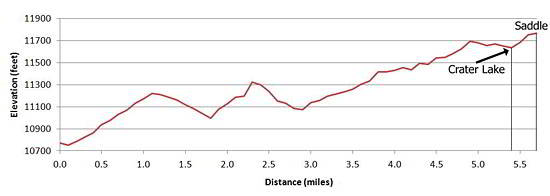
The hike to Crater Lake starts at pretty Andrews Lake, a popular fishing spot just south of Molas Pass (see driving directions). Starting at the southwest end of the parking area the trail skirts the west shore of the lake, crosses a meadow and ascends a tree covered hillside on switchbacks, gaining 450-ft. in 1.1 miles. This is the steepest climb of the hike.
Views from the meadows around Andrews, along with intermittent views from openings in the trees while climbing the hillside, include West Turkshead (12,849-ft.) and Grand Turk (13,180-ft.) to the north, Twin Sisters (13,432 and 13,372) and Jura Knob (12,594) rising on the ridge to the west and Snowdon Peak to the southeast.
From the top of the hill the trail drops 240-feet into a drainage traversing pretty meadows with pockets of Engelmann spruce and firs. A second climb gains 370-ft. reaching the top of a hill at 2.4 miles.
Beyond the second climb the trail descends on moderate grades for 0.4 miles and then ascends on easy to moderate grades through meadows and forests for 1.6 miles, gaining 400-ft. Openings offer great views of Engineer Mountain (12,968-ft.), Jura Knob and Twin Sisters to the west. As the trail swings east views open to North Twilight Peak (13,075) to the south.
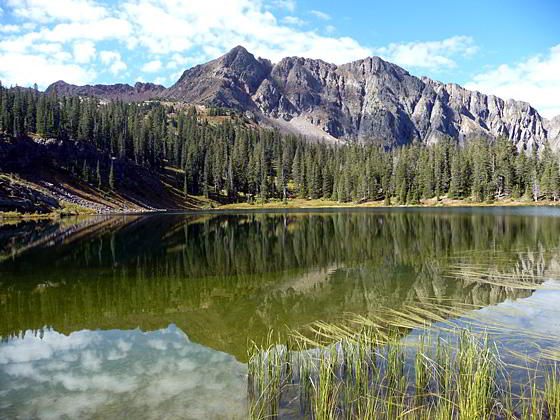
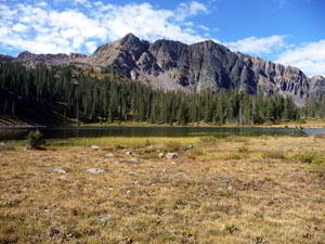
At 4.0 miles the path enters heavy timber and stays in the woods for the next 1.1 miles. At 5.1 miles the trail drops into a small depression, skirts a marshy area to your left (east), and then climbs over a hill to the basin holding Crater Lake (11,640-ft.) at 5.5 miles. North Twilight Peak, rising to the southwest, forms the perfect backdrop for this pretty lake ringed by a forest.
Photographers will snap plenty of pictures of North Twilight Peak reflected in the lake’s still waters. Fishermen may want to try their luck at catching some of the lake's cutthroat trout. Numerous camping areas are evident in the trees to the north and west of the lake.
Crater Lake to the Saddle
Distance from Trailhead: 11.8 miles (round trip)
Ending/Highest Elevation: 11,770-ft.
Elevation Gain: 1,000-ft.
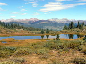
For panoramic views of the peaks to the west and south of Molas Pass along with a restricted view of the Needles, hike to the obvious saddle (11,770-ft.) southwest of the lake. The faint trail swings around the east side of the lake and proceeds up a grassy slope, skirting rock piles and a small pond. Round trip to the saddle is 0.4 miles with a 130-ft. elevation gain.
To climb North Twilight Peak (13,075-ft) proceeds west from the saddle, climbing the mountain’s northeast shoulder and east ridge. The class 2-3 scramble requires a head for heights when crossing a narrow exposed ridge. Panoramic views from the top provide a bird’s eye view of the Needles and the Grenadier Range to the east. Total elevation gain from the trailhead is 2,305-ft. Note: The climb to North Twilight Peak is recommended for experienced parties only.
Elevation Profile
| Buy the BookThis opinionated guide includes all the hikes in the Ouray, Telluride, Silverton and Lake City sections of the website plus info on local services and nearby attractions. |
Driving Directions
Driving directions from Silverton: From the intersection of Main Street in Silverton (State Highway 110) and U.S. 550, drive south on U.S. 550 for 7.3 miles to the Andrews Lake Road. It is 6.4 miles to the top of Molas Pass. Andrews Lake Road is 0.94 miles beyond the pass. Turn left and drive a little over 0.5 mile on the narrow paved road to the parking area at Andrews Lake. The trailhead is located on the southwest end of the parking area.
Driving Directions from Ouray: Drive south on U.S. 550 for 30.7 miles to the Andrews Lake Road. Andrews Lake Road is 0.94 miles beyond Molas pass. Turn left and drive a little over 0.5 mile on the narrow paved road to the parking area at Andrews Lake. The trailhead is located on the southwest end of the parking area.
Driving directions from Durango: Drive 45-miles north of Durango on US 550 to the Andrews Lake turn off. The turn off is 6.6 miles beyond Coal Bank Pass and about 0.5 miles from the Lime Creek rest area. Turn right and drive a little over 0.5 mile on the narrow paved road to the parking area at the lake. The trailhead is located on the southwest end of the parking area.
Trail Resources
Trail Intro / Trail Photo Gallery / Trail Map
Basecamp(s) Information:
Silverton / Ouray
Region Information:
Southwest Colorado
Other Hiking Regions in:
Colorado