Details: Highland Mary Lakes 
Distance: 6.0 - 7.7 miles (round trip)
Weminuche Wilderness, San Juan National Forest, near Silverton in Southwest Colorado
By: Diane Greer
Hike Facts
- Distance: 6.0 - 7.7 miles (round trip)
- Elevation: 10,790-ft. - 12,580-ft.
- Elevation Gain: 1,530-ft. - 1,790-ft.
- Difficulty: moderate-strenuous
- Trail Highlights: See Trail Intro
- Basecamp(s): Silverton
- Region: Southwest Colorado
This trail ascends to gorgeous lakes set amid scenic alpine meadows with terrific views. An optional extension follows a segment of the Continental Divide, turning the hike into a loop with extended views of the surrounding peaks
Trailhead to Verde Lakes
Distance from Trailhead: 6.0 miles (round trip)
Ending/Highest Elevation: 12,320-ft.
Elevation Gain: 1,530-ft.
The Highland Mary Lakes trails starts just beyond the 4WD parking lot at a sign with a large map of the Weminuche Wilderness. (See driving directions below.) Before this sign there is an old wood sign pointing left (east) to the Continental Divide Trail (CDT) -- aka the Cunningham Gulch trail -- and right (south) for the Highland Mary Lakes trail.
The Highland Mary Lakes trail wastes no time gaining elevation, ascending on moderately-steep grades through forest interspersed with meadows, staying to the left (east) of Cunningham Creek. Just beyond a waterfall reach a junction (0.2 miles) pointing left to the CDT and straight ahead for the Highland Mary Lakes trail. The trail to the left provides alternative access to the Cunningham Gulch trail and is the return leg of the loop hike.
The trail becomes more rugged as it ascends, occasionally crossing minor creeks with pretty waterfalls. An open area by one of the falls provides nice views to the north.
After climbing for about 30 minutes (1.0 mile) and gaining 860-ft., the trail cross to the right (west) side of the creek and ascends steeply up a rock outcropping. Soon the forest gives way to a picturesque basin with diverse ground cover and small copses of trees set amid rocky knobs. Follow the trail as it curves to the right (west) through the basin and climbs a minor drainage, staying to the right (north) of the creek.
Soon the route turns south again, ascending a steep slope beside the stream. At the base of the talus field the trail forks. Either trail will get you to your destination. I prefer the trail to the left unless the drainage is covered in snow.
The trail to the left climbs steeply up the drainage, hugging the right (west) side of the creek. About halfway up the hill rock cairns mark a crossing to the left (east) side of the creek for the remainder of the climb. The trail to the right climbs up the talus field and then swings to the left, climbing above the talus before swinging left again and crossing a boulder field, a small meadow and the creek to meet the first trail.
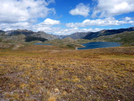
A short distance beyond where the two trails meet the first Highland Mary Lake (12,080-ft.) pops into view at 1.7 miles (1,330-ft. ascent from the trailhead). The second lake is soon seen on the right (south) as the trail crosses the narrow strip of land separating the two lakes. This is a great spot to take a break and enjoy the beautiful views to the north of the peaks lining the Cunningham Creek Valley and Spencer Basin to the northwest.
Continue the hike by following the trail as it swings around to the right and travels along the eastern side of the second lake. Views soon open to the left (east) to the third and largest of the Highland Mary lakes (12,090-ft.).
At the top of the third lake the path drops into a marshy area and becomes a little hard to follow as it crosses one of the lake’s inlet streams at 2.3 miles. To stay on track, look for wooden post on the hillside above the marsh. As you head toward the post the continuation of the trail, a boot beaten path through the meadows, becomes evident to the left of the post.
A second wooden post in the distance will help keep you on track as the trail climbs gently south across the beautiful alpine meadows. The open landscape offers terrific views of the surrounding peaks and ridges. To the north views extend to Sugarloaf (12,754-ft.), Little Giant Peak (13,416-ft.), Green Mountain (13,049-ft.) and beyond. To the northwest Mount Rhoda (13,402-ft.) and Peak 13,434-ft. dominate the view.
As you crest the hill views open south to the Grenadier Range, with the distinctive pyramid-shaped West Trinity (13,765-ft.), Vestal (13,864-ft.) and Arrow (13,803-ft.) peaks (from left to right). The large massif on the horizon is Peak 2 (13,475-ft.).
The trail now traverses rolling alpine meadows. At 2.9 miles reach an overlook above the Verde Lakes (12,186-ft.). White Dome (13,627-ft.), Peak 1 (13,589-ft.), Storm King Peak (13,752-ft.) and Peak 2 dominate the view to the south while two unnamed 13,000-ft. peaks rise to the east. Follow the path as it descends on easy grades to the lakeshore at 3.0 miles and continues along the east side of the lake. A short distance beyond the lake the trail fades.
Although Verde Lakes are the turnaround point for the out-and-back hike, the open alpine tundra invites exploration. A quick look at the map will show a number of smaller lakes within the vicinity worth visiting. Be sure to keep an eye on the weather while you explore the basin. The open alpine tundra is exposed and not a good place to be caught in a thunderstorm.
Loop option with Continental Divide extension
Distance from Trailhead: 7.7 miles (loop)
Ending/Highest Elevation: 12,580-ft.
Elevation Gain: 1,790-ft.
If you wish to do the loop hike, return to the overlook above Verde Lakes. Facing the lake, look up the hillside to the left (east) to locate a wooden post marking the trail to the Continental Divide. Climb the hill toward the posts. Soon an obvious trail appears. On the ascent be sure to turn around and enjoy terrific views of the Grenadiers with West Trinity, Vestal and Arrow Peaks easy to pick out on the skyline. Below you Verde Lakes, set against a backdrop of the high peaks to the north/northwest, lies nestle in alpine meadows. The views continue to improve as you climb.
Reach the high point on this segment of the trail at 3.5 miles. Here the trail briefly levels out. At 3.9 miles the trail curves to the left (northeast) and starts a short steep descent along the north side of a deep gully carrying a stream draining the western slopes of the Continental Divide.
Soon the descent ends and the trail begins ascending on moderate grades through alpine meadows along the west side of the creek. Posts help mark this section of the trail.
Hop across the stream at 4.2 miles and continue climbing toward the Continental Divide along the east side of the stream. Be sure to turn around for more fine views of Vestal and Arrow Peaks.
At 4.6 miles the grade abates as the trail curves to the left (north). To our right (east) another boot beaten path is seen paralleling our trail. This is the Continental Divide Trail (CDT). At 4.8 miles the two trails meet. Just beyond we reach the high point of the loop along the CDT.
The trail now descends on moderate grades through rolling meadows, passing a large tarn along the way. Ahead views open to Canby Mountain (13,478-ft.), Sheep Mountain (13,292-ft.) and the other peaks rising to the north of Deep Creek.
Beyond the tarn the descent steepens and the landscape becomes more rugged with rock outcroppings and rocky knolls. Small clusters of stunted evergreens and low shrubs appear as we lose altitude. At 5.4 miles the trail passes to the west of a tarn.
The trail swings to the left (northwest) at 5.7 miles. Here we have nice views of the Deep Creek Valley with Sheep Mountain and Greenhalgh Mountain (13,220-ft.) rising to the northeast. The grade levels briefly as we travel through meadows across a broad saddle separating the Deep Creek and Cunningham Gulch drainages. To the west/northwest views open to Mount Rhoda, Whitehead Peak (13,269-ft.), Little Giant Peak and the high summits surrounding Spencer Basin.
A signed junction at 6.0 miles points right (east/northeast) to the northbound CDT and southwest to the trail we have just traveled, the southbound CDT. We leave the CDT, walking straight ahead (northwest) on the unmarked trail toward Cunningham Gulch.
The path now descends on moderate to moderately-steep grades. Ahead are great panoramas of the high peaks lining the west side of the Cunningham Creek Valley including Little Giant Peak, the summit with a light colored rock slide. Mount Rhoda, Peak 13,434-ft., Sugarloaf and Peak 13,409-ft. rise to the west above Spencer Basin.
At 6.3 the trail crosses a creek and then starts the steep descent down Cunningham Gulch. Ahead are fine views of Spencer Basin.
Cross a second creek at 6.8 miles. A short distance beyond the trail enters the trees and soon turns left (east), dropping down a series of very steep switchbacks. Turn left at the signed junction at 7.2 miles, continuing the steep descent toward the Highland Mary Trail. (The trail to the right, signed for Cunningham Gulch, is longer and not as steep but ends in the valley to the north of the parking area.)
Reach the junction with the Highland Mary Trail at 7.5 miles. Turn right (north) on the Highland Mary trail and return to the parking area at 7.7 miles.
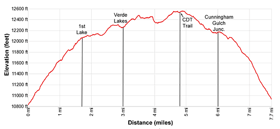
Elevation Profile
| Buy the BookThis opinionated guide includes all the hikes in the Ouray, Telluride, Silverton and Lake City sections of the website plus info on local services and nearby attractions. |
Driving Directions
From Silverton: Drive northeast through Silverton on Greene Street, the town’s main street, pass the courthouse (on the left) and bear right on County Road 2 toward Howardsville. The road is paved for the first 2.0-miles and then turns to a good gravel surface. Just before reaching Howardsville, turn right on County Road 4 (marked with a sign for the Old One Hundred Mine Tour). Follow CR 4, a good dirt road, for 3.7 miles up Cunningham Gulch to the ruins of a mine.
Note: County Road 4 splits part-way up Cunningham Gulch. Either road will get you to the trailhead. The road to the right (lower road) is easier.
Hikers in low clearance vehicles should park off the road near the mine and walk up the road about 0.8 miles, gaining about 380-ft., to the trailhead. If walking the road, add 1.6 miles to the round-trip to the trail distance.
The road crosses a bridge and then starts climbing up the right (west) side of the creek with the aid a long switchback. (The road gets rougher and steeper as it climbs. Vehicles with AWD/4WD with good clearance are recommended.) Follow the road for a little over 0.8 miles to an intersection with a road splitting off to the left. Those with good clearance and 4WD can turn left, following the road downhill and across the creek. The trailhead parking lot is just beyond the crossing. Use care during periods of high water.
If you are concerned about the creek crossing or clearance, continue past this intersection to an obvious parking area on your left. It is always best to check on current road conditions at the Silverton Visitor Center before setting out.
From Ouray: Follow U.S. Highway 550 South from Ouray for 29 miles to the turnoff to Silverton and then follow the Silverton directions to the trailhead.
Trail Resources
Trail Intro / Trail Photo Gallery / Trail Map
Basecamp(s) Information:
Silverton
Region Information:
Southwest Colorado
Other Hiking Regions in:
Colorado