Details: Ice Lake 
Distance: 7.8 - 8.2 miles (round trip)
San Juan National Forest, near Silverton in Southwest Colorado
By: Diane Greer
Hike Facts
- Distance: 7.8 - 8.2 miles (round trip)
- Elevation: 9,840-ft. - 12,392-ft.
- Elevation Gain: 2,552-ft.
- Difficulty: strenuous
- Trail Highlights: See Trail Intro
- Basecamp(s): Silverton / Ouray
- Region: Southwest Colorado
This wonderful hike visits two gorgeous lake basins, traverses wildflower-filled meadows and passes numerous waterfalls. Dramatic peaks punctuate the ridge forming the backdrop for upper Ice Lake, nestled in an alpine wonderland that invites exploration.
Trailhead to Lower Ice Lake
Distance from Trailhead: 4.5 miles (round trip)
Ending/Highest Elevation: 11,510-ft.
Elevation Gain: 1,670-ft.
The head of the South Mineral Valley is the starting point for Ice Lake, one of the premier hikes in the San Juan Mountains. The signed trail departs from the west end of the trailhead parking lot, located across from the South Mineral Campground (see driving directions below).
The trail crosses a meadow and starts climbing through a burn area on moderately steep switchbacks. At 0.4 miles the path crosses Clear Creek and ascends the slope to the west of the creek on well graded switchbacks with intermittent views of Twin Sisters rising across the valley to the south.
After 30 minutes a detour to the right (east) leads to a scenic waterfall tumbling down the rocky hillside scarred by avalanche activity. Beyond the waterfall the trail heads west, climbing steeply up a grassy slope filled with wildflowers. Keep a lookout for the ruins of an abandoned mining building and equipment on your left. The grade abates as the trail crosses a meadow and then enters the trees. The trail now climbs steep switchbacks up a headwall to Lower Ice Lake basin.
After gaining 1,600-ft. in 2 miles the trail crests the ridge into the beautiful Lower Ice Lake basin. Rock outcroppings provide a nice place to rest and enjoy the view of Fuller (13,761-ft.), Vermillion Peak (13,894-ft.), Golden Horn (13,780-ft.) and Pilot Knob (13,738-ft.) rising above the ridge at the head of the lower basin.
Lower Basin to Upper Ice Lake
Distance from Trailhead: 7.0 miles (round trip)
Ending/Highest Elevation: 12,270-ft.
Elevation Gain: 2,430-ft.
The trail now traverses lovely meadows on gentle grades, passing Lower Ice Lake nestled in trees to the left (south). Waterfalls, emanating from unseen alpine lakes and snowfields tumble down clefts in the rocky hillside to the north of the trail. During late July to early August the well-watered meadows around the falls host spectacular wildflower displays. Masses of columbines, larkspur, aspen daisies, chiming bells and cow parsnips blanket both sides of the trail.
At the head of the lower basin the trail curves left (south) and starts a steep ascent up the basin’s headwall. Ahead you will see a waterfall on the outlet stream for Fuller Lake cascading down a rocky crevasse. Just before reaching the waterfall the trail swings to the right (west), climbs a few steep switchbacks and then swings right (north) for the final stiff climb to the upper basin. Reach the top of the headwall in 0.6 miles after gaining 700-ft. in elevation.
The grade now abates as the trail traverse alpine tundra for the final quarter mile to Ice Lake (12,270-ft.). As you walk toward the lake note the faint trail climbing the grassy slope on your right (north). This trail leads to Island Lake.
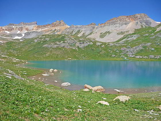
Turquoise blue Ice Lake sits in a magnificent cirque amid subalpine tundra dotted with wildflowers. U.S. Grant Peak (13,767-ft.) rises to the north. In a clockwise direction the sculpted peaks and ridges of Fuller Peak (13,761-ft.), Vermillion Peak (13,894-ft.), Golden Horn (13,780-ft.) and Pilot Knob (13,738-ft.) form the southwestern wall of the upper lake basin.
Return to the trailhead by reversing your route or, if you have time, take a side trip to Island or Fuller Lakes. (See descriptions below.)
Ice Lake to Island Lake
Distance from Trailhead: 8.4 miles (round trip)
Ending/Highest Elevation: 12,392-ft.
Elevation Gain: 2,552-ft.
A side trip to Island Lake (12,392-ft.) is well worth the effort. To reach the lake cross Ice Lake's outlet stream (to find the best place to cross wander downstream a bit) and then follow the faint trail climbing the grassy slope to the northeast. The trail is initially hard to see but becomes better defined further up the slope. As you climb, enjoy stunning views of the upper and lower Ice Lake basins.
The trail crosses the base of a tailings pile and then ascends above a rock outcropping before swinging left (north). The grade now abates as the trail traverses a hillside above the lake. The aquamarine lake is nestled in an intimate cirque at the base of U.S. Grant Peak. If you look carefully, you will see a faint trail climbing the talus ridge to the north of the lake. This route leads to the Ophir Valley. Total distance to Island Lake from Ice Lake is just over 0.7 miles with a 130-ft elevation gain.
Island Lake to Fuller Lake
Distance from Trailhead: 8.8 miles (round trip)
Ending/Highest Elevation: 12,605-ft.
Elevation Gain: 335-ft.
The gentle rolling hillsides beyond Ice Lake invite exploration. One popular side trip is the short hike to Fuller Lake. To reach Fuller Lake (12,605-ft.) head up the hill to the south/southwest of Ice Lake to a pond. (There is now a use trail, which fades in places, to help keep you on track.) Go around the left (east) side of the pond and then climb up the open hillside to the south/southwest of the pond. At the top of the hill is a broad shelf. The way to Fuller Lake should now be obvious. Cross a small creek and then travel along the west side of the creek to Fuller Lake. The lake is 0.9 miles from Ice Lake with a 335-ft. elevation gain.
From the lake enjoy fine views of Fuller Peak, Vermillion Peak and Golden Horn. An old metal-sided mining cabin still stands beside the lake.
Please Act Responsibly When Visiting Ice Lake
Ice Lakes is one of the most popular and heavily used trails in southwestern Colorado. Social media postings in the past few years have resulted in an explosion of visitors to the area. Meanwhile recent avalanches have scarred the Clear Creek drainage and a fire in October 2020 burned the lower section of the trail.
Read and follow Leave No Trace principles while hiking and camping in Ice Lakes and other public lands. It is imperative that we all act responsibly to protect and preserve this beautiful area.
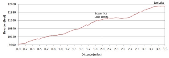
Elevation Profile
| Buy the BookThis opinionated guide includes all the hikes in the Ouray, Telluride, Silverton and Lake City sections of the website plus info on local services and nearby attractions. |
Driving Directions
From Ouray: Follow Highway 550 south from Ouray for 19.6 miles to CR 7. (The distance from Ouray is measured from the bottom of the switchback exiting the south end of town.) Make a sharp right onto County Road 7 (signed for the South Mineral Campground) and follow this good gravel road for 4.4 miles to the trailhead parking area on the north (right) side of the road across from the South Mineral Campground.
From Silverton: From the intersection of Highway 550 and the turnoff to Silverton (110), drive 1.9 miles north on Highway 550 to County Road 7. Turn left on County Road 7 (signed for the South Mineral Campground) and follow this good gravel road for 4.4 miles to the trailhead parking area on the north (right) side of the road across from the South Mineral Campground. If you reach Silverton you missed the turn.
Trail Resources
Trail Intro / Trail Photo Gallery / Trail Map
Basecamp(s) Information:
Silverton / Ouray
Region Information:
Southwest Colorado
Other Hiking Regions in:
Colorado