Details: Swiftcurrent Pass 
Distance: 8.0 - 13.6 miles (round trip)
Glacier National Park, near Many Glacier in Glacier Natl Park, MT
Hike Facts
- Distance: 8.0 - 13.6 miles (round trip)
- Elevation: 4,940-ft. - 7,185-ft.
- Elevation Gain: 335-ft. - 2,245-ft.
- Difficulty: strenuous
- Trail Highlights: See Trail Intro
- Basecamp(s): Many Glacier / St Mary
- Region: Glacier Natl Park, MT
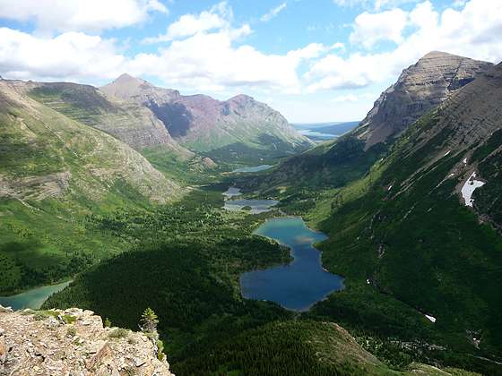
This beautiful hike up the Swiftcurrent Valley passes a chain of lovely lakes with terrific views of the surrounding peaks and then climbs a steep trail up to a pass on the Continental Divide. The trail to the divide features panoramic views of Swiftcurrent Glacier and the valley
To the Amphitheater

Distance from Trailhead: 8.0 miles (round trip)
Ending/Highest Elevation: 5,275-ft.
Elevation Gain: 335-ft.
The trailhead for Swiftcurrent Pass is located at the west end of the large parking area, past the Swiftcurrent Motor Inn. (See driving directions below for more information.) Follow the trail as it heads northwest up the Swiftcurrent Valley on easy grades, passing through mix forest. In a short distance cross Wilbur Creek on a wooden bridge. Openings in the forest around the creek crossing offer views of Wilbur Mountain (9,321-ft.) towering above the north side of the valley and the rugged cliffs of Grinnell Point to the south.
Pass the junction with the spur trail to Fishercap Lake (4,944-ft.) at 0.25 miles. The pleasant lake, reached by the short spur trail, offers nice views of the surrounding peaks and is a great place to spot Moose early in the morning.
A half mile from the trailhead the path traverses a small meadow offering your first views of Swiftcurrent Mountain (8,436-ft.) rising above the head of the valley. Soon the trail curves to the northwest as it continues traveling through forest. After walking a little over a mile the trees thin and intermittent open to Mt. Grinnell (8,851-ft.) rising above the south side of the valley.
Cross a wood bridge spanning a creek at 1.4 miles and reach the northern shore of Redrock Lake (5,082-ft.) at 1.6 miles. Wonderful views across Redrock Lake encompass Mt. Grinnell, Swiftcurrent Mountain and the headwall at the end of the valley. A pretty waterfall cascades down rocky slopes near the southwestern end of the lake.
The trail travels along the lake’s northern shore and then curves to the southwest around the head of the lake. Altyn Peak (7,947-ft.) and Mt. Henkel (8,770-ft.) fill the skyline to the east.
At 1.8 miles a spur trail to Redrock Falls branches to the left (south). The falls, actually a series of cascades on Swiftcurrent Creek dropping down rocky slopes and ledges into Redrock Lake, are a favorite destination for families and groups looking for an easy day.
Beyond the falls the trail continues ascending the valley on easy grade, passing through stands of trees and pretty meadows with fine views of Mt. Wilbur to the north, Mt. Grinnell to the south and Swiftcurrent Glacier, cradled atop a ledge near the top of the valley’s headwall. Waterfalls emanating from the glacier tumble down crevasses in the sheer headwall.
Cross a bridge over a creeks flowing down the south face of Mt. Wilbur at 2.25 miles. A forested section of the trail, starting at 2.6 miles, obscures views of the two lakes to the south of the trail.
Soon the trees give way to a large meadow with great views of Swiftcurrent Mountain and the waterfalls cascading down the sheer headwall at the end of the valley. To the south, massive Mt. Grinnell fills the skyline.
A swing bridge crosses the outlet stream for Windmaker Lake at 3.25 miles. The unseen lake is tucked in a small valley to the north of the trail.
At 3.4 miles Bullhead Lake springs into view. Stunning views extend across the lovely lake to the Swiftcurrent Mountain and the headwall at the end of the valley. To the southwest, Mt. Grinnell and Pt. 7,957 tower above the valley.
Follow the trail as it travels along the lake’s north shore. At the head of the lake the trail makes a wide arc to the south toward the headwall, passing through pretty meadows studded with beargrass spires, small stands of stunted conifers and lush fields populated with willows.
Cross Swiftcurrent Creek at 3.9 miles. Over the next one-tenth of a mile the trail will cross the creek three more times. Boards spanning the final two crossing will keep your feet dry.
You are now in a small, dramatic amphitheater at the head of the valley. Multiple waterfalls tumble down the headwall’s sheer cliffs to the lush slopes below. This is a great place to take a break and enjoy the scene before starting the climb to the pass. This lovely spot is also a great destination for hikers looking for a shorter, less strenuous 8.0 mile hike.
To Swiftcurrent Pass and Overlook

Distance from Trailhead: 13.6 miles (round trip)
Ending/Highest Elevation: 7,185-ft.
Elevation Gain: 2,245-ft.
Beyond the last creek crossing the trail starts a stiff ascent up the headwall, switchbacking through lush meadows dotted with stunted conifers. As the trail climbs the pretty meadows give way to rocky slopes. At 5.2 miles the path passes a beautiful double waterfall and then climbs a steep, narrow switchback heading northwest.
Three-tenths of a mile beyond the falls the grade abates a bit as the trail curves around a sheer cliff known as the Devil’s Elbow and then travels generally north on moderately steep grades, crossing a creek that drains snowmelt from the area around Swiftcurrent Pass. This section of the trail enjoys fine views of the Swiftcurrent Valley, Bullhead Lake, Redrock Lake and, in the distance, Lake Sherbourne.
The trail curves to the west at 5.9 miles and soon re-crosses the creek. Watch for a use trail branching to the left at 6.5 miles. The spur heads southeast for a short distance to an overlook with great views of Swiftcurrent Glacier.
At 6.8 miles a large rock cairn along the south side of the trail marks Swiftcurrent Pass (7,185-ft.). Ironically views from the top of the board pass are limited. For great views of the area to the west of the pass continue down the west side of the pass for about 0.3 miles to overlook. From this vantage point views extend southwest to Heavens Peak (8,987-ft.) and Mount Vaught (8,850-ft.).
After taking in the views, retrace your steps to the trailhead.
Hikers with the time, energy may want to climb the fire lookout atop Swiftcurrent Mountain (8,426-ft.). The trail to the lookout is located a short distance to the west of the pass. The steep trails climbs 1.4 miles up the south face of the peak, gaining over 1,250-ft. Keep in mind that it is a 16.4 mile round-trip hike to the pass from Many Glaciers, gaining 3,486-ft. Not a hike for the faint of heart.
Backpackers with reservation for the Granite Park Chalet or the nearby Granite Park campground will want to continue down the west side of the pass for 0.6 miles to the junction with the Highline Trail. The Granite Park Chalet is just 0.2 miles beyond. The campground is further to the west.
This is a long hike. Make sure you get an early start and keep an eye on the weather. The switchbacks to the pass are exposed and windy.
Elevation Profile
Driving Directions
From St. Mary: Drive north on US 89 for 8.5 miles and turn left onto Route 3, signed for Many Glacier. The turn is just before the town of Babb, MT. Continue along Route 3 for 12.4 miles to the large parking area at the end of the road. The trailhead is located at the west end of the parking area.
From the Many Glacier Hotel Complex: Head west on Route 3 for 0.9 miles to the large parking area at the end of the road. The trailhead is located at the west end of the parking area.
Trail Resources
Trail Intro / Trail Photo Gallery / Trail Map
Basecamp(s) Information:
Many Glacier / St Mary
Region Information:
Glacier Natl Park, MT
Other Hiking Regions in:
Montana