Details: Gunsight Lake 
Distance: 12.2 miles (round trip)
Glacier National Park, near St Mary in Glacier Natl Park, MT
By: Diane Greer
Hike Facts
- Distance: 12.2 miles (round trip)
- Elevation: 5,310-ft. - 5,351-ft.
- Elevation Gain: 1,270-ft.
- Difficulty: moderate-strenuous
- Trail Highlights: See Trail Intro
- Basecamp(s): St Mary
- Region: Glacier Natl Park, MT
A hike through forest with limited views leads to stunning vistas of Mount Jackson Gunsight Mountain and Fusillade Mountain towers above gorgeous Gunsight Lake as well as views of Citadel Mountain, Mount Logan and the Blackfoot and Jackson Glaciers.
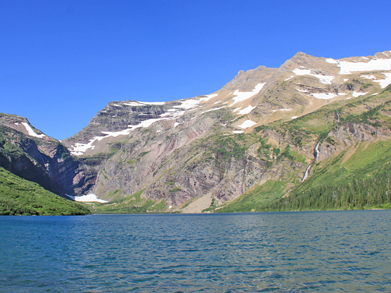
Gunsight Lake
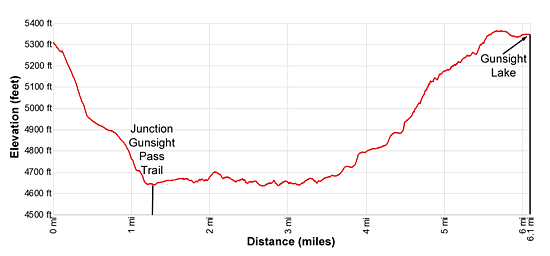
Elevation: 5,310-ft. at Trailhead at Jackson Glacier Overlook
4,645-ft. at Reynolds Creek Crossing
5,351-ft. at Gunsight LakePass
The hikes starts at the Jackson Glacier Overlook along the Going-to-the-Sun Road (see driving directions below). Before starting the hike take time at the overlook to view the Jackson Glacier clinging to Mount Jackson’s north face. The glacier is the 7th largest of the 25 remaining glaciers in the park.
From the overlook take the Piegan Pass (signed for the Gunsight Pass trail) toward the Gunsight Trail junction. The path descends southeast through a spruce-fir forest on moderate to moderately steep grades. At 1.1 miles views open to lovely Reynolds Creek to the right (west) of the trail.
At 1.2 miles take a short detour to the rock ledge above the creek to see Deadwood Falls. The falls tumbles down several levels of interested red mudstone formations. Pretty pools separate the drops.
Past the falls the trail turns left (east) and reaches the signed Gunsight Trail Junction at 1.25 miles. Straight ahead leads to Sun Point. We turn right (south) on the Gunsight Pass trail toward Gunsight Lake. The trail drops down and cross Reynolds Creek on a swing brings. On the far side of the bridge a spur trail leading to the Reynolds Campground.
Beyond the crossing the trail gradually swings to the right (southwest), traveling through forest on easy grades to the north of the St. Mary River. For most of the way the forest obscure the views, although occasional openings offer views of Dusty Star (8,064-ft.) and Citadel Mountain (9,030-ft.) rising to the south. The first good opening is reached at 1.8 miles as the trail briefly travels along the north shore of the St. Mary River.
At 2.7 miles the trail passes to the north of pretty little Mirror Pond set amid a lovely marshy meadow. Here terrific views open southwest to Mount Jackson, Fusillade Mountain (8,750-ft.), Gunsight Mountain (9,258-ft.) and Gunsight Pass.
Reach the junction with Florence Falls at 3.7 mile. Keep left to stay on the Gunsight Pass trail. The Florence Falls trail, branching right, leads to the base of a gorgeous falls that spills down a series of rock ledges. The round-trip detour to the falls is 1.4 miles.
Beyond the falls the trail ascends on easy to moderately-easy grades. At 4.3 miles the trail starts an ascending traverse along the lower slopes of Fusillade Mountain. A half mile beyond the forest gives way to meadows with scattered clusters of trees. To south enjoy great views of Citadel Mountain, Mount Logan (9,239-ft.), the Blackfoot Glacier, the Jackson Glacier and Mount Jackson (10,052-ft.).
The grade abates at 5.5 miles. Here views open to Gunsight Pass, the saddle on the ridge between Gunsight Mountain and Mount Jackson. As you proceed through meadows enjoy ever improving views of the high peaks towering above the head of the valley.
At 5.9 miles pass a trail branching left to a patrol cabin. We continue straight ahead to the foot of breathtaking Gunsight Lake (5,351-ft.) at 6.1 miles. Just before the foot of the lake a spur trail branches left, leading to the Gunsight Lake Campground. Beyond the campground a use trail travels through willows to the lakeshore.
Views extend the length of Gunsight Lake to the sheer headwall below Gunsight Pass. Mount Jackson soars above the south side of the lake while the Gunsight Mountain massif dominates the views to the west/southwest. Fusillade Mountain towers above the lake to the north. Glaciers and snowfields clinging to the high slopes of Gunsight Mountain feed a series of beautiful waterfalls tumbling down the peak’s rugged slopes and into the lake.
Retrace your steps to the trailhead when you are done enjoying the beautiful lake.
Elevation Profile
Driving Directions
From St. Mary, MT: From the intersection of Highway 89 and the Going-to-the-Sun Road, drive 12.6 miles west on the Going-to-the-Sun Road to the Jackson Glacier Overlook parking area on the south side of the road. Parking is limited. Unless you get an early start, consider taking the shuttle bus to avoid parking problems.
From West Glacier, MT: From the junction of US-2 and the Going-to-the-Sun Road, turn northwest on the Going-to-the-Sun Road and follow the road for 2.0 miles to a junction with the Apgar Visitor Center. Turn right to continue on the Going-to-the-Sun Road. Follow the road for 35.4 miles to the Jackson Glacier Overlook parking area on the south side of the road. Parking is limited. Unless you get an early start, consider taking the shuttle bus to avoid parking problems
Shuttle Bus
From St. Mary, MT: From the intersection of Highway 89 and the Going-to-the-Sun Road, drive 0.5 miles to the St. Mary Visitor Center and park. Take the Glacier Shuttle Bus, starting at the St. Mary Visitor center, to the Jackson Glacier Overlook stop. Shuttle buses run approximately every 15 minutes. Check at the Visitor Center for the most up-to-date information.
From West Glacier, MT: From the junction of US-2 and the Going-to-the-Sun Road, turn northwest on the Going-to-the-Sun Road and follow the road for 2.0 miles to a junction with the Apgar Visitor Center. Cross the intersection and park at the Visitor Center. Take the Shuttle Bus to Logan Pass and change to the East Side bus. On the east side get off at the Jackson Glacier Overlook stop, the second stop down from Logan Pass. Shuttle buses run approximately every 15 minutes. Check at the Visitor Center for the most up-to-date information.
Trail Resources
Trail Intro / Trail Photo Gallery / Trail Map
Basecamp(s) Information:
St Mary
Region Information:
Glacier Natl Park, MT
Other Hiking Regions in:
Montana