St Mary and Virginia Falls 
Distance: 3.2 - 3.8 miles
Glacier National Park, near St Mary in Glacier Natl Park, MT

St Mary Falls
If you like waterfalls you’ll love the hike to beautiful St. Mary and Virginia Falls. The short, popular hike features mountain views and an ascent up the lovely Virginia Creek Valley, passing multiple smaller cascades before reaching impressive Virginia Falls.
- Distance: 3.2 - 3.8 miles (RT)
- Elevation: 4,725-ft. at Trailhead
Maximum elevation - 4,835-ft. - Elevation Gain: 110-ft.
- Difficulty: moderate
- Basecamp: St Mary
- Region: Glacier Natl Park, MT
Trail Description - St Mary and Virginia Falls
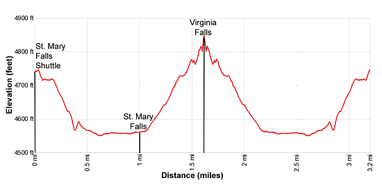
Elevation: Shuttle Bus Stop: 4,725-ft.
St. Mary River: 4,510-ft.
Virginia Falls: 4,825-ft.
Elevation Gain/Loss: 742-ft / -742-ft
This great little hike starts at the St. Mary Falls Shuttle Bus stop along the Going-to-the-Sun Road (see driving directions below). Add 0.3 miles to the distances in the description below if starting from the St. Mary Falls Parking area.
From the bus stop the trail heads southwest and soon starts descending on moderate grades through the area burnt by the 2015 Reynolds Creek Fire. As you descend enjoy views of Little Chief Mountain (9,541-ft.) and Almost-a-Dog Mountain (8,922-ft.) towering above the valley to the south. Dusty Star Mountain (8,064-ft.) rises to the southwest while Fusillade Mountain (8,750-ft.), Reynolds Mountain (9,125-ft.) and Heavy Running Mountain (8,016-ft.) dominate the view to the west.
At 0.3 miles reach a junction where our trail joins the St. Mary Falls trail descending from the St. Mary Falls parking area. A short distance beyond is a second junction with the Piegan Pass Trail. Bear left (southeast) to stay on the St. Mary Falls Trail toward St. Mary and Virginia Falls.
The trail now descends on easy grades to the north side of the St. Mary River at 0.6 miles. Here the trail turns right (west) and wanders through the trees north of the river to a bridge crossing the river below the St. Mary Falls at 0.8 miles.
Beautiful St. Mary Falls spills down three tiers into a large pool. Mist from the falls crashing over the rock envelops the bridge and the gorge, a cool respite on a hot summer day.
Beyond the bridge the trail briefly travels along the river before climbing over a low hill to an overlook above the west side of Virginia Creek at 1.0 mile. Here a waterfall spills down several levels of rock ledges. A spur trail leads to large rock ledge with an excellent view of the tallest drop. This is the perfect place to take a break or have a picnic lunch.
Beyond the falls the trail climbs up the west side of Virginia Creek on moderate grades, passing several pretty cascades along the way. At 1.5 miles reach a junction. The St. Mary Trail turns left (east) here. Stay right and arrive a stunning Virginia Falls, thundering over a rock ledge, at 1.6 miles. For additional views of the falls, head back to the junction and turn east. In a short distance you will cross a bridge with more great views of the falls.
When you are done enjoying the falls retrace your steps for a 3.2 mile round-trip hike (3.8 mile round trip hike if starting from the St Mary Falls parking area).
Elevation Profile
Driving Directions
Shuttle Bus Directions: From the intersection of Highway 89 and the Going-to-the-Sun Road, drive 0.5 miles to the St. Mary Visitor Center and park. Take the Glacier Shuttle Bus, starting at the St. Mary Visitor center to the St. Mary Falls stop. Shuttle buses run approximately every 15 minutes. Check at the Visitor Center for the most up-to-date information.
Driving Directions: From the intersection of Highway 89 and the Going-to-the-Sun Road in St. Mary, drive west on the Going-to-the-Sun Road for 11 miles and then turn left into the St. Mary Falls parking area. The parking area is very small and usually filled during the height of the summer. A better option is to take the shuttle bus.
Trail Resources
- Trail Photo Gallery
- Trail Maps
- Basecamp(s) Information: St Mary
- Region Information: Glacier Natl Park, MT
- Other Hiking Regions in: Montana