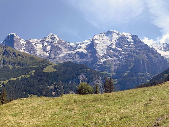
The Eiger, Monch and Jungfrau
This short, easy walk along a high bench on the west side of the Lauterbrunnen Valley features terrific views of the big three: the Eiger, Monch and the Jungfrau, along with the Abeni Flue, Mittaghorn and the Grosshorn. The walk is a good option on a day when the weather precludes hikes at higher elevations.
- Distance: 3.5 miles (One Way)
- Elevation: 4,935-ft. at Trailhead
Maximum elevation - 5,425-ft. - Elevation Gain: 490-ft.
- Difficulty: easy
- Basecamp: Lauterbrunnen
- Region: The Bernese Oberland
Trail Description - Grutschalp to Murren
The Grutschalp to Murren trail, a short, easy walk on a high bench along the west side of the Lauterbrunnen Valley, features terrific views of the big three: the Eiger, Monch and the Jungfrau, along with the Abeni Flue, Mittaghorn and the Grosshorn. The walk is perfect for families with young children or anyone looking for an easy stroll. The hike is also a good option on a day when the weather precludes hiking at higher elevations.
Grutschalp, located high above the Lauterbrunnen Valley, is a junction station on the Bergbahn Lauterbrunnen-Murren that links the cable car from Lauterbruunen with the rail line to Murren. In addition to the rail line two trails run between Grutschalp and Murren. This trail, the low route paralleling the rail line, follows a broad, easy path through forest and meadows. The Mountain View trail, a more demanding option, rewards the extra effort required to ascend high above the rail line with stunning views.
The day starts with a four-minute ride on the cable car between Lauterbrunnen and Grutschalp. The cable car station is located across the street from the northern end of the Lauterbrunnen Bahnhof (train station). (Only purchase a ticket for the cable car and not for the train that continues to Murren.)
After exiting the station at Grutschalp turn right and cross the train tracks. Continue straight ahead to a broad track. Turn left on the track and quickly reach a set of trail signs. Here signs point left (south) for both trails with Grutschalp to Murren trail, the low route, passing through Winteregg on its way to Murren (1h 15min). The Mountain View Trail (#351) travels through Bletschenalp (1h) and Almmendhubel (2hr 30 min) to Murren (3hr 10 min).
Follow the broad track as it heads south, traveling above the railroad track. In a short distance reach a junction. Here the Mountain View trail turns right (southwest) and starts climbing. Our trail toward Winteregg continues along the broad track, passing through a cluster of trees before emerging on pretty meadows.
Below the trail is the Lauterbrunnen Valley. A triad of massive peaks; the Jungfrau, Monch and Eiger, dominate the view to the southeast. Directly across the valley is Wengen set beneath the Mannlichen Ridge. As you continue along the trail enjoy splendid views of these peaks, along with the summits rimming the east wall of the Lauterbrunnen. Turn around occasionally for views that extend down the length of the valley to the Schynige Platte area.
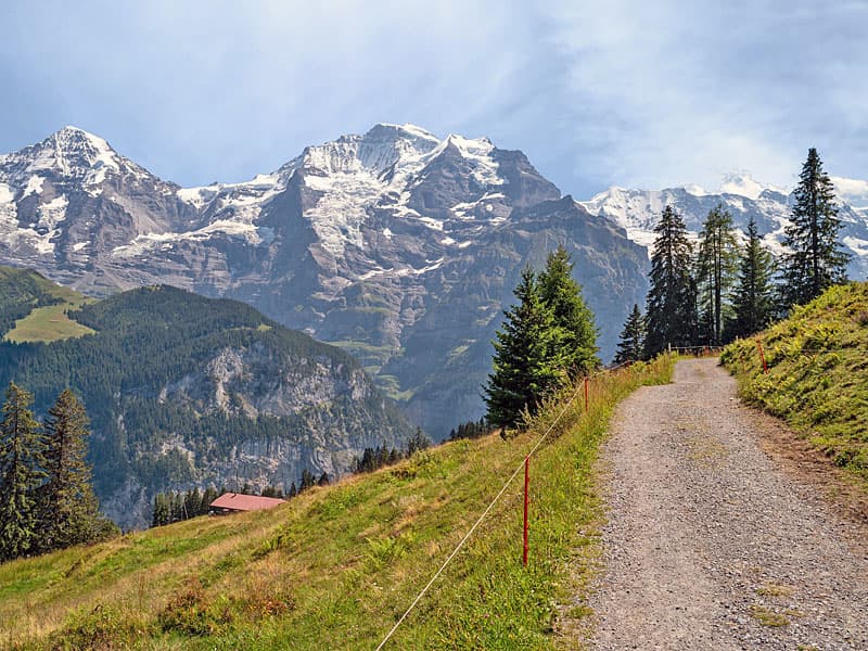
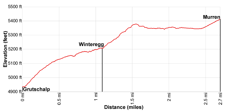
The well-maintained trail ascends on easy grades, traveling through meadows and clusters of trees. Reach Winteregg, with a restaurant and dairy, at 1.2 miles (1.9 km). Beyond Winteregg the path continues south, traveling through a forested area. As you near Murren enjoy ever improving views of the high peaks towering above the east side of the Lauterbrunnen Valley. Here the trail travels just above the railroad tracks.
Reach the Murren train station, located at the north end of the village, at 2.8 miles. Extend the hike by walking through Murren to Gimmelwald on a paved road with great views of the Jungfrau, Abeni Flue, Mittaghorn, Grosshorn and Breithorn rimming the east side and the head of the Lauterbrunnen Valley.
The track descends on moderate grades, losing 832-ft. (254-meters) over 1.7 miles (2.7 km) on its way to Gimmelwald. In Gimmelwald, take the cable car down to the Lauterbrunnen Valley and either ride the bus or walk back to Lauterbrunnen. The easy walk back to Lauterbrunnen adds about 3.0 miles (4.8 km) to the day. See the Lauterbrunnen to Stechelberg hike for more information.
Elevation Profile
Driving Directions
From Lauterbrunnen to Grutschalp: Across the street from the north end of the Lauterbrunnen Bahnhof (train station) find the Lauterbrunnen to Murren Bergbahn. Take the four-minute cable car ride to the top station at Grutschalp. (Only purchase a ticket for the cable car and not for the train that continues to Murren.) Check the SBB website and the SBB app for the current schedule.
From Murren to Lauterbrunnen: From the Murren train station at the north end of the village, take the train to the Murren Bergbahn, the cable car descending to Lauterbrunnen. The train ride takes 14 minutes and the cable car descending to Lauterbrunnen takes 4 mintues. The walk from the train to the cable car is short. You will not have any problems making the connection.
Alternatively, from the south end of Murren take the Schilthorn Cable Car (Schilthornbahn) to Stechelberg. You will need to change cars in Gimmelwald. At the bottom station for the Schilthornbahn catch the #141 bus bound for Lauterbrunnen. The ride to the Lauterbrunnen Bahnhof takes 14 minutes. There are many bus stops between the cable car station and the train station in Lauterbrunnen.
Check the SBB website and the SBB app for the current schedule and to the find the stop near your accommodation.
Trail Resources
- Trail Photo Gallery
- Trail Maps
- Basecamp(s) Information: Lauterbrunnen
- Region Information: The Bernese Oberland
- Other Hiking Regions in: Switzerland