Davos Panoramaweg - Gotschnagrat to Schatzalp 
Distance: 4.7 - 11.5 miles (one way)
near Davos in Eastern Switzerland
By: Diane Greer
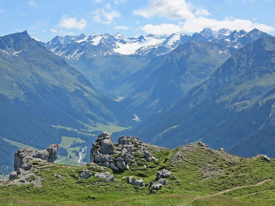
Silvrettahorn and the peaks to the east
The Davos Panoramaweg, a classic high traverse above the west side of the Davos Valley, features great views of the high peaks and glacier clad summits towering above the Davos, Klosters, Fluela, Dischma and Sertig valleys.
See Trail Detail/Full Description
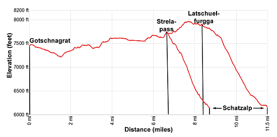
- Distance: 6.4 miles (one way) to Strela Pass
8.5 miles (one way) to Schatzalp
11.5 miles (one way) to Latschuelfurgga and Schatzalp - Elevation: 7,484-ft. at Trailhead
7,700-ft. at Strela Pass
6,106-ft. at Schatzalp
7,963-ft. at Latschuelfurgga and Schatzalp - Elevation Gain: 390-ft. to Strela Pass
-1,594-ft. to Schatzalp
-1,857-ft. to Latschuelfurgga and Schatzalp - Difficulty: moderate
- More Hikes in:
Davos / Eastern Switzerland
Why Hike Davos Panoramaweg - Gotschnagrat to Schatzalp
A cable car ride to Gotschnagrat leads to the start of the Davos Panoramaweg, a trail traversing high above the Davos Valley with amazing views of the surrounding peaks. Gotschnagrat, a stunning overlook above the confluence of the Davos and Prattigau valleys, serves up the first great views of the hike, stretching from Madrissa to the north to the glacier-clad Silvrettahorn massif to the east.
From the overlook the trail travels through meadows between 7,500-ft. and 7,600-ft. with unobstructed views of the summits rising above the Davos Valley and three long side valleys extending southeast. Various viewpoints and benches beckon hikers to stop and take in the scenery.
The traditional Panoramaweg trail visits Strela Pass before descending on moderately-steep grades to the funicular at Schatzalp. Alternatively, cut the trail short by descending to the middle station of the Weissfluhjoch funicular or extend the day by hiking to the wind swept Latschuelfurgga saddle before dropping down to Schatzalp.
The Panoramaweg passes through a few ski areas, which mar the otherwise lovely meadows along the trail. Try not to let these eyesores detract from this scenic trip filled with great views of the area's high peaks.
There are a lot of ups and downs along the trail but no real serious climbs. Only on the last trail segment to Schatzalp do we hit some moderately-steep descents. Note: The elevation gains and losses listed on the hike only indicate the net gain or losses and not the total gain and loss.
The hike can be walked in either direction and is shared by bikes. I advise getting an early start. Typically there are not many bikes on the trail early in the morning.
Elevation Profile
| Support our Site |
Trail Resources
Trail Detail/Full Description / Trail Photo Gallery / Trail Map
Basecamp(s) Information:
Davos
Region Information:
Eastern Switzerland
Other Hiking Regions in:
Switzerland