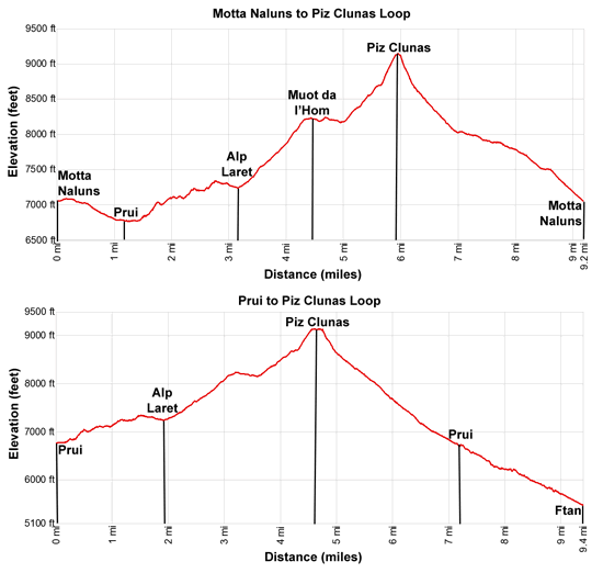
Hike Facts
- Distance: 7.3 - 9.2 miles (loop)
- Elevation: 7,008-ft. - 9,160-ft.
- Elevation Gain: 230-ft. - 2,152-ft.
- Difficulty: moderate-strenuous
- Trail Highlights: See Trail Intro
- Basecamp(s): Scuol
- Region: Eastern Switzerland
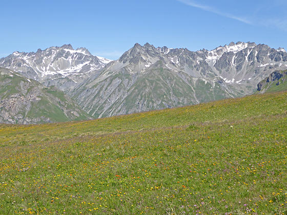
This loop hike ascends thorough lovely meadows to the overlook at Mout da l’Hom and then the summit of Piz Clunas with panoramic views of the high peaks towering above the Lower Engadine Valley and beyond.
Motta Naluns to Prui and Alp Laret

Distance from Trailhead: 3.1 miles (one way)
Ending/Highest Elevation: 7,238-ft.
Elevation Gain: 570-ft.
This description assumes you start the day by taking the cable car from Scuol to Motta Naluns. To shorten the hike, take a bus to Ftan and then ride the chairlift to Prui. If starting in Prui, subtract 1.2-miles from the trail mileage in this description. (See trailhead directions below.)
Outside the Motta Naluns lift station find the trail signpost and start walking west/southwest on a wide track toward Prui and Alp Laret. The trail initially travels on level grades and then descends on moderate to easy grades through wildflower-filled meadows and scattered trees to Prui at 1.2 miles.
Along the way enjoy great views to the south across the Lower Engadine Valley of Piz Lavetscha, Piz Pisoc and Piz Zuort rising above the Zuort Valley and Piz Plavna, Piz Plattas and Piz Nair towering above the west side of the Plavna Valley. The high peaks soaring above the Macun Lakes and Susch are seen in the distance to the southwest.
At Prui (aka Nateas/S-Chabaellera on the trail sign), bear right (northwest) on a two-track toward Alp Laret. The path travels through pretty meadows and then ascends steeply through a forest of larch and pine trees to a gravel road and trail junction at 1.7 miles. Turn left (west) on the road towards Alp Laret and Munt da l’Hom on the Via Engiadina trail. To the north views open to meadows, awash in wildflowers, and avalanche fencing high on the south facing slopes of Piz Clunas.
Walk a short distance on the road to an intersection and turn right (north) on a lesser used gravel road towards Alp Laret. Soon we bear right on a trail marked for the Via Engiadina that ascends a short distance uphill to another set of signs at 1.9 miles. Bear left toward Alp Laret. The trail to the right, signed for Piz Clunas, will be used on the return journey.
The undulating path climbs on easy to moderate grades through meadows sprinkled with wildflowers, offering great views of the peaks towering above the south side of the valley. Soon the trail crosses a creek on a wood bridge and then ascends through rocky meadows, cresting a ridge to a meadow clad bench at 2.7 miles.
Descend on easy grades across the bench toward Alp Laret. Soon views open west to Piz Cotschen rising above the Tasna Valley. Reach Alp Laret at 3.1 miles. The inn and restaurant, composed of three lovely old stone buildings, boasts superb views of high peaks of the Lower Engadine Valley.
Al Laret to Piz Clunas

Distance from Trailhead: 5.9 miles (one way)
Ending/Highest Elevation: 9,160-ft.
Elevation Gain: 1,922-ft.
Walk behind the Alp buildings to a junction where signs point left toward a path dropping down to Ftan and the continuation of the Via Engiadina up the Tasna Valley to Alp Valmala and Ardez. We turn right on the trail toward Piz Clunas (1-hr 45-min), Muot da l’Hom (1-hr) and Alp Clunas (1-hr 15-min).
The trail widens as it ascends the hill behind the Alp, passing an old water trough. Soon you will come to a steep track breaking off to the left. Either trail you are on (the main trail) or the one to the left works. The steeper path to the left has better views.
For this description we take the track to the left. As you proceed uphill the trail deteriorates, becoming eroded and braided as it ascends on moderately-steep to steep grades. The climb is accompanied by fine views of Piz Cotschen and the summits rising above the d'Urezzas and Urschai Valleys to the northwest.
Soon the trail heads for and then curves around the left side of a small knoll. This portion of the trail is poorly marked. Keep an eye out for red and white markers on rocks and stakes to keep on track.
Past the knoll our path reconnects with the main trail. The combined trail narrows as it climbs through open meadows. Views of the mountains rimming the Tasna, d'Urezzas and Urschai Valleys, to the west/northwest, along with the peaks rising above of the Lower Engadine Valley, to the south, continue to improve as you gain elevation.
At 3.7 miles the trail curves to the right (northeast), ascending steeply toward a saddle and Muot da l’Hom. Ahead views open to Minschun Pitschen and Piz la Greala to the north.
At 4.2 miles the trail crests a saddle and reaches a junction with a trail branching right to the Muot da l’Hom overlook. The path straight ahead leads to Piz Clunas and Alp Clunas. I recommend taking the 0.3 miles detour (round-trip) to the overlook for stunning, 360-degree views of the surrounding peaks before continuing to Piz Clunas. In addition to the peaks soaring above the the Lower Engadine Valley and rimming the Tasna, d'Urezzas and Urschai Valleys, the vantage point includes great views of Piz Minschun and Piz Clunas to the north/northeast.
Beyond the overlook the trail soon descends on easy grades to meet a gravel road. Follow the road to a sign pointing to the left toward Piz Clunas at 4.9 miles. There appears to be no trail at the marker. You can angle northwest across the meadows, cross a creek and soon meet the trail to Piz Clunas.
The easier option is to continue a short distance along the road and cross a stream. Past the stream, look left (north) for a narrow trail heading uphill. This is the trail to Piz Clunas. The trail become more distinct as it climbs steeply above the right (east) side of the stream and then curves to the right (northeast) through meadows. Soon we pass above Lac da Minschun, a small lake nestled in a bowl beneath the craggy slopes of Piz Minschun.
The path now climbs very steeply up the rocky hillside to the top of the ridge extending north from Piz Clunas. A stiff climb up the narrow ridge crest leads to the summit of Piz Clunas (9,160-ft.) at 5.9 miles. From the summit enjoy breathtaking, panoramic views. The mountains rimming the Tasna, d'Urezzas and Urschai Valleys dominate the view to west/northeast. The summits towering above the Lower Engadine Valley fill the skyline to the south. Vistas extend southeast to the peaks rising above the S-charl valley and southwest to the mountains soaring above Susch. The rugged summit of Piz Minschun rises above Piz Clunas to the north. Below the overlook distinctive Tarasp Castle is seen along the valley floor to the south of the River Inn.
Piz Clunas to Prui/Ftan or Motta Naluns/Scuol

Distance from Trailhead: 9.2 miles (loop)
Ending/Highest Elevation: 7,008-ft.
Elevation Gain: -2,152-ft.
When you are done taking in the views, follow the trail descending very steeply down the south facing slopes of Piz Clunas. Soon the path reaches switchbacks and the grade moderates a bit as it drops down to a gravel road and the Alp Clunas junction at 6.8 miles. Here hikers have a choice. Straight ahead a sign points across the road to a trail descending to Prui (50-min) and Ftan (1-hr 45-min). Alternative, turn left (east) and follow the road toward Chamanna Naluns (Naluns Hut/35-min) and Motta Naluns (1-hr 30-min).
To Prui and Ftan
To return to Prui and Ftan, cross the road and descend steeply through meadows with fine views to the south. A series of short switchbacks facilitate the descent. At 7.8 miles reach the junction we pass earlier in the day (at 1.7 miles). Now reverse the remainder of the walk to return to the chair lift at 8.5 miles (7.3 miles if starting at Prui).
Alternatively, you can walk all the way down to Ftan. To walk back to Ftan, at the junction at 6.8 miles, instead of turning left toward Prui turn right (west) and follow the signs back to Ftan at 10.6 miles (9.4 miles if starting the hike from Prui). The descent, losing over 1,500-ft., travels through meadows and forest with nice views of the high peaks to the south.
Whether you take the chairlift or walk down to Ftan, return to Scuol by bus. It is also possible to walk from Ftan to Scuol. The 2.6 mile walk loses 1,175-ft. on its way to Scuol.
To Motta Naluns
To return to Motta Naluns, turn left at the junction toward Chamanna Naluns (Naluns Hut) and Motta Naluns. Follow the road as it descends on easy grades to a junction at 7.1 miles. Here we bear left on a trail that crosses an old landslide and then descends through ski slopes to a junction below a man-made pond at 8.0 miles. This segment of the trail enjoys great views to the south. Along the way vistas open Piz Nair, Fuorcla Campatsch and Piz Campatsch to the north.
Turn left at the junction, following the trail signs back to Motta Naluns at 9.2 miles. At Motta Naluns ride the gondola down to Scuol.
Note: The trails along this hike, with the exception of the paths ascending and descending Piz Clunas, are open to mountain bikes. Typically there are few bikes on the trail. Much of this trail travels above the timberline and is not recommended during bad weather or if thunderstorms are threatening.
Elevation Profile
Driving Directions
From Scuol to Motta Naluns: From the Scuol Train Station walk northeast to the valley station for the gondola to Motta Naluns. The walk should take about 5 minutes. The ride to Motta Naluns takes about 12 minutes. See the Bergbahnen-Scuol Website for the gondola schedule. Depending on where you are staying in Scuol, you may wish to ride the bus to the train station. Consult the SBB Website/SBB app to find the bus stop nearest your accommodation. The train station is listed as Scuol-Tarasp on the SBB site.
Scuol to Ftan/Prui: From the Scuol Train Station, board the #921 but to Ftan and get off in the Cumun stop, located next to the Post Office in the center of town. From here, follow the signs to Ftan Fionas and the bottom station of the chairlift to Prui. The bus ride takes 11 minutes and the walk to the lift station takes about 10 minutes.
Consult the SBB Website/SBB app to find the bus stop nearest your accommodation. See the Bergbahnen-Scuol Website for the chairlift schedule. Note the lift shuts down for one hour at lunch time.
Trail Resources
Trail Intro / Trail Photo Gallery / Trail Map
Basecamp(s) Information:
Scuol
Region Information:
Eastern Switzerland
Other Hiking Regions in:
Switzerland