Details: Val Sesvenna and Fuorcla Sesvenna 
Distance: 8.6 - 10.2 miles (round trip)
near Scuol in Eastern Switzerland
Hike Facts
- Distance: 8.6 - 10.2 miles (round trip)
- Elevation: 5,930-ft. - 9,249-ft.
- Elevation Gain: 2,141-ft. - 3,319-ft.
- Difficulty: moderate-strenuous
- Trail Highlights: See Trail Intro
- Basecamp(s): Scuol
- Region: Eastern Switzerland
Ascend the Sesvenna Valley to a rocky, meadow-clad bowl accompanied by fine views of the peaks and summits rising to the west. Extend the hike with a very steep climb to Sesvenna Pass with stunning vistas of the rugged Sesvenna cirque and the summits towering above the S-charl Valley, the Swiss-Italian border and beyond.
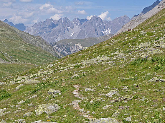
Trail up Val Sesvenna

Distance from Trailhead: 8.6 miles (round trip)
Ending/Highest Elevation: 8,071-ft.
Elevation Gain: 2,141-ft.
Take the bus from Scuol to S-charl. (See trailhead directions below.) From the S-charl bus stop follow the farm track heading northeast out of the main square up Val Sesvenna (Sesvenna Valley) toward Alp Sesvenna. A trail signpost at the bus stop in S-charl will help get you started.
The track ascends on gentle grades through pastures along the right (southeast) side of the Sesvenna stream (Aua Sesvenna). Soon the track enters the trees. As you ascend views open left (north) to interesting rock formation on the highly eroded slopes of Piz Madlain.
At 0.7 miles the track crosses the stream and the grade steepens. Ahead are views of Piz d'Immez and Piz Cristanas rimming the valley to the northeast while behind you vistas extend up the Val Tavru (Tavru Valley) to Piz Tavru.
At 1.1 miles the track crosses a tributary stream and then ascends through trees high above the Aua Sesvenna, crossing two more side streams at 1.3 miles. Beyond the crossings the trail, now a two-track, climbs on moderately-steep grades through meadows.
Reach Alp Sesvenna (6,886-ft.), sitting in large meadow-clad bowl at 1.6 miles. (This is a fine destination for parties looking for a shorter hike.) Here the road ends and the trail swings to the right (east) through open meadows to an intersection at 1.7 miles. Our trail continues straight ahead toward Fuorcla Sesvenna (2-hr 25-min). Ignore the route (blue trail sign), branching left (north/northeast), and ascending steeply up the Fora da l'Aua to Rims (3-hrs) and the Lischana Hut (4-hrs).
The path now traverses through meadows with fine views north to Piz Cotschen, Piz d'Immez and the Fora da l'Aua, a stream spill down the ridge between the two peaks, along with the summits towering above the Tavru Valley to the southwest. At 1.8 miles the path curves to the right (southeast), crosses a stream on logs and then traverses a scree covered slope before passing through a wood gate. Turn around here for great views of Piz Madlain.
Beyond the gate the trail ascends on moderate grades up the narrow valley, traveling through trees and intermittent meadows. At 2.4 miles the grade abates as the trees gives way to meadows scattered with shrubs.
At 2.7 miles the climb resumes on moderately-steep to steep grades up rocky meadows and scree covered slopes above the Aua Sesvenna. The stream, punctuated by small waterfalls, tumbles down the valley floor below the trail. As you climb turn around for superb views of Piz Minger, Piz Zuort and Piz Pisoc towering above the west side of the S-charl Valley.
At 3.0 miles the grade abates as the trail reaches a large open valley adorn with a spectacular display of wildflowers at the height of the summer. The unspoiled glen is nestled beneath the craggy, sculpted walls of Piz Cornet, Piz Cristanas and Piz Rims to the north. Piz Plazer and Piz Sesvenna tower above the valley to the south.
Near the head of the valley the trail curves to the left and ascends steeply along the north side of the valley. Soon views open to the summit of the Fernerspitz towering above the head of the valley. Turn around for more great views of Piz Minger, Piz Zuort and Piz Pisoc to the west/northwest.
At 4.2 miles the path curves to the right (southeast) as it crests a bench. Here the grade abates as the trail enters a small bowl. To the right (south) views open to a large moraine spilling down the slopes between Piz Plazer and Piz Sesvenna. Ahead the trail is seen climbing a very steep, rocky slope. The high peaks rising above the S-charl valley fill the skyline to the west.
Reach the foot of the rock wall at 4.3 miles. This is a good turnaround spot, especially if the trail to the pass is covered in snow/ice. Find a nice spot to sit and enjoy the gorgeous views to the west and the rugged peaks rimming the valley. When you are done taking in the views, retrace your steps to the trailhead for a 8.6 miles round-trip hike.
To Fuorcla Sesvenna

Distance from Trailhead: 10.2 miles (round trip)
Ending/Highest Elevation: 9,249-ft.
Elevation Gain: 3,319-ft.
Note: Continuing to the Sesvenna Pass changes the difficulty rating to very strenuous.
To continue to the Fuorcla Sesvenna (Sesvenna Pass), climb the very steep, rocky wall on a boot beaten track. There is a lot of loose rock, so take your time. Trekking poles are highly recommended, especially for the descent on the return leg of the hike.
Crest the top of the wall (8,694-ft.) at 4.5 miles. Here stunning views open Lai da Sesvenna (Lake Sesvenna) cradled in a rocky bowl beneath the cirque anchored by Piz Sesvenna, Piz Muntpitschen and the Fernerspitz. The Sesvenna Glacier clings to the slopes of the cirque. The path now swings to the left (east/northeast) and climbs steeply through rocky meadows and rock outcroppings to Fuorcla Sesvenna (9,249-ft.) at 5.1 miles.
The pass, a saddle on the ridge between the Schadler and Fernerspitz along the Swiss-Italian border, enjoys fine views of the distinctive Follakopf towering above the Lago Sesvenna to the east. A small tarn lies below the pass. The Rasassspitz and the Vernungkopf rise to the northeast. Behind you are panoramic views of the cirque anchored by Piz Sesvenna and its glacier while distant views stretch west to the Engadine peaks.
When you are done taking the views retrace your steps to S-charl for a 10.2 miles round-trip hike. Along the way enjoy the wildflower-filled meadows and great views of the summits rising above S-charl and the valleys to the west.
It is possible to continue down the east side of the pass to the Sesvenna Hut and then go over Schlinig Pass and down the Val d'Uina to Sur En in the Lower Engadine Valley. This 10-hour hike is best done as a multi-day hike by spending a night at the Sesvenna Hut, which offers meals and dormitory accommodations.
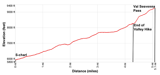
Elevation Profile
Driving Directions
From Scuol to S-charl: From the train station in Scuol, take the #913 bus headed toward S-charl and get off at the last stop in S-charl. The bus makes several stops in Scuol. Visit the SBB Website/SBB app to find the stop nearest your accommodations. The beautiful ride up the Val S-charl takes about 41 minutes.
If you are staying in another part of the valley, take the train or the postbus to Scuol and then catch the postbus to S-charl. Note: This is a very popular route. Get an early start and if possible purchase your tickets the night before the hike.
Trail Resources
Trail Intro / Trail Photo Gallery / Trail Map
Basecamp(s) Information:
Scuol
Region Information:
Eastern Switzerland
Other Hiking Regions in:
Switzerland